
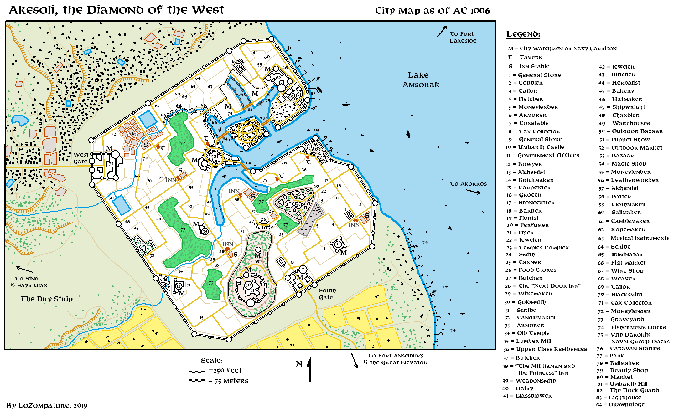
A city map of Akesoli
by LoZompatore.This is an attempt of mine to map the city of Akesoli according to the information provided in X10 module "Red Arrow Black Shield" and other official supplements. The idea is to add details useful for the "Escape from Akesoli" section of X10 and also to provide some background for other official and fan-made adventures in the area.
In my opinion it is possible to draw a map of the city by using the City Escape Flowchart (X10 page 5 with notes on page 3) as a reference.
Notice, in fact, that by placing all 25 locations from A to Z (the "O" letter is missing) in the circles starting from the top left hand corner you get a pretty rational city layout, as shown in figure below:
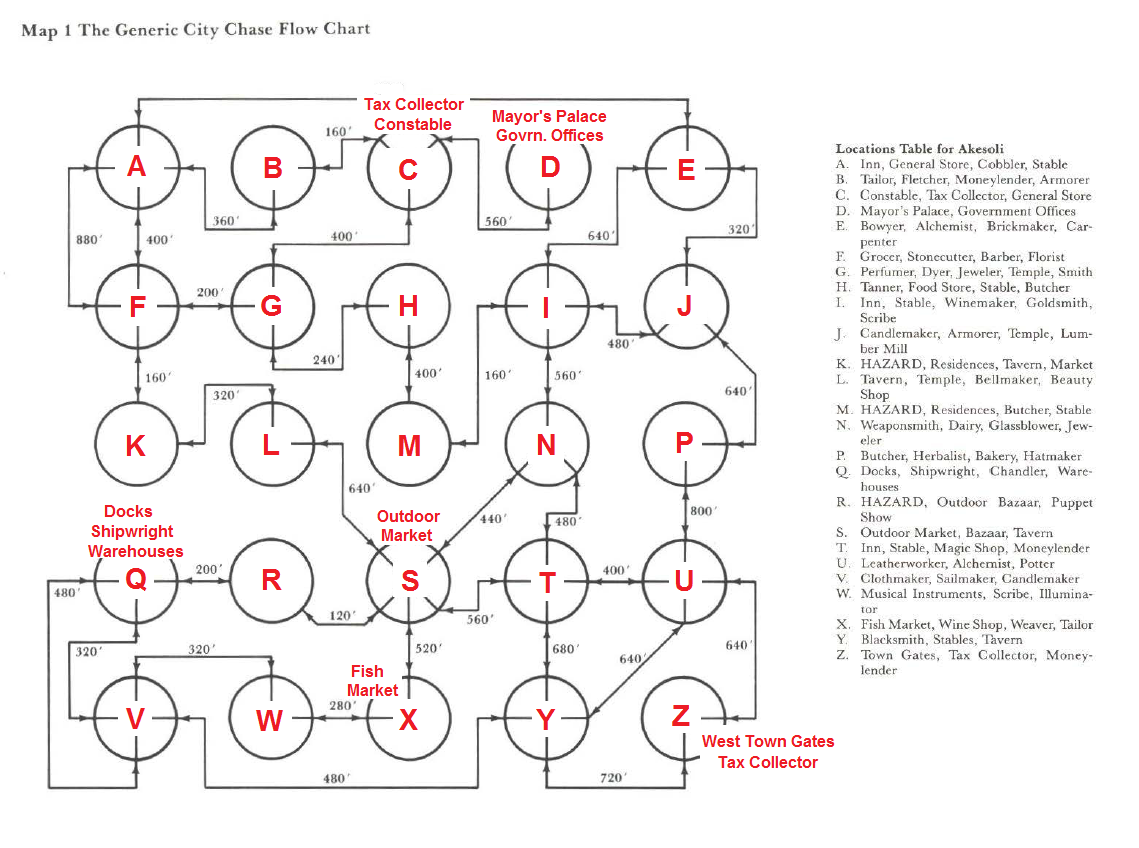
Notice in particular the following points:
- The city gate ends up in a corner of the flowchart;
- The large outdoor market is located in the middle of the flowchart and is surrounded by five roads;
- The docks and any other water-related facilty are located around a disconnected section of the flowchart, as if a large body of water was placed in the middle of these locations, preventing direct communication among them. This body of water is possibly the city internal harbor;
- The Mayor's Palace and the Government Offices end up in a dead end of the flowchart, as if they were located on a fortified location like a castle on a hill;
- A Tax Collector is located close to the city gate, while another one is placed close to the city walls.
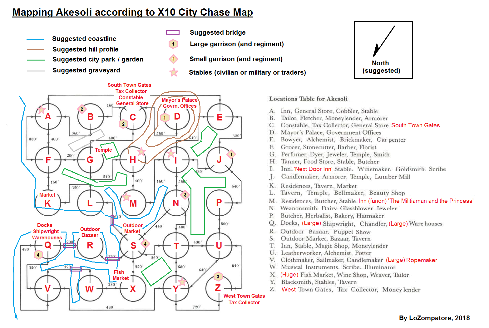
Notice also that many other city sections are disconnected from each other. In my opinion it is possible to assume that these disconnections are due to some public spaces laying in the area, such as canals, parks, gardens, a graveyard and so on. Canals should depart from the central harbor inferred above and disconnect the surrounding sections; actually, in order to explain some odd features of the City Escape Flowchart, it could be assumed that a few (draw)bridges cross the canals at suitable locations.
Parks and gardens should be quite widespread in the city as, according to GAZ11, Akesoli is the main base of operation for Umbarth Merchant House, which is mostly controlled by elves.
Further information may be added to this city map sketch from other official supplements, namely:
- From available regional maps (GAZ11, TM1, etc.) Akesoli should actually have two city gates, one located to the west (trading route with Sind) and another located to the south (trading route with the southern shore of Lake Amsorak and Akorros). In my opinion the second gate should be placed on section "C" on the map above, where the second tax collector and the constable are located. It could be inferred that this second gate is not shown in the City Escape Flowchart of X10 because this is where the main forces of the Master are attacking the city and so this is not a suitable escape route for the PCs.
- From GAZ11 Akesoli has a huge fish market (located in section "X" on map above), large shipwrights and warehouses (section "Q") and large ropemaker workshops (albeit not shown in X10 map, I believe a suitable location for them could be section "V").
- From GAZ11 (background of NPC Boris Staffleheim) Akesoli City Guard is divided among four Captains. For this reason I figured out four major garrisons, each commanded by a Captain. Obvious locations for these garrisions are the two city gates (sections "C" and "Z" of X10 map), the Mayor's residence and Government Offices (section "D") and the city docks (section "Q"). I also added four minor garrisons - each one under the control of one of the Captains - in other locations associated with the military, namely the two city armorers (section "B" and section "J"), the weaponsmith (section "N") and the outdoor market (section "S").
- From the map of Darokin City of GAZ11 it is possible to infer the general layout of city walls and local fortifications, as well as the average distance among towers and other details related to city defences.
- I incorporated the temples of sections "G" and "L" in a single temple complex as they are quite close to each other and given the large number of Immortals revered by the Darokinians. Most city temples would be located in this religious district; to give some variety I assumed that the temple in section "J" is an old complex where minor and half-forgotten Immortals are revered. A logical location for the ciy graveyard would be the area between the temple complex and the buildings of section "B". I also added a small hill surrounding the complex to provide further detail to the city layout.
Results are shown in the scheme below, which also highlights the location of city stables and of two inns (the "Next Door Inn" where the PCs are located in X10 and "The militiaman and the princess" a fan-created inn described here.
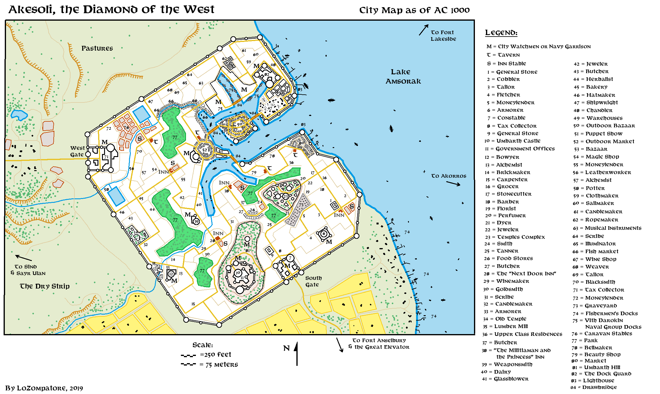
Now, in order to match the position of available landmarks (Amsorak lake to the east, a gate to the west and another gate to the south) I think the city map works best if it is tilted by some 135 degrees counterclokwise, as shown below. This would also give a diamond shape to the city perimeter, which I believe is in tune with the merchantile attitude of the city (the city could aptly be addressed as: "Akesoli, the Diamond of the West").
Main city streets are drawn according to the shape they have in the Generic Chase Flow Chart, slightly adapted for obstacles and city walls. For the sake of simplicity I did not considered travelling distances shown in the Flow Chart: I added minor roads which could account for any distance travelled by the PCs during their wandering while in the city.
According to distances shown in the Chase Map of X10 a suitable size for the city could be some 1500 yards x 1500 yards on the diamond's diagonals, for a total area of about 0.75 square miles. As Akesoli is inhabited by 17000 people (GAZ11) then its population density would be around 22300 people per square mile, which is about half of the average population density of a typical medieval town in the real world. This is consistent with the large number of unsettled spaces in the city due to parks, gardens and hillsides.
About areas outside the city walls I'd say that the shoreline of Lake Amsorak would be dotted with small docks and other facilities for the large fishing industry of the city. I figure most of the (insufficient) cultivated fields are located in the southern part of the map, close to the lake shoreline, while the western lands connecting to Sind would be mostly grasslands and badlands as, according to the introductory description in X10 modules, occasional sandstorms are reported in Akesoli.
The final map would appear as follows:
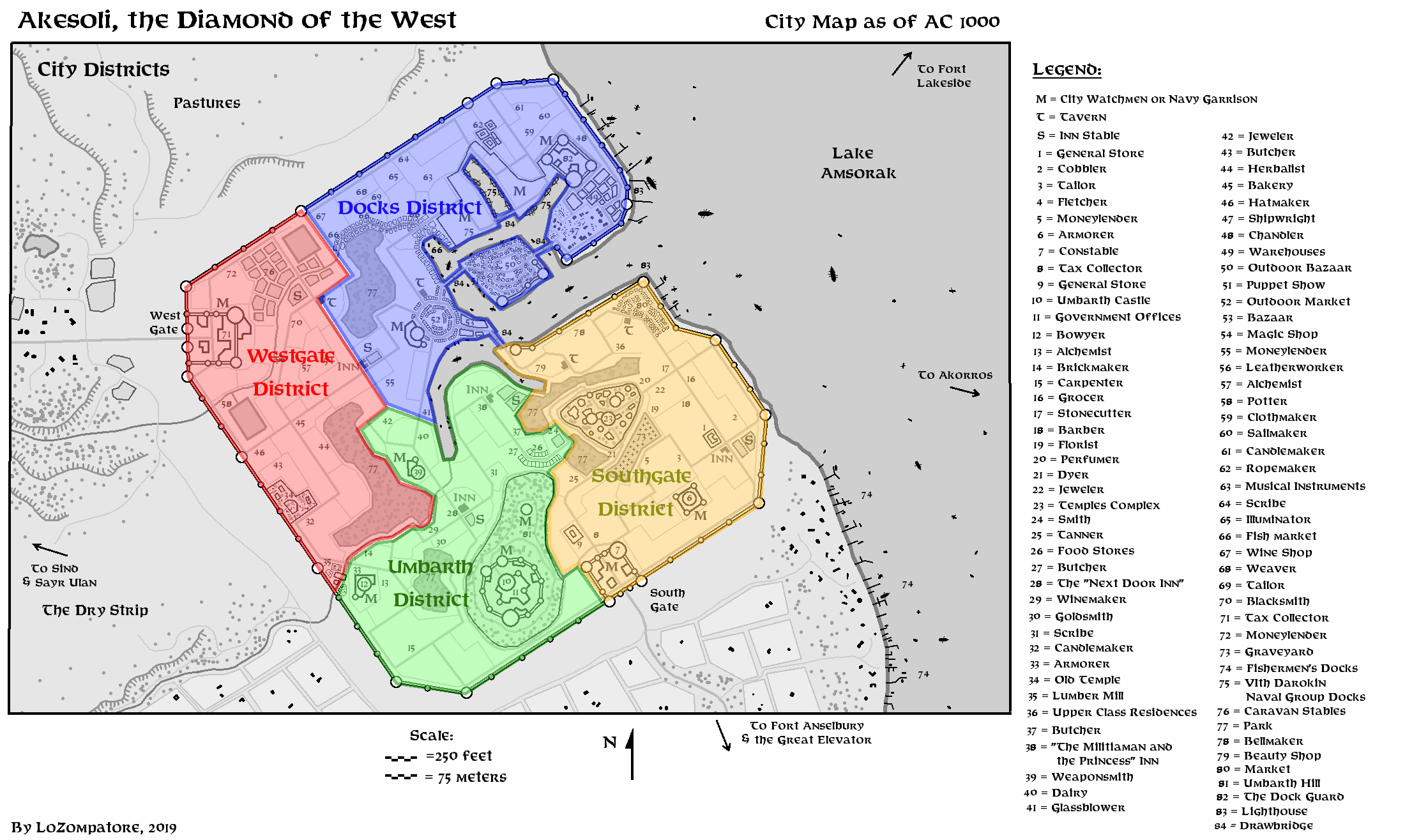
Division in City Districts:
City division in four districts could be as follows:
The city of Akesoli in AC 1006:
It is interesting to point out that the post-WotI population of Akesoli is 23000 people (AC 1010 - PWAI) with an increase from a GAZ-era (AC 1000) population of 17000.
In my opinion this is due to an influx of displaced people from Sind following the Hulean invasion of AC 1005 and, later, of Hulean and Sindhis refugees after the Master's defeat.
Most of the Sindhis would be hostile to the Master and at least some of them would act as an exiled opposition to the Hulean occupation of Sind.
Most of these extra people would likely be accomodated in poor suburbs outside the city walls but, given the dynamic government of the city, it is possible that, in the AC 1005-1006 timeframe, some parks and other public places will be demolished to make housing room for the wealthiest.
I guess the refugees - both rich and poor - could represent an interesting source of information for the PCs in the days preceding the Hulean attack.
A reference city map for AC 1006 at the moment of the Hulean invasion (estimated population of Akesoli around 20000) could be as follows:
Akesoli City Guards breakdown list:
On a final note, I provide some rationale on the size and strength of the city garrison in Akesoli by the time of the Master's invasion in AC 1006.
Notice that most of these forces will not be available due to the disruption caused by the surprise attack of the Huleans, nevertheless the PCs may be able to salvage some of these units if they manage to intervene during the early stages of the attack.
The size of the City Watchmen is unknown, albeit on X10 it is said that, if the PCs manage to rally the population, they will be joined by a group of 200 City Watchmen armed with swords. I believe that the overall composition of the City Watchmen should include also archers and cavalry (to mirror the average composition of a regular or reserve Darokinian Legion) so I guess the 200 swordsman are actually fighters who were not stationed on the city walls (i.e. no archers) and who did not manage to reach for their horses at the stables (i.e. they are acting as dismounted cavalry).
Peacetime military for Darokin is 2% of the total population while, during war time, it may reach the 15%. As Akesoli is a frontier town bordering a country which was conquered just the year before by the hostile forces of the Master I would say that the population of Akesoli has partially mobilized, with a military summing up to 8% of total population.
For a city of 17000 this equals to 1360 people (Sindhis refugees are not counted in the total population available for enlisting).
As city defence is shared among 4 Captains I guess it is safe to assume there are 4 units of City Watchmen in the city.
I would add a small garrison dedicated to Umbarth House safety and half of a Darokinian Naval Group to patrol Lake Amsorak waters (the other half of this group would be based in Akorros).
The overall breakdown would look like as listed below; most units would have a mixed human-elvish composition due to the influence of Umbarth House.
Notice that I intentionally placed more than 200 people under every single Captain of the City Watchmen, which is approx. two times the standard personnel a captain commands in the Darokinian Army. This is to reflect the disorganization and the inefficiency of the recent mobilization process of AC 1005-1006, as no skilled officer is still available to take charge of part of the troops. This fact is well-known by the Huleans and is fully exploited during the attack by swiftly isolating groups of soldiers from their far-away officers to more easily subdue them.
Rumors and complaining by soldiers and non-commissioned officers may filter to the PCs' ears a few days before the attack; if the PCs realize that the City Watchmen actually beg for competent commanders they could be more tempted to take charge when the situation turns for the worse.
City Watchmen Company (4 units; commands at Southern Gate, Western Gate, Dock Guard and Umbarth Castle)
Personnel: 214
Commander: Captain, F6, except for Boris Staffleheim, which is a F10
Deputy Commander: F5
Heroes: F4, C4
Regiments 1-2: each with 30 light infantry F1 armed with swords, 1 seargent F2
Regiment 3: 40 archers F1 with long bows, 1 seargent F2
Regiment 4: 40 archers E1 with long bows, 1 seargent E2
Regiment 5: 40 light cavalry F1 with short bows, 1 seargent F2 on war horses
Regiment 6: 30 light cavalry E1 with long bows, 1 seargent E2 on war horses
House Umbarth Home Guards (1 unit at Umbarth castle)
Personnel: 81
Commander: Captain E6
Heroes: E5, C5
Regiment 1: 30 archers E1 with long bows, 1 seargent E3
Regiment 2: 30 light infantry F1 , 1 seargent F3
Regiment 3: 15 light cavalry E2 , 1 seargent E4 on war horses
6th Darokin Naval Group (1/2 unit, the other half is stationed at Akorros)
Personnel: 423 + 80 nonfighting sailors
Commander: Captain, F5
Regiments 1-6: each with 53 marines on two small sailing ships (10 nonfighting sailors each)
Regiment 13: 104 marines on a large sailing ship converted to troop transport (20 nonfighting sailors)