
Mapping the Plateau with and without the original B3 module
by LoZompatore.Notice that the "new" B3 version lacks of the whole introduction, which describes the Adri Varma region and its towns. So I think that these missing information should be referred to the plateau, anyway. The only thing to be transferred should be the Castle of Argenta; even elves and dwarves clan of the plateau (that are connected with castle of Argenta story) should not be moved, because they could be easily substituted in the "new" B3 module by local elves an dwarves of Karameikos.
Last evening I did a little mapmaking with hexmapper and Paint. I prepared a map of the Adri Varma composing all the official maps without considering B3 module. Most of the region is covered by WotI and CoM, but you'll have some minor details (about roads) also in X11 and in Wendar map on PWAI.
(By the way: I prepared some extra hexes for the Hexmapper; if you like to have these symbols i put them here
Unzip the file and replace your "Hexes" folder in the Hexmapper with this one.)
Here is what we have:
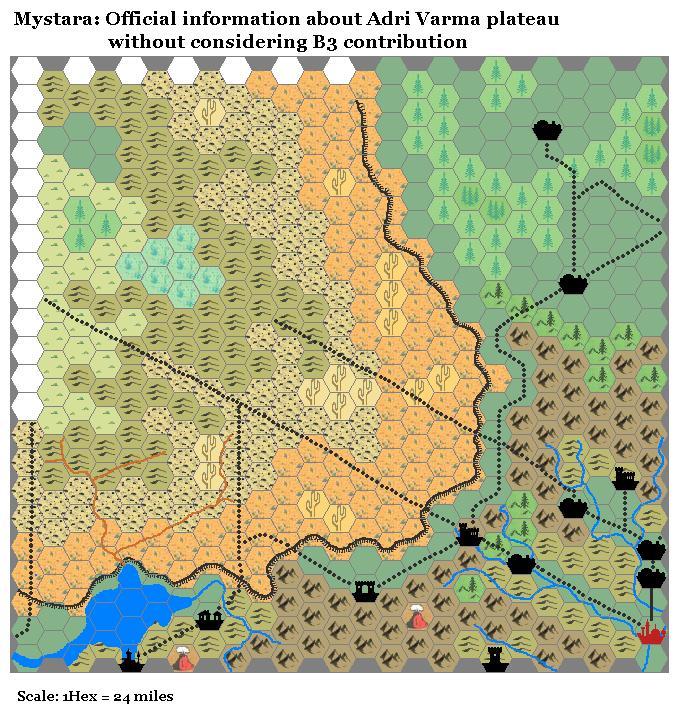
Let's call this map "The official Adri Varma", to distinguish it from B3 map.
Notice the possible intersection between the road going N from Sind, and the southeast road going NW.
Without modifying this map, I tried to add as much features as possible from B3 map. Here is what I got:
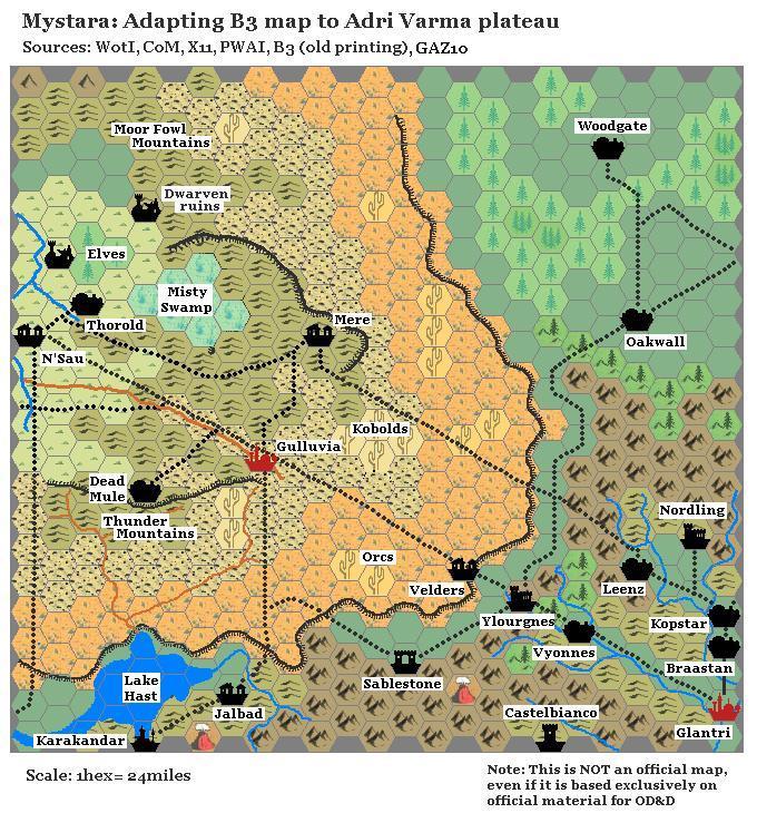
In detail:
- I considered B3 map as an old map showing this region in a period of wetter climate, before the E/SE area of the plateau became a desert. I also assumed that N direction in B3 map should be a little rotated counter wise, in order to better match the maps;
- I considered the swamp showed in the official Adri Varma as the western remnant of the Misty Swamp; I added all the other locations referring to this feature;
- I placed B3 cities and towns considering roads intersections and trade roads showed in the official Adri Varma map. So, for example, I put the village of Velders along the road going NW from Ylourgne, and Gulluvia at the intersection of the two major roads on the plateau;
- Mountains are transformed to hills. Most of them do not correspond to the old B3 map, but, with some assumptions (such has an hilly terrain where the eastern part of Misty Swamp once laid) it is possible to have at least a partial match; the region around B3 castle of Argenta does not match at all; I didn't care much about this, considering that this palace should be transported to Karameikos anyway;
- Forested areas are gone, substituted by desert/wastelands. There is only a small wood in the NW corner of the official Adri Varma, which I populated with the elves cited in B3 map.
- About dwarves: Your comments are true; these dwarves could be refugees from Glantri. Old B3 shows two dwarven colony; the first is in the Moor Fowl Mountains and now it is abandoned; the other should be located somewhere in the old Misty Swamp (in my map maybe it is in the hills east of the swamp remnants)
- I added orcs and kobolds lairs considering that - as from old B3 - the road between Gulluvia and Velders is sometimes raided by them. I put the lairs in cactus areas (where it should be easier to find water), with the kobolds nearer to the hills.
- I added the river showed in B3 map, considering its eastern branch as a seasonal river. I also added B3 road network superposing it to the official Adri Varma roads.