
Thoughts about Bellissarian maps
by LoZompatore.Some thoughts about Bellissarian cartography.
NOTE ABOUT MAPS: It is possible that the website in which I put my maps exceeds its data transfer capabilities, thus not showing the maps in this thread. You can try again later, otherwise you can download here the zipped version of all the maps (total: 1.6Mb):
The official maps of Bellissaria (DotE, PWAI, PWAIII, WotI) show the island in a very large scale (72 miles/Hex, with the exception of WotI's map which shows about 1/3 of the island in a 48 miles/Hex scale)
I made a conversion in a 24 miles/Hex in a very simple way, basically by superposing a suitably-scaled hexed grid on the 72-48 miles/hex maps, and then filling the smaller hexes depending on the terrain type on the larger scale maps. The new maps show very large stretches of identical, uniform terrains (especially plains and hills) that I "spiced" up a little by adding every bit of information about Bellissaria I was able to find in DotE and PWAs manuals.
The resulting full map of Bellissaria is this:
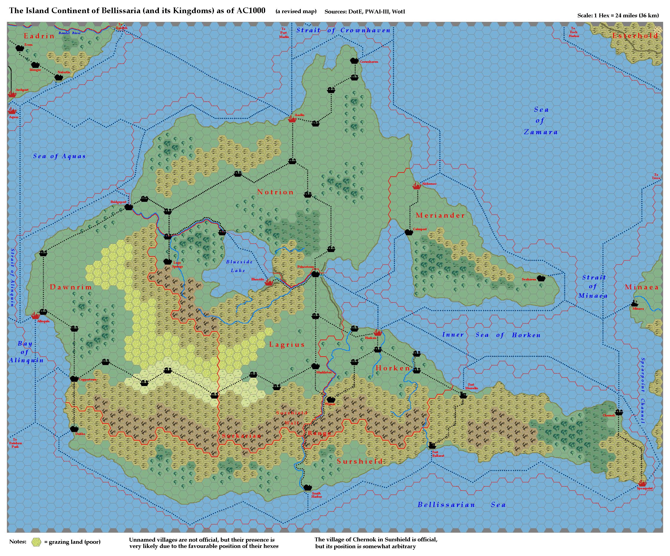
The main modifications to the "standard" map of Bellissaria are essentially these ones:
1) I added a new terrain tile: the "poor grazing land" of GAZ12 (Ethengar) with which I filled most of the plains in the central region of the island. This is because the DotE set says that "Central Bellissaria, which is not well-watered, is pretty arid, but doesn't quite constitute desert
it's just scrub country. The rest of the island is well-irrigated."
2) I added some villages in the most logical places (I did not give names to them). "Logical" places include the intersection of two major roads, and most places where a road makes a turn without any apparent reason. In the latter case I supposed that the road proceeds straight until it reaches a village, and then it departs from the village toward another direction.
In the following you will find separate maps for each kingdom (in alphabetical order) and a brief summary of the modifications I added. I tried to stay as much canonical as possible.
KINGDOM OF DAWNRIM:
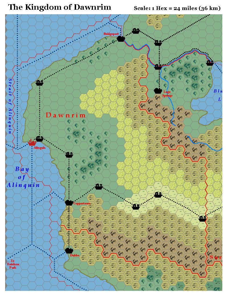
Modifications:
I turned vast stretches of plains into poor grazing lands, to take in account for PWAI info about (not very lucky) sheep and goat farming activities. In particular, I converted the plains just north of the (canonical) steppes, in order to explain why the road connecting Dawnrim and Lagrius was built on the steppes instead of the plains (if the plains are mostly arid, the steppes become a preferential choice for road and village-building).
KINGDOM OF HORKEN:
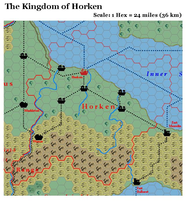
Modifications:
This kingdom is crossed by a large network of roads, so it has a large number of villages.
I added a couple more villages at the mouths of the rivers E and W of the capital, due to the fact that PWAI says that there are many deep water harbour and naval wharfs along the coast.
The same PWAI says that the plains of Horken are a mix of grasslands and woods, so I added some sparse hexes of forest along the rivers. Their number is quite small and it doesn't modify the hex terrain type in the larger scale (72 miles/hex) maps.
I added a road leading south from Wymar to South Harbour in the kingdom of Surshield. The road seems logical, due to the fact that Horken is a trading kingdom (PWAI) and that the Surkarian Range between the two cities is particularly narrow.
KINGDOM OF LAGRIUS:
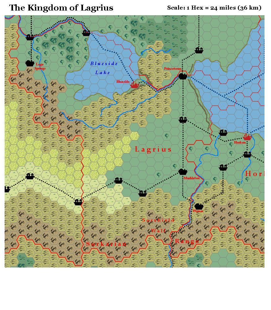
Modifications:
I changed some plains with the poor grazing lands, connecting them to the same terrain hexes of Dawnrim (see), basically for the same reason I explained in Dawnrim entry (the road that cross the steppes instead of the plains).
PWAIII says that Lagrius doesn't have a true access from the sea. So I supposed that the coastline is very steep, preventing the building of seaport and major harbours. I added an escarpment also on the hills just east of the capital city. That's because PWAI says that Blueside city is protected by the lake on one side, and by a steep range of hills on the other side.
The river between Blueside and Princetown has maybe dug his way through the higher land, carving a canyon or a deep valley along its route.
I added a village at the end of the trade route that crosses the lake starting from Blueside city.
KINGDOM OF MERIANDER:
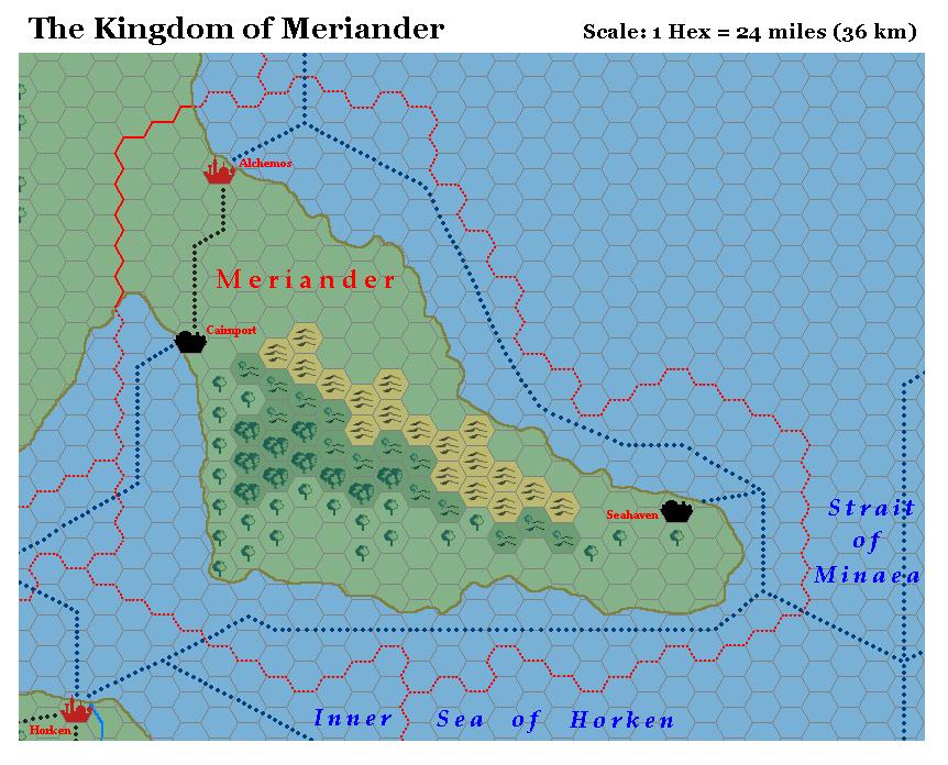
Modifications:
In the official maps this kingdom has absolutely no roads. I added a road between Alchemos and Cairnport because its really too useful to be ignored. It allows trade between the two cities avoiding to sail around the whole Meriander peninsula.
I did not add any other road, supposing that the ruling class of wizards (Alchemos has a famous magical university) likes the kingdom to be mostly wilderness.
I added some forest hexes and I changed to forested hills some hills in the south, according to PWAI info about wide forests in the south..
KINGDOM OF NOTRION:
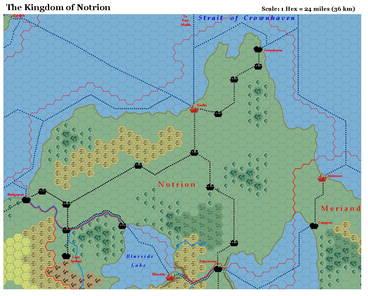
Modifications:
I added some villages along the three roads departing from Aaslin. As a result, the NE and the south regions of the kingdoms appear to be quite civilised. The presence of some villages and other settlements in the NE part of the kingdom is also stated in PWAI.
We may imagine that the regions far from the roads are mostly wilderness, in order to justify the very small population of this huge kingdom. The situation may be similar to that of an Alphatian "far west" with "colonists" mostly settled along the major penetration routes in a wild area.
Notice that the two nearest Alphatian kingdoms (Eadrin and Randel) are not particularly overpopulated, nor they are interested in strong emigration policies (Eadrin is a relatively poor kingdom which suffers the competition of nearby Arogansa, while Randel is a militaristic kingdom).
KINGDOM OF SURSHIELD:
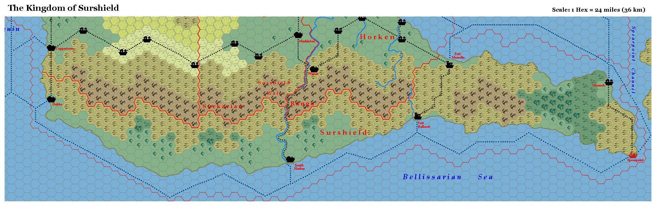
Modifications:
I added the road from South Harbour to Wymar in the kingdom of Horken (see). Notice that Surshield does not seem to have major roads in the E-W directions (distances are enormous, and the terrain is not very suitable for road building). The South Harbour-Wymar road is almost necessary, otherwise a merchant should have to sail around the long Spearpoint peninsula just to trade with the nearby kingdom of Horken.
I added the official village of Chernok (PWAIII), even if its position is not explicitly known. We just know from PWAIII that the village is relatively near to Spearpoint, and it is ransacked by Minaean pirates in AC1012. I placed Chernok along the Spearpoint Channel coastline, near the intersection of two major sea trade routes.
I changed some hills with wooded hills in the southern coast of Surshield, considering that precipitations along the southern coastline should be more abundant than the northern side of the Surkarian Range.
About the mountains: notice that the DotE calls "Surkarian Range" the long mountain chain between Spearpoint and Dubbo, while the PWAs maps call the same region with the name "The Surshield Wall". Instead of dropping one of these two names, I preferred to maintain the term "Surkarian Range" for the whole chain and to consider the term "Surshield Wall" as referred to a part of the range (possibly the highest or the steepest part of the Surkarian Range).