
Barimoor Research
by Robin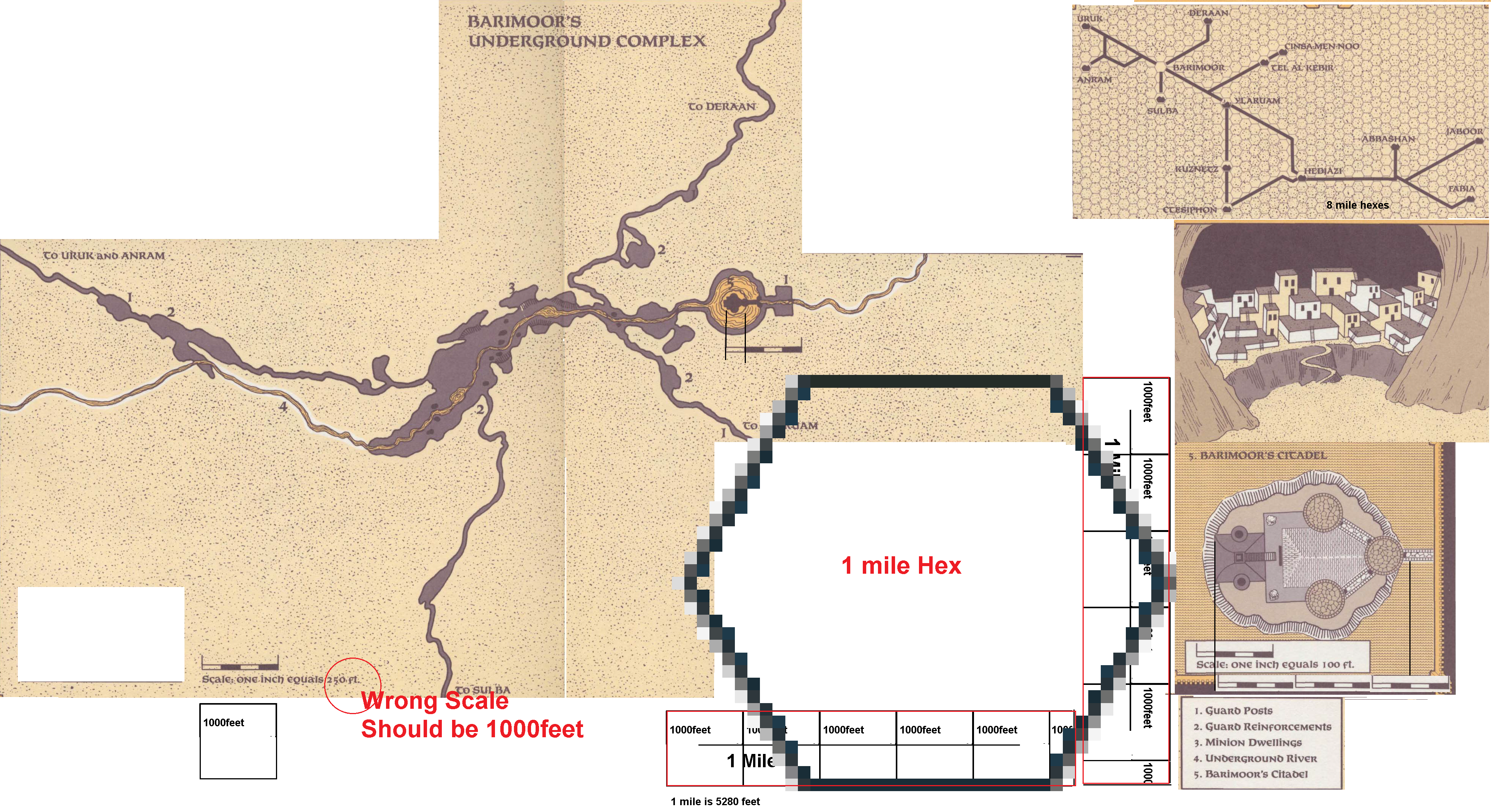
Ok about 2 years ago I began researching the Barimoor map, in a (later proved to be feeble) attempt to enable a map overlap of the caves to be made.
So I merged the material together in this copied map from Gazetteer 2 Emirates of Ylaruam. and this should be revealed as all my maps and research maps. so here it is. enjoy
First discovery the castle map is 100 feet scale, making the castle 250 feet large.
Second discovery the large cave map uses a 250 feet scale, and revealing this the castle is only 25% of that map... That is a serious discrepancy
First and most important resolve. The castle scales is assumed to be correct(looking at the structure's architecture and placement). This makes thge cave map scale to be wrong.Ā
Using this statement and measuring and calculating the finds, the castle on the cave map is 25% of the cave map scale...when the castle is 250 feet, the cave map scale should give the same size....making the overall cave map scale instead 250 feet,to be 1000 feet instead.Ā
As a mile is 5280 feet, Measuring carefully, I succeeded to impose a 1 mile hex in the scale, which makes Barimoor in total two miles long, and a mere 1000 feet or so wide
Ok the map, extremely small, is now increased in size by 200%, yet still it would not really be visible on the 8 mile hexes, and not really important on the 1 mile maps of my own.
So the general tunnels map, in the upper right corner is all required, and usable just for determining the genral tunnes...and no overlay map can be created (or is required) for the bBarimoor tunnels to be used.ĀĀ
Other caves and tunnels important fall into the same small scale (like Cynidicea) and thus I refrain from creating an overlay map with these caves, and stay to my general underground symbols instead, that is what this research gave me.
Geologically when looking at the given map these caves are water created caves, and the flow is gravitional erosion, with collapased areas(see settlements piture) due removed mass (either by waterand partially by labour.
As my resaerch on the Mogrethian destroying Tidalwave, and the effects on the forming of the Ylari Bassin today, the region of Barimoor was accoding fanon Mogrethian maps a forested region, meaning at least part of the ground were saturated and had ground water. This, as well as pre-existing underground rivers (water from the glaciers pushing through nooks and crannies into the underground, eroding passages enabling 1000AC water still to flow there. Some of the 1000AC water would be singing ground water from the Mogrethian era added with amounts of precipitation water from the Nithian era (which still had normal weaterpatterns to begin with), yet these became lower and lower due the Nithians meddling with (still hidden) Fire Elemental gates responsible for the heat in Ylaruam 1000AC.
The precipitation was also decreased due the elven Magic to create the Canolbarth Forest and changing weather paterns in the process. This cmbined made Nithia and later Ylaruam a hot desert.
This can be resolved in the future by closing these gates. And these could be quests for Ylari PC heroes