
De Glace and Hightower
by Robin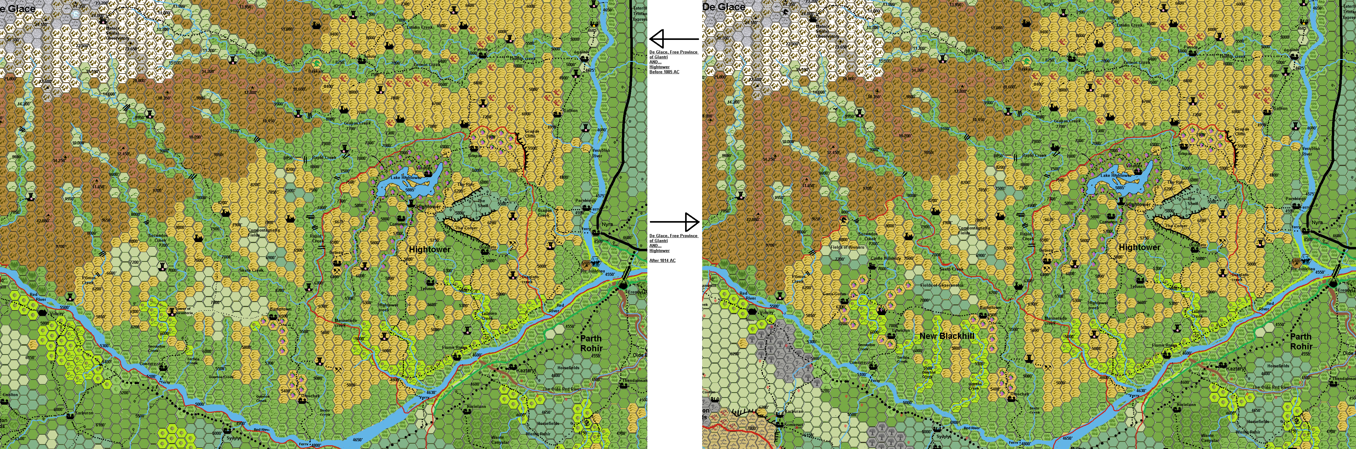
Depicting BEFORE the Meteor impact, in 1005 AC, and AFTER the meteor impact, in 1014 AC
De Glace, Free Province of Glantri
The Glantrian Alps, along with the Colossus Mounts are the most inhospitable mountains in Glantri. Fewer people reside in the Alps than any of other of Glantri’s mountainous regions. What little natural resources that come from the Alps are various fine furs and occasional monsters captured to be sold at the Capital.
Area: 4,088 sq. miles
Population: 5,384
Ethnic Groups: Thyatian 50%, Flaemish 10%, Boldavian 10%, Averoignian 10%, Erewan Elf 5%, Belcadiz Elf 5%, Belcadiz Human 5%, Alphatian 5%
Government: Propraetor appointed by the Council of Princes, in charge for seven years. Seat in Parabiago. Propraetor Tegus Borjigin (born 963, F12, AL- Neutral) Appointed in AC 1013. Last Propaetor Lucas Escepius (born 961 F13, ALCN)
House: not aligned to any house.
Territory: The Mt. Glace Free Province consists of the hills to the west of the Vesubian river to the south of Glantri City and between the Isoile and Red Rivers. The GFP also includes the eastern half of the Glantrian Alps. After the war, the southern section is lost to Blackhill.
Food: Sufficient
Towns: None
Selected Villages:
Parabiago (524) is located on the west bank of the confluence of the Red and Vesubian Rivers opposite the towns of Nyra and Erendyl. A ferry crossing connects Parabiago and Nyra. Parabiago is the largest settlement in the GFP (Glace Free Province) and is the capital and seat of the Free Province. Parabiago is the only real settlement of note left today in the GFP. It was heavily damaged during the Great War but ultimately spared as Thar’s main force was heavily engaged to the northeast in the Duchy of Hightower with the Glantrian army sent to relieve Blackhill. Much of the damage caused by the raiding humanoids has been repaired including the only notable site within the town, the Alexander Glantri Memorial Ferry which crosses the Vesubian River to Nyra. Parabiago is half the size it was before the war when it counted nearly 1200 residents. Many of the residents of the village actually prefer the way things are now; they have taken up larger residences in town and enjoy the peace and quiet of a midsized Glantrian village.
Concorezzo altitude 5100’(134/412) is a small village approximately 32 miles southwest of Hightower, just north of the Red River and connected to the Ferry there. The village has been completely rebuilt after being destroyed during Thar’s invasion. The village serves the isolated homesteads and towers that dot the barren hills of the Free Province.
Bartertown; Altitude 6500’ (125/210) provide basic services for the isolated homesteads and towers of the region.
Omocheck Altitude 5325’ (141/199) provide basic services for the isolated homesteads and towers of the region.
There are some other smaller settlements, with less than 100 residents in the region.
Gallion, Patrice, Salute, and égalité each with between 30 to 60 inhabitants.
Water
Vesubian River (Celon Vesubian) The 400’wide Vesubian River is navigable to river traffic from Glantri City to Trintan and sees heavy ship and boat traffic, especially in the winter months, moving trade and goods to and from Glantri City from the warehouses of Trintan. The elves of Erewan, have altered the course of this river by using the principle of Darokinian river dikes (summer (low dikes to keep the course of the river as desired) and the Winter dikes (to prevent flooding) forming the Current Vesubian River. The Vesubian River have reed covered shores and as such reed roofed houses are common along this river, in the city and beyond.
Red River (Celon Caran) The 200-430 feet wide Red river is navigable along it’s whole length along the northern edge of Erewan. The elves of Erewan, have altered the course of this river by using the principle of Darokinian river dikes (summer (low dikes to keep the course of the river as desired) and the Winter dikes (to prevent flooding) to form the Current Red River. The Red River have reed covered shores and as such reed roofed houses are common along this river, in the city and beyond.
The Red River is navigable along its lengths along the edges of Erewan and are heavily used for commerce and transportation. Many ferries croos this river.
Rapid Creek; From Mount De Glace to Sexto Creek. (West Border of Hightower)
Primos Creek; From Mount De Glace to Red River.
Secundos Creek From Mount De Glace to Red River.
Tertios Creek; From the Hills to red River
Quartos Creek: From the Hills to red River
Quintos Creek; From the Hills to red River
Sexto creek; From Mount De Glace to Red River.
Grapas Creek; From Mount De Glace to Vesubian River. Together with the Grapas Cliffs they form the Northern border of Hightower.
Termin Creek; From Mount De Glace to Vesubian River. Guide to main trail to Matera observatory.
Estalin Creek; From Mount De Glace to Vesubian River.
Trails:
The area of the GFP is some of the most isolated in Glantri. No major trails run through the territory. Numerous small poorly maintained trails link the small communities, and many more trails have eroded away or taken over by nature ofter not using them.. The GFP is a favorite of those who want to be left in peace and the Propraetors have respected the wishes of the people and not attempted to improve trails in the region. The lack of trails keeps travelers and caravan traffic on the east side of the Vesubian River and south side of the Red River.
Nyra ferry; 2 wagon ferry. 1 sp/leg-wheel. Main trail to Hightower.
Parabiago ferry; 1 wagon ferry. 1 sp/leg-wheel. Secondary trail to Hightower, direct trail to Parabiago.
Hightower-Erewan Ferry; 1 wagon ferry. 1 sp/leg-wheel. Main trail to Hightower
Eriadna Ferry; 1 wagon ferry. 1 sp/leg-wheel. Secondary trail to GFP
After 1014 AC Main Trail to New Blackhill; 2 wagon ferry. 3 sp/leg-wheel.
Concorezzo Ferry; 1 wagon ferry. 1 sp/leg-wheel. Secondary trail to GFP
After 1014 AC Main Trail to New Blackhill; 2 wagon ferry. 3 sp/leg-wheel.
Notable Sites:
Mt. De Glace is the highest peak in all of Glantri, and of the whole southeast corner of Brun. Often shrouded in clouds with glaciers covering it's slopes. It is the destination of three sorts of people. The extreme sports mountain climber who has no desire to grow old, the adventurer in search of arctic high altitude horrors that also has no desire to live to old age, and occasional scholars from Glantri (often in cahoots with the first two groups) who try to study the unique environment of Mt De Glace and the dangerous inhabitants of the mountain.
Matera Stellar Observatory altitude 24.000’ (population 84 scientist-mages and students). This large strangely shaped fortress-like structure is in fact Glantrians best source of planetary and celestial information. The long and dangerous trail towards the Observatory is passing the lair of Bakkarr, a mage large Green Dragon, who always enforces taxation in one form or another. When adventurers or troops are sent, not even its lair could be found, let alone Bakkarr itself. He must be aware of inside tactical information up to the higher ranks, but how, who, or even the why is unknown. Dracologists are always killed by Bakkarr. And of the few ruined towers in the region some are proof of this. In effect Bakkarr roams over the whole area Southwest of Glantri –city halfway up to Mount De Glace and to the border of Hightower.
Ruins; North of égalité are some ruins. These are forgotten by millenia, and predate the Great Rain of Fire. It was a settlement from the Blackmoor Colony in this region, and is currently so severely eroded, plundered, overgrown that near to nobody knows what these stacks of stones once were. There might be some forgotten cellars, but except from old useless tools and furniture, nothing of interest can be found. The region is plundered with the use of magic extensivly, and nothing of value remains. However, information, like decrepit papers(plastic-covered), books and obscure tools can be found. (These might have been technological like a drill, automated saw, solder equipment, things nobody will recognize in these days, nor see the usefullness in it, let alone be it still functionable...yet it could tell some information on those living here earlier.).
Compostagnella Field; This flat area west of Rapid Creek is in use by a few farmers using special magic to enhance produce. The results are unknown as of 1014 AC, as the war derailed the project. But all plants are three to 4 sizes larger than normal, so produce is estimated at least a 25% increase. However, dangerous plants seem to be attracted to the region too (Like Killer Vines, Vampire Rose, Archer Bush, etc.).
Omochek Mines; These mines go deep and cover a vast area of natural crevices and tunnels stretching up to 40 miles North and West, and 5 to ten miles east. The system is about 3 levels (at -250’, -450’ and 510’), beyond the dug two-level mine in the packed earth (-45’and ON the rock below at -110’), with a few smaller sub levels in between (DM; these sublevels are rarely more than a 100’x100’ The first dug levels are 200’long and 300’wide at best). All these caves are mined for rare ores. The rock itself is incredibly tough and contains high amounts of lead, so magic does NOT penetrate it. The miners just enter the caves and remove ore discovered in the walls by arduous work. Sometimes a mage tries to work its magic, but this only scratches the surface. There are Hulkers below, but these do NOT dig through the rock, they may however be forced/lured up by PC actions and create a cosy environment in the dug mine area. Ores found; Amethyst, Magnesium, Thungsten, Crystals growth, and some silver. The mines has its own internal Guard force of 40 level 4-8th fighters under command of Sergeant Baroll (often drunk the CN, normally NG, F14).
Die Jungfrau; A peculiar rock outcropping, with an even more peculiar story. Legends say that a mermaid lives here to sink vessels. Indeed there are often sunk vessels here, but these are mostly removed within a fortnight. How they got sunk is still unknown. Sometimes a nude female cloud or storm giant can be seen, but when approached she fades away. DM; The following text is hidden and may only be viewed by Dungeon Masters!! The Giantess does exist, but she is nothing more than a HUGE Ghost. She had responsibility for a ceremonial wedding dagger (According giant traditions a dagger is gifted over the generations over the female bloodline to be given to the male), but when travelling over this rock in 1700 BC, when the Disaster which shaped the Broken Lands came to be. Shocked she lost the dagger in the water, buried deep in the muck below. She searched and searched, wounded as she was, until her last essence of life slipped away. Bound to her duty she became a ghost, trying to lure others in retrieving the dagger. If adventurers locate the dagger, the ghost will be grateful, and give the characters one single wish which will be fulfilled if no magic is needed.
The rock is also used by boisterous youth of Erewan or nearby farms in a daring diving contest. They have never discovered the dagger, but have encountered the Hulkers. The also plunder sunken ships before guards come, and thus may be a hinder to the PC’s, who must not kill these citizens.
The dagger is in size equal to a 2 handed sword, in weight; add 50%, in value; as it was a decorated ceremonial dagger made of ancient mammoth bone and steel and due its age it is valued at 150.000gp (to any giant x3, to cloud/storm giants valued at 1.000.000 if recognized), in combat use -1THAC0/dm due awkward giant shaped hilt, but able to give a Luck spell once a day, A continuous Bless if LN, LG, NG, or even CG in alignment. If returned to a Storm or Cloud Giant it will be 75% chance be recognized as the ceremonial wedding dagger of the Bromdignags lost 2700 years or so ago— and honour and gratitude of the giants will be earned. As long as the character lives, the giant family will be willing to help him in his ordeals (not at severe risk without cost of course).
Why do the vessels sink? Because of a group of Umber Hulks living underneath the muck unhindered by the water, push the sword regularly up and aside in their muck tunnels, thus causing the blade to harm the vessel passing by, forcing the sword back in the muck, until the Umber Hulks are hindered by it again. If this is removed the Glantrian Chamber of Commerce and Travel will grant the heroes anything in amount of 75.000 gold (though it may take a while/difficulty to acquire) as reward. Of course this is an adventure for heroes of 20th or higher in level. And the DM may add anything below (or even dimensional) to increase the difficulty.
After 1010 AC
There are some important changes to this region when the Southern part is officially taken over by Blackhill, which suffered greatly due the impact of the meteor. As thus many inhabitants resettled here. And with Dolores Hillsbury in control, new names are introduced. More about this in the Blackhill section. The Tower of Zorasteria is partially damaged, and she and her cat have fled elsewhere or are dead. A huge black dragon darker then normal attacked the tower, locals tell. The tower of Zorasteria (M9) was typical of the residents of the GFP. Her tower was a typical wizard’s keep, much like the one illustrated in book ‘TSR 9208 - GAZ3 - The Principalities of Glantri.
Ruins;The region is dotted with mage towers, several of these are since the war (1004-1009 AC) abandoned, and some even prior to this. The reasons are variable.
Hightower, Principality of Glantri
Not much is known about the canon barony of Hightower. The following come from the 1 mile hex map.
Area: roughly 500 sq. miles
Population: 2200
Ethnic Groups:
Thyatian 50%, Flaemish 10%, Boldavian 10%, Averoignian 10%, Erewan Elf 5%, Belcadiz Elf 5%, Belcadiz Human 5%, Alphatian 5%
Government: unknown to author
House: not aligned to any house.
Territory:
The Barony of Hightower borders on the western side by use of the Rapid Creek the GFP. In the North along the Grapas Creek and Grapas Cliffs the border lies again with the GFP. The small section east of Hightower, bordered from the Graps cliffs, Grapas Creek, over the Hills to the Oragiato Creek. The Southern border is the Red River. Taxed by Hightower
Food: Sufficient, Produce Wines, grapes, Olive, Oranges, Lemon, Cherry. Known for its variety in marmalades.(its main export good).
Towns:
Hightower; altitude 5885’ (810/790) at Lake Hightower. Fishing, Wine/grape produce, hunting, and cattle farm (milk and cheese—meat only after high end life) between the Corner and the Rim.
Selected Villages:
Consome; altitude 5730’(110/145) Wine produce, hunting, berries produce
Telusen; altitude 5600’ (155/121) Grain, Cabbage, Salad and orange produce
Oragiato; altitude 5800’ (129/110) Grain, corn, and cabbage produce, Mining sand & Glass production.
Grapas; altitude 6333’ (235/245) Grapes, Wine produce, some river fishing, and logging
Demen; altitude 6420’ (155/150) pine logging, Mining sand & Glass production
Vinatida; altitude 6290’ (180/194) Fishing, and wine produce
Fiume Rosso; altitude 4630’ (123/90), Small Harbor (2 medium river vessel only), orange/lemon and olive produce, Reet produce, thatching. Trade
Water
Red River (Celon Caran) The 200-430 feet wide Red river is navigable along it’s whole length along the northern edge of Erewan. The elves of Erewan, have altered the course of this river by using the principle of Darokinian river dikes (summer (low dikes to keep the course of the river as desired) and the Winter dikes (to prevent flooding) to form the Current Red River. The Red River have reed covered shores and as such reed roofed houses are common along this river, in the city and beyond.
The Red River is navigable along its lengths along the edges of Erewan and are heavily used for commerce and transportation. Many ferries croos this river.
Rapid Creek;From Mount De Glace to Sexto creek
Marmelade Creek; From Lake Hightower to Red River. Widens the last 5 miles to 600’width, but depth 1-4 feet only
Hightower creek; From Lake Hightower to Red River.
Telusen Creek; From Hightower Central hills to Red River.
Oragiato creek; From the backend of “The corner”hills to Red River, popluted river due glass production and from the one mage tower.
Grapas Creek; From Mount De Glace to Vesubian River
Lake Hightower; Large freshwater lake, source water from underground streams melting water from Mount De Glace. Seasonal depth between Spring/Summer 120’ to 135’ in Fall/Winter. Carp, eel, trout, introduced naturally or brought in by fishers. Many small fish., also otters live here and are hunted for fur and meat(also in Marmelade- and Hightower Creeks). A few empty islands; From large to small; Chantue Rock, Elisa Rock, Otter Rock, Pecunia Rock (SW), Pillar Rock (SE)…the last is a single stone crystal which increases in size each year by an inch in diameter, and a foot in length. (current 121 inch diameter, 129’in length.
Trails:
The Nyra-Grapas-Vinatida Demen Trail, The Nyra-Hightower Trail, The Hightower ferry Trail, The Red River Trail and The Hightower Mid Trail All these trails are patrolled, and reasonably well kept, but often irregular, sandy, muddy, to gravel or rocky. There is no consistency in functionality and effect of these trails. As thus they are NOT taxed. Numerous small poorly maintained trails link the small communities, and beyond the region. Some are eroded away or taken over by nature after not using them. The lack of trustworthy and safe trails keeps most travellers and caravan traffic on the east side of the Vesubian River and south side of the Red River.
Unlike the GFP, Hightower’s mage towers are not isolated and a part of the community, and must thus take their responsibilities as such. Currently there is some conflict with Mage Kummer (An Alchemist) on Oragiato creek which causes often toxic pollution in the creek, and the elves of Erewan complain the dead fish once in a while floating by. The problem is, this alchemist knows the secret to specific kinds of glass production for lens making, which are highly desired anywhere in the Principality, and thus though while grinding teeth, they can only accept the pollution popping up once a while.
Nyra ferry; 2 wagon ferry. 1 sp/leg-wheel. Main trail to Hightower.
Parabiago ferry; 1 wagon ferry. 1 sp/leg-wheel. Secondary trail to Hightower, direct trail to Parabiago.
Hightower-Erewan Ferry; 1 wagon ferry. 1 sp/leg-wheel. Main trail to Hightower
Other Locations
The Shelf, The Rim, The Corner; it is believed that this area has been a lake too, connected with the Telusen fields. As it is also suggested Lake Hightower was larger covering Consome Fields too. Sages think the fertile ground are remnants from this lake, which was destroyed in 1700 BC, during the Great Disaster in the Broken Lands. All the water flowed down bringing fertile clay to the hills (and into the lower Rivers). Oragiato fields, Telsen Fields, Consome Fields and the Shelf are reasonably flat areas, used extensively for farming.
Grapas Cliffs; The 1700 BC disaster caused these hills to break up, slide down and create these 400 orso high cliffs. Many pigeon swallow and other birds nest here, and pigeons are used for egg produce, and meat.