
Locations in the Five Shires
by RobinWorking on the 1mile hex map I unearthed some material
Originally written for the Euro Gencon 1995 Championship of TSR/RPGA for all gamers in the world.
Made end 1994 by hand on preprinted parchent-alike paper
I found these maps in my files, and even if I had updated the Revenge of the Little Ones Adventure from the remaining material in 2014
I had not released the inside maps seperately
Yet now I work on the 5Shire 1 mile hex map, I find the information more than interesting to be released as such.
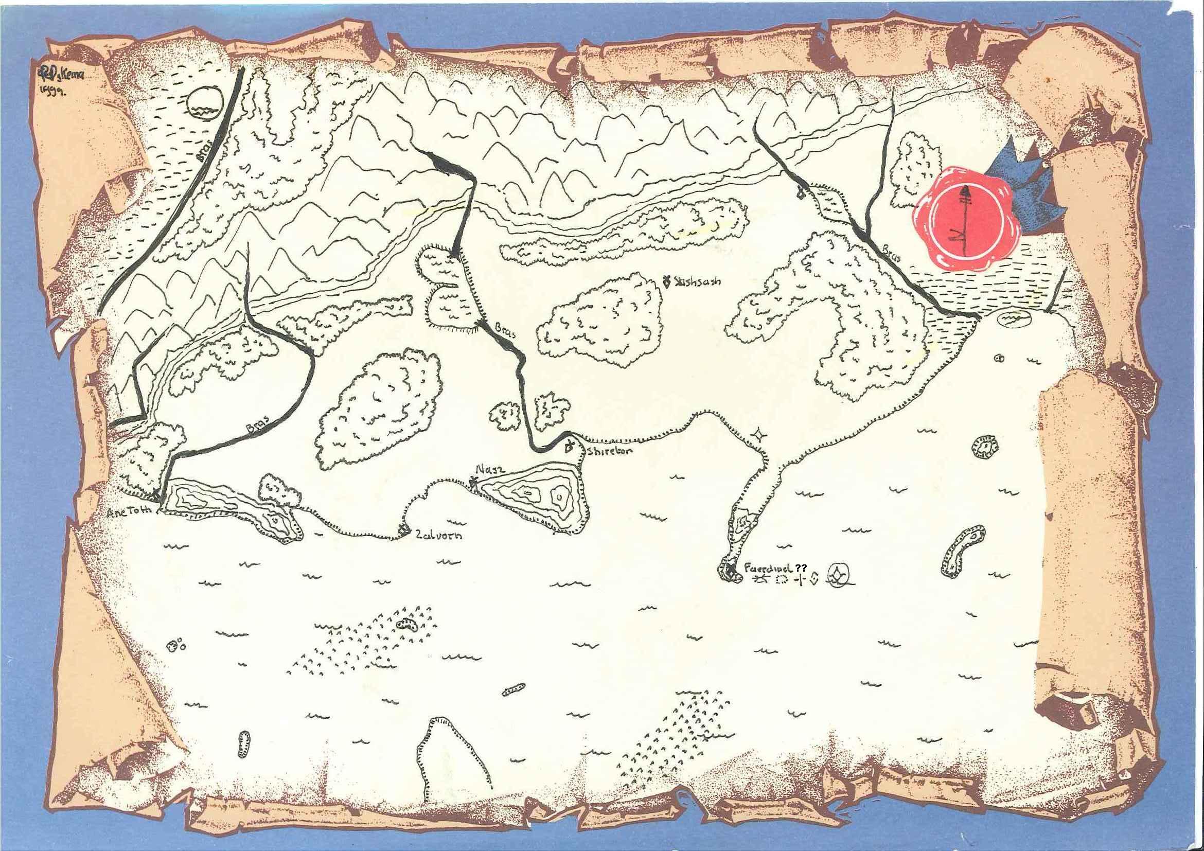
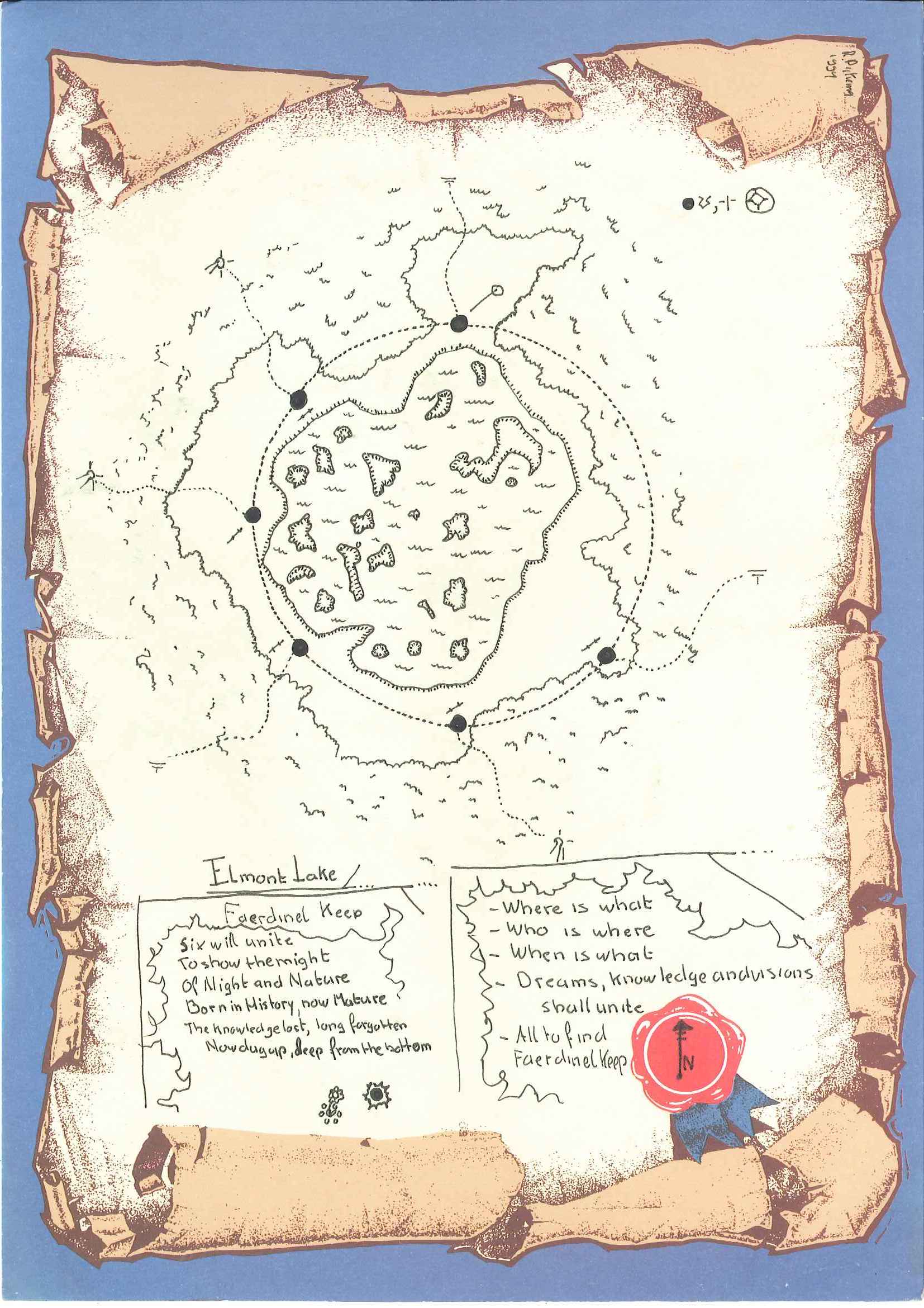
The only map I will not release here yet is the Solution of the Riddle map, You will find that in the DM section of the Revenge of the Little Ones Adventure itself. also because that is in fact the Orlin Isle central map, with just the riddle explained in lines on the map.
Apparently due this Official BECMI D&D Mystara Tournament the material is Semi-Canon instead pure Fanon
So...that makes Faerdinel placed at Orlin Isle ...sort of Canon???
Not completely, it offers the possibility, as even the map (supposed to have been created by a Hin, an unknown period after the 1750BC/1700BC disaster where the last continental remnants fall victim to the sea) does place questions marks on the later Orlin Isle location as being Faerdinel Keep.
And the Text within the file has an added red note, points at fanon placement of Faerdinel at the Black Eagle Location,
So there has been a keep on this olde volcano, yet it may or may not have been Faerdinel Keep. Keep in mind the Attached rock peninsula has collapsed after wards, thus creating Orlin Isle, The volcano , may have not erupted, yet its last quake caused the penisula to disintegrate.
Another interesting aspect on this map is the settlements labelling; Not only is all written in Hin/Lalor Glyphs and Human lettering, the names vary.
So this map is after 1700BC, After Landfall of the Hin in 1300BC, before 0BC, and names were different...
Any more detailed suggestions on the date of this olde Hin map are more than welcome
My gut tells me somewhere before 1000BC, directing at Chimpman's 1000BC mapping works of the region, yet as we together try to tune our maps into a single source over time, this may vary.
| 1000BC | between 1700BC & 1000BC | 1000AC | Extra Information |
| Chimpman's maps | Revenge of the Little Ones map | Canon | combining all |
| Tot-Hed Maers | not on map | Tothmeer | Logical |
| Huhuiztol | Ane Toth | Bramblerose | Logical, temporarily controlled by Tothmeer |
| Tlayuyan | Ruins | Brookbank | Logical, build on Ruins |
| Tepoz | Zalvorn | Rundegos | Logical, expansion of older settlement, feeding on Sateeka former lake stream |
| Shadaur | Ruins | Shadowgate | Logical, build on Ruins |
| Unnamed | Ruins | Flagonford | Logical, build on Ruins |
| Moezetl | Shireton | Shireton | Logical,expanded on earlier buildings/canals/architecture |
| Rrarsh | Ruins | Nob's Boots | Logical, build on Ruins |
| Atl-Ek | Ruins | Bridle | Logical, build on Ruins |
| Yakalu | Ruins | Longflask | Logical, build on Ruins |
| Last Refuge | Ruins | non existing(not even Ruins) | wood buidings, gone over time |
| Unnamed | Ruins | Fishtickle Bridge | Logical, build on Ruins |
| Non Existing | Sashsash | Leafkindle | Logical,earlier name based on wet /swampy area-sound walking |
| Non Existing | Unnamed | Obur's Mimbur | Logical, canon mining area, later with Tower(Mimbur) |
| Non Existing | Non Existing | Moon Hill | Logical, later settlement, may have had earlier nonsettlement function |
| Non Existing | Non Existing | Thantabbar | Logical, later coastal settlement |
| Non Existing | Non Existing | Wereskalot | Logical, later settlement on Cruth River, after diverting River Ruined, and rebuild West |
| Non Existing | Non Existing | Mallowfern | Logical, later settlement |
| Non Existing | Non Existing | Aercruth | Logical, later settlement |
| Non Existing | Non Existing | Wardlystone | Logical, later settlement |
| Non Existing | Non Existing | Deepmoss | Logical, later settlement, forested and mossy, wet as per canon, by draining lake north |
| Non Existing | Non Existing | Sateeka | Logical, later settlement, only build after area was dry enough |
| Non Existing | Non Existing | Rattlecart | Logical, later settlement |
| Non Existing | Non Existing | Hinmeet | Logical, later settlement after opening Mountain Pass |
| Non Existing | Non Existing | Mar | Logical, later settlement, northern Expansion |
| Non Existing | Non Existing | Ringrise | Logical, later settlement, Henge?? |
| Non Existing | Non Existing | Stillpool | Logical, later settlement, probably a small lake nearby (1 to 4 miles in size) |
| Non Existing | Non Existing | Rollstone Keep | Logical, later settlement against Black Eagle Barony (suspected area of Faerdinel Keep) |
| not mapped | Unnamed Pensinsula | Seperated Orlin Isle & Gettlebest Rock | Orlin Isle Suspected area of Faerdinel Keep |
Compiling all the names together
Red is capital
Blue is possible Faerdinel Keep location
So we can see the Hin did a lot of expansion after 1000AC