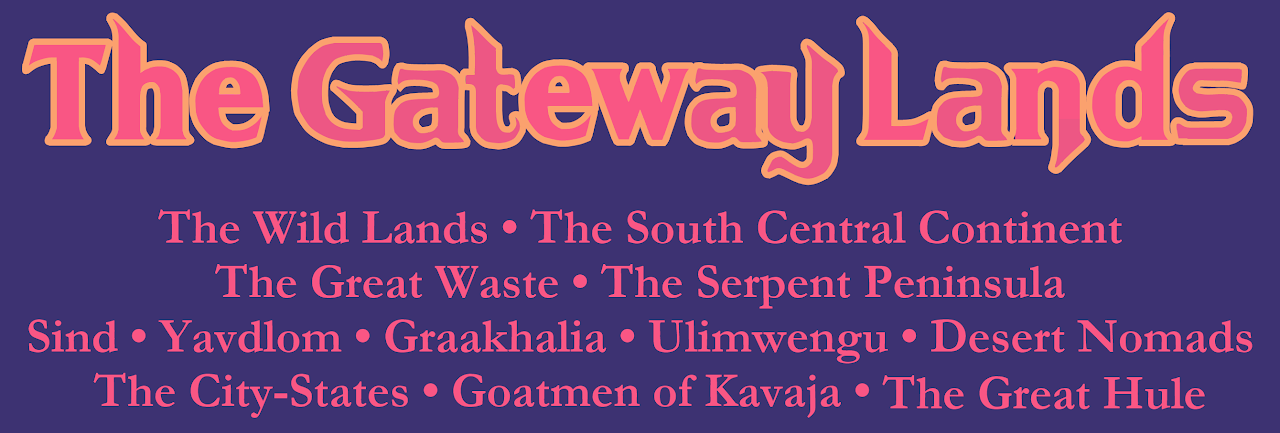
The Gateway Lands regionalization and logo
by Sionainn T. Mac InnéirgheHi, I've been studying the various Official "regionalization" schemes for the transitional lands which stand between the two "archetypal" Mystaran subsettings: the Known World and Savage Coast. And I designed a logo for that "transitional subsetting", which I call The Gateway Lands.
Here are the regionalization schemes I looked at:
***
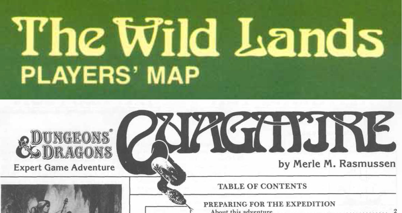
1984: X4 Quagmire! regionalization:
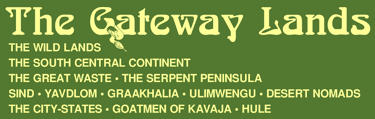
The Wild Lands (capitalized on map; not capitalized in text):
- South central continent (not capitalized at all in text):
- City of Slagovich
- Bush Country
- Sind Desert
- Burning Waste
- Barren Plain
- Serpent Peninsula
- Neck Grasslands
- River Hills
- Rain Forest
- Lagoon Lowlands
- The Fangs
- Serpent Keys
- Sea of Dread
- Shallow Sea
- Thangeia Island
- Sinking Keys
- Thangeian Swamp
- Thangeian Jungle
- Hill Country
- Western Thanegioth Archipelago
- Western Sea
***
1985: Mentzer/Froideval regions on Master Set world map:
Serpent Peninsula
In regard to the Master Set regions, Mentzer later stated: "At that time we envisioned that Empire to be the dominant socioeconomic and political force in that region, and thus the only one worthy of mention in the company of the other major/dominant forces in other areas. [...] The original concepts were quite vague, leaving the majority of development work to future authors."
So, the 1985-era conception was that the "Serpent Peninsula" was "quite vaguely" the major/dominant socioeconomic and political force in that region (including the Great Waste and Black Mountains, and even extending to the Adri Varma Plateau and the Hulean borderlands), and thus the only one worth of mention.
Yet I gotta say: if Rasmussen's already-published (1984) sinking Spiral City is the "major/dominant force" in that entire area, then it truly is a barren region!
***
1987: The rectangular regions from Dungeon Issue #6:
https://mystara.thorfmaps.com/dungeon6-brun/
Great Waste
Wild Lands
Hule
***
1993: CoM regionaliation -- the geographic hierarchy as presented in the table of contents and chapters within Champions of Mystara:
The Great Waste:
- Geography and Climate:
- The Sind Desert
- The Plain of Fire
- The Burning Waste
- The Barren Plain
- The Black Mountains
- Sind
- Jaibul
- Graakhalia
The Serpent Peninsula:
- Geography and Climate:
- The Konumtali Savannah
- The Nakakande Rain Forest
- The Okwonga Lowlands
- Dhiki Namazzi (Dire Straits)
- Thangeia Island
- Yavdlom
- Ulimwengu
***
1993: The "prominent areas" in the "Armies of the Great Waste" section (p.60-61) in CoM:
Sind
Yavdlom
Graakhalia
Ulimwengu
Desert Nomads
Note: the section header "Armies of the Great Waste" includes the Serpent Peninsula. In so, in one regionalization, the Great Waste is a short-hand term for both. Which is the opposite of the Master Set regionalization, where "Serpent Peninsula" includes the Great Waste!
Yet the intro paragraph of the Armies section further clarifies with a two-fold regionalization: "the most prominent areas of the Great Waste and the Serpent Peninsula."
BTW, I think its wrong that the Desert Nomads aren't on the map with a red lined "country." They're basically M-Afghans. X4 says it is their *home*:
"For years, the Great Waste to the west of the Republic has been the home of nomad raiders. Petty little tribes, both human and otherwise[.]"
So to sum up the regionalizations (not counting Hule):
One-fold regionalizations:
The Wild Lands (1984 Quagmire!) Includes the "south central continent" (what's later called the Great Waste) and the Serpent Peninsula, along with Thangeia Island, the Western Thanegioth Archipelago, and the surrounding seas.
Serpent Peninsula (1985: Master Set). The greater Mentzerian Serpent Peninsula.
Great Waste (1993: CoM Armies header). The nonce usage of the term "Great Waste" to include the Serpent Peninsula.
Two-fold regionalizations:
Great Waste + Wild Lands (1987 Dungeon mag rectangles)
Great Waste + Serpent Peninsula (1993 CoM chapter organization and Armies intro paragraph; note in CoM, the term "Serpent Peninsula" includes Thangeia Island and the Western Thanegioth Archipelago)
Which approximately correlates to the two land-divisions of the 1984 Wild Lands (not counting how Thangeia Island and the various seas were given their own entries):
south central continent + Serpent Peninsula (1984 Quagmire!)
***
Which means three terms: "The Wild Lands", "Serpent Peninsula", and "Great Waste" have Officially been used to refer to the entire region!
Which leads to one more regionalization...that seen in the Savage Coast Campaign Book (1996).
"Because most visitors to the Savage Coast come from the east or the north, I believe it behooves to first discuss the nations found there; while they are not a part of the Savage Coast, they serve as a sort of gateway for travelers entering the cursed lands. These gateway lands include Yavdlom, the City States, and Hule." p.13 (emphasis added)
The term "gateway" is also used specifically with Slagovich:
"At the region's far eastern end lies the city of Slagovich, often considered the gateway to the Savage Coast." p.8
Here's why I like the handle "Gateway Lands": (Note: I'm capitalizing it, though it was lower case in the text.)
Because it provides an Officially-sourced name for all the lands which are located between the two archetypal subsettings (KW and SC).
So we have KW, GL, and SC. :)
The Great Waste/South Central Continent and Serpent Peninsula (proper) have always been portrayed together. And Hule certainly played a big role in the Great Waste, as seen in the Desert Nomads series. As for the City-States, Slagovich first appeared on the Wild Lands map, so it has been connected with the Wild Lands subsetting from the start.
True, Hule *could* be developed as a distinct subsetting, possibly grouped with surrounding Midlands cultures and/or the City-States. And the Hule "rectangle" on the 1987 Dungeon mag map would support that. But the areas north and west of Hule don't yet have an Official treatment. Nor does Hule itself, really. Whereas the Gateway Lands do. And the "Gateway Lands" term from the 1996 Savage Coast does explicitly include Hule.
Also relevant:
Though Sind isn't listed as one of the "gateway lands" in the 1996 text, the word "Gateway" is a keyword for Sind. Sind's subtitle in CoM table of contents is "Sind: Gateway to the Eastern Lands." And the text explains that from another perspective, its also the "Gateway to the West."
Also of note: K:KoA (set in AC 1012), Sind has been "promoted" to become an integral part of the Known World proper. It's not only shown on the map -- its coat of arms is also displayed on the in-world heraldic chart of the KW which the Karameikos royal family had commissioned. Nevertheless, my logo and conception of the Gateway Lands includes Sind, since in Quagmire!, in the Desert Nomads series, and in Champions of Mystara, the area of (what was later named) Sind is the primary feature in the Great Waste. Perhaps the conceptual boundaries of regions changed in 1012 AC, but my logo is based more on the 1000 AC definition of the Known World.
And without further ado...the logo! :)

The logo is based on the fonts and colors (green and light yellow) of "The Wild Lands: Player's Map" label from Quagmire!
I used:
Boecklins Universe (freeware Arnold Boecklin)
Freesans Bold (freeware Helvetica)
Plus the snake from the Quagmire! title page, now on the G instead of the Q. (Which was a pretty spectacular font modification back in 1984!)
The subtitles are aligned to the left as seen in the Helvetica subtitle of The Wild Lands map: ("Player's Map")
***
What do you think and feel about the Gateway Lands logo?
P.S. A case could be made for the "gateway lands" to be split into two different subsettings:
1) The Wild Lands (Great Waste + Serpent Peninsula)
2) The Midlands(?) (Hule + City-States + the few Official indications on the Midlands, as gathered by LoZompatore)
But since Hule and the Midlands are barely filled out (from an Official perspective), at this point, I like the GATEWAY LANDS to serve as a diverse subsetting which is a peer of the KNOWN WORLD and SAVAGE COAST.
P.P.S. I included "Goatmen of Kavaja" as a realm, based on Bruce's write-up: The Goatmen of Kavaja
Patrick wrote:
I know I'm in the minority on this, but my introduction to this region came from the Champions of Mystara boxed set. And there's nothing in this logo to remind me of CoM.
What about this new variant I posted?