
Hulean Gaz, Chap 1: Geography
by Christian ConstantinGeographical Survey
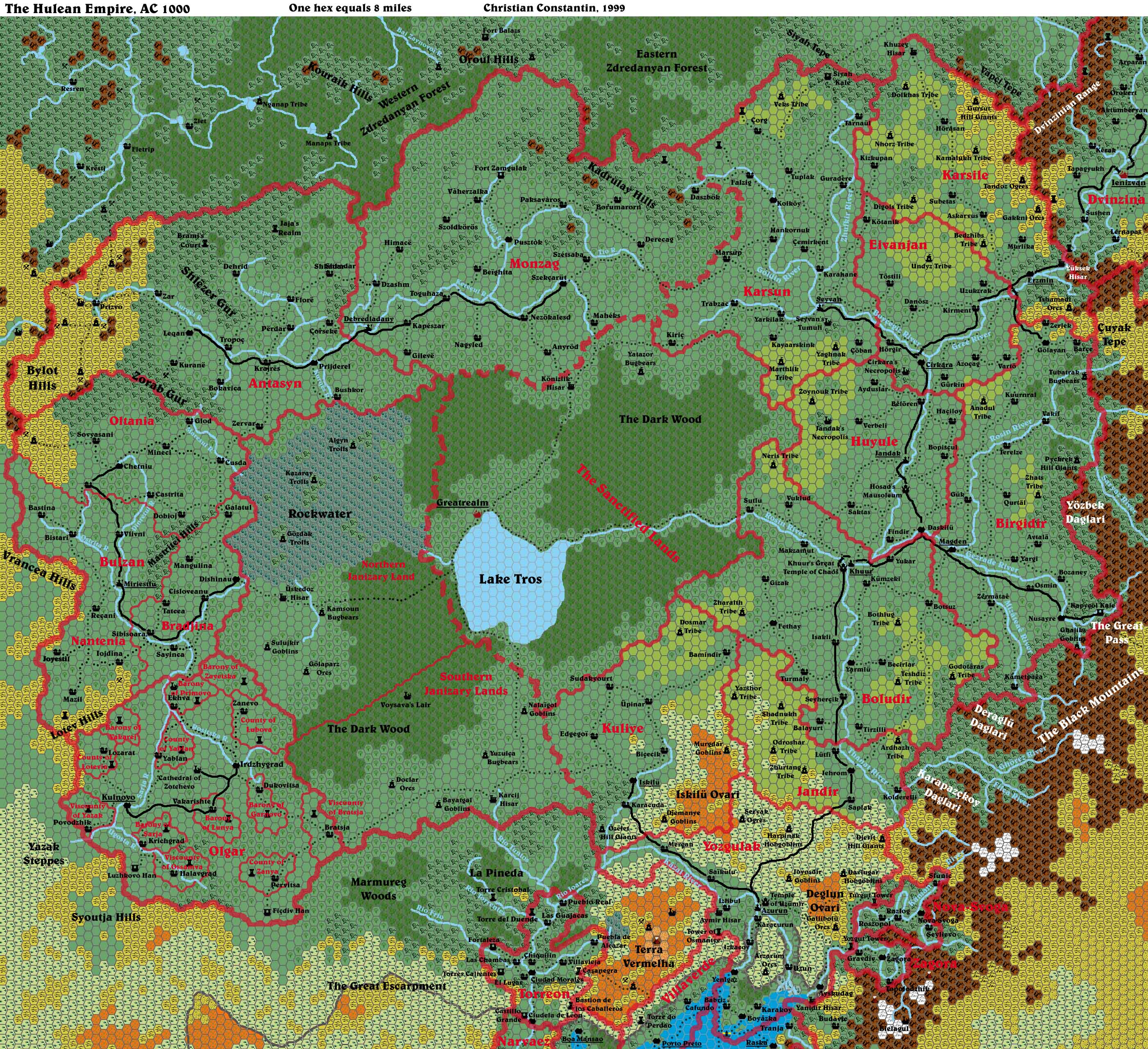
(For a 8 miles/hex map of the Empire.
Hule is a vast and diverse country. It stretches from the warm and salty waters of the Gulf of Hule to the cold and windswept Zdredanyan Forest. The Nine Kingdoms, the core of the Hulean Empire, are located on the eastern side of the Hulean Basin. This asymmetric bowl-shaped depression, extends from the Black Mountains' foothills in the east to the Bylot Hills to the west, and from the Great Escarpment in the south to the hills of the Zdredanyan forest in the north. The centre, and lowest point of the Hulean Basin lies somewhere between the Rockwater marshes and Lake Tros. Therefore, the eastern side of it is somewhat larger and flatter than the western side. On this steeper western side are located Hule's principal colonies, the Converted Lands. Many rivers take shape in the higher regions and flow into the basin, attracting many different peoples and fauna as well as giving rise to a wide range of flora.
Hule itself - the Nine Kingdoms, the eastern side of the basin- consists primarily of flat rolling hills and large valleys. The arable lands are plenty but many are a little more than steppes since they are devoted to semi-nomadic herding and small scale cultures. The valleys tend to be heavily settled, while the higher lands are left to the semi-nomadic humans and to the humanoid tribes.
The climate is drier in the southern part of the country, where the Great Escarpment reaches its highest point, than in the northern part, which receives the cold and humid winds of Brun's hinterland during winters. Due to the lack of rain during the winter months and the porous bedrock, the southern part of Hule is distinguished from the rest of the land by its rocky steppes and its semi-deserted badlands.
The Mountains
The Black Mountains dominate Hule's eastern frontier. They are some of the tallest and most dangerous mountains anywhere on Mystara. Many of the mountain range's peaks are permanently snow covered, and large glaciers fill the higher valleys. The Hulean side's foothills are heavily forested in contrast to the side facing the Sind Desert. However, at altitudes of over 12,000', only the grasses and lichens of tundra terrain cling to survival. Peaks reaching higher than 15,000' in altitude (of which there are many in the Black Mountains] present nothing but bare rock to wind and sky.
The Karapazçkoy and Deraglü Daglari (Karapazçkoy and Deraglü Ranges) are small westward extensions of the Black Mountains. These ranges are smaller and have eroded more than the main chain since they are more exposed to the winds coming from southern Hulean steppes and to the heavy rainfalls rolling in from the Gulf of Hule during summers. The highest peaks of these ranges can reach 15,000', but the average is around 7,500'. As with the rest of the Black Mountains, the Karapazçkoy and Deraglü Ranges, are made mostly of gneiss even though the erosion has brought the underlying granite back to the surface. The two ranges are embedded in forested hills, which give way to the precipitous Ghörez and Filça rivers' valleys.
The Yözbek Daglari is like a row of swords planted into the foothills of the Black Mountains. It forms the western wall of the River Saryaz canyon and its peaks are as high as they are in the rest of Black Mountain Chain. The Yözbek Daglari is a common sight for anybody leaving Hule since it closes the northern side of the Great Pass.
Climate: The Hulean side of the Black Mountains is much more humid than the eastern side facing the Sind Desert. If the foothills have a temperate climate, the higher valleys are icy cold during much of the year since temperatures drop approximately 4ºF for every 1,000' increase in altitude. One could say that there are only two seasons in these harsh regions: spring and winter. Indeed, the Mountains' fall, winter and spring are all very cold and snowy while summer, which may last only two or three weeks around the highest summits, is mild at best.
Terrain: The high mountains, steep cliffs, and rocky slopes of the Black Mountains make them uninhabitable for most living creatures. Travel through the Black Mountains is nearly impossible, except via certain passes and trails. Travellers confront food scarcity, snow-covered crevasses, avalanches, cunning monsters, freezing cold, and air so thin it makes breathing difficult.
Few mineral resources have been found in the Black Mountains, and if there were, their exploitation would be more than risky and would turn back even the most hardy dwarf.
Population: Orcs, ogres, kobold, goblins, hobgoblins, gnolls and bugbears all live in the caves and wild lands of the mountains and foothills. Less common intelligent inhabitants include mountain giants, a few scattered and beleaguered dwarven colonies and some dragons. Monsters and creatures with some affection for cold, arid or airy territories can be found throughout the Black Mountains. Only, in the southern part of the range, will one find human settlements, and those settlements are confined to the valleys cutting into the Black Mountains.
Hills and foothills
Most of Hule's frontiers are drawn in hilly terrain, some of them forested, others semi-arid or cultivated. The foothills of the Black Mountains are as high as many other mountain ranges elsewhere on Mystara. They are mostly covered by primeval vegetation but many expose bare summits. Numerous small streams cut through the landscape of the Black Mountains' foothills where they merge into bigger rivers flowing toward the centre of the Hulean Basin. Those small streams and rivers flow into mighty canyons with precipitous cliffs and only near the basin's edge do the valleys widen.
Karcij Tepe, at the southwestern end of Hule are completely different, they are small rolling hills covered with leafy trees, with a thick cover of pine near the summits. Small rivers and streams flowing from the natural sources of the region are common and flow peacefully toward the bigger rivers of the Savage Baronies.
The Çuyak Tepe, at the border of Dvinzinia and Hule are formed by the conjunction of the foothills of the Black Mountains and those of the Dvinzinian Range. These high hills are rocky, only sparse grass and torn bushes are able to survive in the constant cold wind flowing down the slopes of the northern Black Mountains.
Vapçi and Siyah Tepe are two similar-looking hilly forests. These hills are the westernmost arm of the Black Mountains. They slowly give way to the higher hills of the Zdredanyan Forest. These are generally rolling hills with a higher summit here and there and are covered with a dense mix of primeval and leafy forest.
Climate: The northern hills and foothills mostly have a cold temperate climate with long chilly and humid winter, short and warmer fall and spring, and fair summer. The southern hills tend to be drier and receive much of their rain only during the heavy downpours in spring. Summers in the southern hills are dry and hot, fall is slightly colder while winter is relatively warm and punctuated by localised rain showers. The Çuyak hills are made more arid than the other northern hills by the constant winds blowing from the Black Mountains higher valleys.
Terrain: The foothills of the Black Mountains are characterised by steep slopes climbing rapidly from narrow forested valleys to bare summits. The streams and small rivers regularly jump from one level to another thus forming charming falls and cataracts, but also deadly sinkholes and cliffs. Travel occurs mainly through these narrow valleys, which are ideal ambush sites for the surrounding humanoid communities. The Master has forbade human settlement in the foothills and reserves the lands for his humanoid guests and troops. They make their living from trade in furs and timber, fishing and a little grazing.
The Karcij Hills are densely forested and represent a terrain slightly rougher than the neighbouring valleys and plains. However, settling there is made difficult by the dense forest and by the fact that these hills are the frontline between Hule and the Savage Baronies.
The Cuyak Tepe is rocky and inhospitable with steep slopes giving way to semi-desert valleys. The summits of these hills are tormented and eroded by the biting wind blowing from the mountains. Rocks are regularly detached from the highest points and rolls down into the lowest valleys. However, these hills are rich with mineral deposits (silver, copper and tin) that are exploited by small Hulean communities. Travel through the most remote parts of the Çuyak Hills is risky since water and food sources are scarce.
The northern forested hills are uneven and rolling. They do not represent a particular obstacle for anyone willing to cross them. In winter, though, the heavy snowfalls common in the region tend to make them nearly impassable.
Population: All the hills surrounding Hule are considered to be frontier lands and are placed under the responsibility of the military administration only to be given to the numerous humanoid tribes of Hule. Few humans would try to settle these lands since they are far from being the best lands for farming and the humanoids that hold most of them are far from friendly. Only the Çuyak Hills bear a larger human and dwarven population due to the mining activities carried out in the region. The Siyah hills are rumoured to harbour a small elven community battling the Master's authority in the region. All kinds of humanoids may be encountered in the Hulean Hills, where they tend to be seen in larger groups than anywhere else since the hills are clearly their territory. Monsters of almost any types can be found in the hills according to the particular type of land (rocky or forested) that they prefer.
The Great Escarpment and the Coastline
The southern part of the Hulean Basin rises gradually to form a plateau which ends abruptly at the latitude of the Gulf of Hule. There, following a fault line created by the telluric activity brought in the region by the explosion of a Blackmoorian device in modern-days Broken Lands, the altitude drops by nearly 2,000' into the lowlands of the Gulf of Hule in its easternmost part or by an average of 1,200' into the steppes of the Yazaks in its western portion. Telluric and volcanic activities are quite common along the Great Escarpment and well into the southern part of the Black Mountains. The Great Escarpment is only interrupted at four points: the Kâman River Canyon, the narrow valleys of the Tilkit and Kazâl Rivers, and the wider valley of the Rio Guadiana.
The highest point of the Southern Hulean Plateau which terminates at the Great Escarpment, isn't the edge of it. It can be found miles inland in the arid regions of Southern Hule. There, around 3,000', the lands are subject to terrible winds coming from the vast expanse of land known as the Yazak Steppes. The windswept lands found at the top of the Escarpment are not suitable for agriculture given the drastic temperature changes, porous soil unable to retain rain water, and the constantly eroding top soil giving way to bare rock in certain places. The only activity in these regions is herding and grazing, the northern slope of the plateau being renowned for the exceptional quality of its wool.
The highest region of the Plateau (Terra Vermelha, and the Deglun and Iskilü Ovari) are particularly arid. There, the joint action of heavy rainfall, porous sedimentary bedrock, and violent winds have carved the plateau into lone rocky towers, deep windy canyons, strangely-shaped hills and immense cave networks. Certain humanoid tribes dwell in this harsh land living like troglodytes in the natural caves or carving their houses directly into the soft rock. Some of them may even attribute supernatural powers to the more strange hills and revere them as sacred ground.
Hule's coastline consists of a small flat peninsula extending below the edge of the Great Escarpment. The Boyâzka Peninsula's altitude varies between sea level and 100' at the foot of the Great Escarpment. Small beaches and salty marshes punctuate the Hulean coastline. The shallow waters of the northern Gulf of Hule hinder the construction of deep sea ports and only in a few spots, often along rivers, is the water level deep enough for big vessels to land directly in the ports. Otherwise, in Boyâzka by example, ships must stop at some distance and shuttles are required to unload cargo and bring it in the city.
Climate: The climate of the Southern Hulean Plateau and of the edge of the Great Escarpment is warm and temperate, but extremely windy. Winters are cold and dry but relatively short. Springs bring heavy rainfalls from the Izondian Deep and the overall atmosphere is humid although the rain is rapidly absorbed into the water table. Summer days tend to be dry and hot, while the nights remain colder. Fall is a little colder than summer but it brings more rain.
Hule's coastline is a lot more humid than the interior. It is temperate, with a hot but somewhat dry summer, a warm and damp fall, a temperate winter and a very rainy spring. Springs may bring thunderstorms and hurricanes from the Izondian Deep.
Terrain: The Plateau is mainly covered by prairies with patches of lush grasslands. Forested lands may be found around the few rivers that flow in this region of Hule. Eighty percent of the plateau's population (in Hule) are located along the banks of the two main rivers, namely the Kâdan and Kâzal rivers, where the soils are able to retain some of their water while supplemented by the rich silt of the higher regions. Azurun is the only major town located on the plateau, Iskilü lying at the northern edge of it.
The flat lands facing the Gulf of Hule are densely forested and, only recently, did the Huleans begin to settle and exploit the region. Small fishing hamlets can be found everywhere along the coast while bigger cities can be found at the mouth of the region's rivers. Located on the shore of a large bay, Boyâzka is an exception. The Castle of Yanidir (Yanidir Hisar) is Hule's main military port, the gulf floor has been dredged to permit access to the docks for the huge Hulean war galleys.
Population: From 1-5 persons (mainly humanoids) per square mile in the arid highlands to 20-30 persons per square mile in the valleys and near the larger towns. Azurun dwarves any other settlements in the region with an impressive 32,600 souls. Wandering tribes of humanoids can be found throughout the plateau in the most desolated places, the Master have given them much autonomy on these lands. The lower northern slope of the plateau is inhabited by semi-nomadic clans of humans that came to Hule in one of the numerous invasions of this country's long history. Many geonid tribes can be found in the caves of the badlands.
The Hulean Coast is among the most densely populated region of the country with well over 20 people per square mile everywhere along the coast. In the deepest forest and in the rivers' delta, however, this proportion may rapidly fall to less than 5 people per square mile. Humanoids are few besides some raiders coming from the heights of the Escarpment. Foreigners are plenty in the Hulean ports to the opposite of the rest of the land.
The Dark Wood
The local people fear this large forest for it is rumoured to be haunted. Humans do not live in it and most of the non-humans beings (even the evil ones) avoid it. The most common trees of the forest are oak and aspen. The underbrush in this forest is very thick. Thorn bushes abound. Animals found in the wood include bear, boars, deer, small game, owls, crow, ravens, toads, and bats. People going into the wood always have the sense that these creatures watch them as they travel. Running waters in the forest are enchanted. There is a cumulative chance that one drinking this water will be transformed into a boar or a deer (the transformation occurs after four saving throws vs. Spells consecutive or not). Groups of skeletons patrol the skies of the forest aboard flying barges.
At the centre of the Dark Wood is Lake Tros, a large (4,500 sq. mi.) and seemingly bottomless freshwater lake. Greatrealm, the Master's capital city, lies on the shore of this lake. Greatrealm consists mainly of a vast temple complex built inside a walled compound. Fields tended by the temples' novices surround the land around the temple. A large path lined by the statues of the different deities revered by the Huleans links the Temple to the shore of Lake Tros. All the buildings are heavily decorated with statues, friezes, elaborate eaves, towers, banners, and paintings.
The Basin
The biggest share of Hule's territory is located on the western side of the Hulean Basin. In fact, it is made up of the large hydrographic basin of the Rosin River and its numerous tributaries. These rivers have carved out large valleys converging towards the centre of Hule where the Rosin River funnels toward Lake Tros. The lands of Hule are among the best agricultural lands on Brun, the valleys are enriched by tons of sediment torn out of the Black Mountains and Zdredanyan Hills. This basin is made up of five main valleys: the Boycegiz and Gree Rivers valleys in the north, the Rosin and Gezrâde Rivers valleys in the east, and the Thanat River valley to the south.
Climate: The climate of Hule's basin regions is temperate and made up of four distinct and similarly long seasons. Spring is mild and humid from the rainfalls brought from the Izondian Deep by the strong southern winds and from the snow thawing on the slopes of the Black Mountains. Summer is drier but regular thundershowers may form when temperatures stay high for long periods. Fall is more humid than summer, as the northern airflow brings the colder humid winds of Brun's hinterland. Winter is cold and humid while the northern winds blow, snowfalls are rare in the south but common in the north.
Terrain: The basin is a region of large rivers and valleys with some flat hills and many small woods. 70 percent of all Hulean humans live along the rivers. The highlands surrounding the valleys (depicted in yellowish green on the map) are dedicated to the semi-nomadic human tribes of Hule. A multitude of villages and small towns dot the landscape of the Basin and a few much bigger cities have bloomed at strategic locations. Most of Hule's trade and travel are done along the rivers either on small barges or on the paved roads that link the major Hulean cities. Almost every kind of cereals and vegetables are cultivated in Hule's irrigated fields and the rivers also provide plenty of freshwater fish.
Population: Human population ranges
from 20-30 people per square mile in the valleys to 10-15 in the
highlands. Many large towns can be found along the mighty Hulean
rivers. Jandak, Hule's bustling metropolis, with 52,600 inhabitants
and Khuur at 22,600 are the Basin's biggest centres. Many humanoids
live in the basin, but in contrast to their brethren in the more
remote regions of Hule, they do not administer their own lands and
are seldom organised in tribes.