
Thoughts on the Evolution of the Isle of Dread
by RobinOk Here are my research notes on the Isle of Dread (as I intend to make a 1 mile or half mile hex map of the island)
Several altitudes from the canon are thus clarified
I hope it helps
X1 page 1; tiny island -known to its natives only as the Isle of Dread.
Ahem, even with the hex-scale adjustments this island is far from being tiny.
X1 page 7;They may map 1 hex of terrain in every direction when they pass through a hex (7 new hexes maximum). If the terrain in the hex is mountainous or covered with dense foliage, the party's sight will be blocked, and mapping will bedifficult. In these instances, you must decide how many new hexes the characters are able to map.
In this moist, warm environment, it is best to make everything hazy and unclear with one hex distance visibility (be it 6, 4.3/8, or 4). So if on the edge of a hex you can see some details up to the far end of the next hex.
In rain half this, in fog your sight is limited to the fog
You can't see more than a 100 yard at best in vegeetation. Chance to get lost is as jungle
The large central Plataux towers over the island.
During night time it will be invisible unless within 2 hexes
Just after Sunrise clear sky, it will be very visible up to 6 hexes away, as vague haze without details. Some details might be visible in this unobstructed range if coming from the east due the sun brightly lighting the facade of the Plateux
The same applies during day clear sky approaching from the south , and just before sunset. All other areas of the plateaux reveal themselves as nothing more than a dark haze.
Sight between hills is 1 hex at best, as other hills and vegetation restrict vision. On a hill top the vosion is double that and may (depending on range) reveal the shape/location of the central Plateaux.
From anywhere below nothing can be seen on the plateaux other that flying creatures (which eagerly see and feed upon you)
X1 page 22; Bordered by mountains on one side and the great river canyon on the other is the central plateau. It stands separated from all else by steep, jagged cliffs rising 3,000 feet.
A dormant volcanic mountain dominates the plateau, and a crater lake lies at the center of the mountain. The volcano can be seen from nearly all points on the plateau.
This text is a bit confusing; either the Plateaux rises 3000' from the surrounding mountains, or it rises up to 3000' The last seems best suitable, making the edge of the Plateaux at roughly 3000' altitude (so high but not ridiculously high)
Secondly it labels the sides of the plateaux as cliffs, while rocksides would be better. As the area is described as a volcanic terrain, it (the whole island) is clearly shaped over a series of eruptions. See Below;
Thirdly it is not given how gigh the mountains and plateaux are to eachother. It can be estimated the mountains close to the plateaux aree abour 2000'-2500' high, caved in/eroded between the uppushed plateaux and flown away to form a river along the faultline, depositing eroded matter in the swamp. The eastern mountains must have a very steep side at the ocean as the rivers source there is only 1 hex away from the coast. The same/similar water source could explain this high yet possible origen.
This will place the whole east mountain part at an average 2500' (as the mountains were described lower than the plateaux.
This 'mere' 500' or so difference , (as the later dition canon text describing the bridge entering lower than the plateaux) would explain the possibility of a bridge. It also explains the Mantru inhabitants reqularly use (or have used) this bridge. And as such would insert the possibility of tunnels through the inner crater walls used for this. For else why would one build a magnificent feat without a reason. The inhabitant would thus most possibly be Tanaroan, with possibly some adventurer genetic influx from human adventurers staying there.
X1 Page 23; The cliffs surrounding the central volcanic lake form a high, imposing wall of upthrust rock. Often shrouded in low clouds, the
tops appear jagged, and in some places snow-covered. No clear trails are visible over the cliff wall, but it appears that the wall can be scaled in many places. Even characters without climbing skill may attempt to climb the cliffs, as there are obvious handholds and routes up the rock face.
...
It takes 12 hours of climbing time to reach the top of the cliffs.
No exact height of this crater wall is given, yet calculating according " You can climb somewhat more than 1,000 feet (305 meters) vertical in a day as long as you come back down and sleep at a lower altitude"
as 12 Hours is half a day, this states the near vertical outer Crater walls on top of the plateaux are roughly 500' higher than the Plateaux center edges. As the Plateaux edges are estimated accroding given canon at 3000', the centre would be about 3300' to enable a flow stream for water. This would then place the average top of the near vertical walls at 3800'
The canon statement that there is an 8hr climb down required, and referring to the Plateaux map using the same general width inner and outer wall, places the inner crater area against the wall at an average of 3300' and the lake water level at roughly 3200' enabling water from the center to flow through lava tunnels to the Plateaux's outside surface.
This water's origin is somewhat awkward, and it is suggested a Gate from the Plane of water exists inside the crater lake, or an upward draft from the Ocean must exist. This only would allow the formation of a stream enough to erode through the mountains.
The positioning of Lower Caves being most logical emtied Magma chambers regarding this is a canon (at least magma based) slumbering volcano, and the filling in of biological flora and fauna clearly states by possibility that this happen following the last major eruption. As 386 AC GAZ LJ1: The Sea of Dread states; Groups of kopru retreat into hiding in the tunnels beneath the Isle of Dread.
The canon encounter earthquakes state there is still volcanic activity, or at least seismic activity, and this is best explained by the Faultline, This would siphon away magma, while still from each geological movement would exist. (Northrn half + Plateaux up and shifting along a somewhat sinking southern half of the island.
Eruption history;
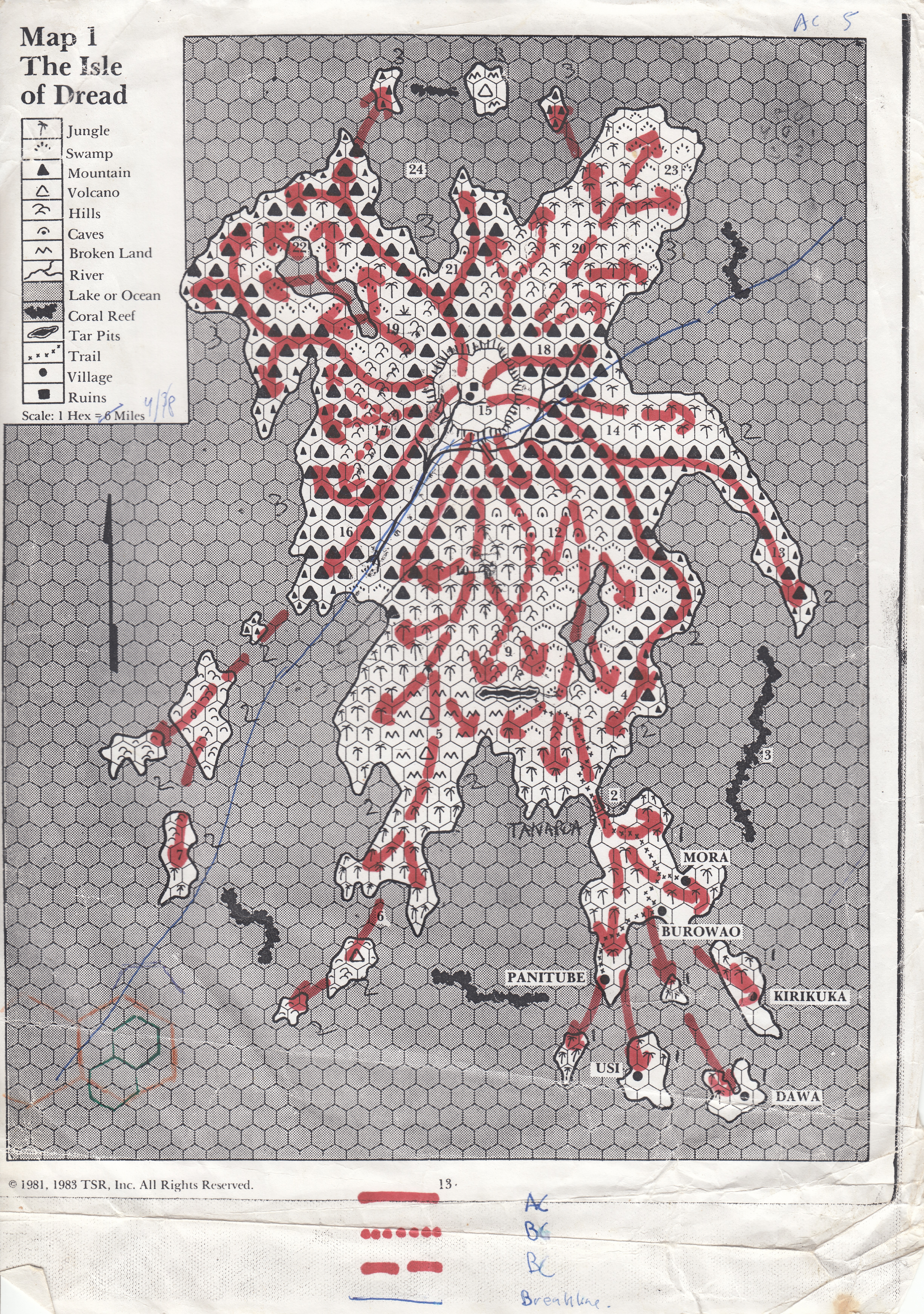
Here I used 3 major eruptions. AC, BC, and BC. As I had not been as deep immersed into Mystara history then when I made these maps... I did not use dates.
AC could be somewhere close to 0AC yet no later than 300AC, as the island then will have time to recover enough for the adventure locations build up.
The two BC dates could best be linked in to the 1750-1700BC series of earthquake disasters and continental sinking of the Taymoran coast and the GroF 3000BC. An third (unmentioned in my map) quake is described in 289 BC sinking Colhador, and would very well have had at least some effects on the Isle of Dread..
Following the GAZ LJ1: The Sea of Dread
In my game I tied the adventures of CM6-TSR9158-D&D-Mystara-Where Chaos Reigns into Mystara pre time line, the locals call Mystara alos, and placed the Dwarven Island (Anvil of the World) on the location of the future Isle of Dread preceding the great changes
Millenia later the island became the island of the Sorcerers (still preceding the Blackmoor era by several hundreds of years. This together will be a stable base for the Temporal distortions on the island as canon and fanon dictated. That said, that was my personal solution.
I will post my geological maps I made a few years later, based on this premise, using the canon I had, as soon as I can relocate them.
So we have
9.000 BC In the Beginning (my input) Th volcano is spawned yet still fully inderwater.
7.000-6.000 BC Anvil of the World. (My input). Series of minor eruptions broke the waves and created a small island, taken over by the first Dwarves 6.000BC creating the first Forge of Power enabling entering the Iron age.
5.500BC Bronze & Iron (My input) The island grows by a series of minor eruptions
4500-3800 BC Island of the Sorcerers (My input) The world is still called Aelos. Blackmoor is still a conflicting area of petty Kingdoms. The Island's volcano is in a rest phase, yet has grown on the Northern side (where the bibliotheca was). The magical experiments (beginning with the Oard time gates, and followed by mortal and Immortal) start affecting time, bringing beeasts from the pasts.
3000 BC GRoF Major Eruption (red broken line). Shaping the Island more towards as it is today.
between 3000-1700BC. Only minor eruptions and rising of the central Plateuax
1750-1700 BC. Major eruption (Red Dotted Line). Massive earthquakes,Breaking up of the 3000BC lava flows into seperate Islands, Spawning two minor Calderas. Rising the Plateaux even further upwards. Filling in the west and NE sections of the island between the firther Lava Flows.The Fault Line is greated. Massive Tsunamis From the North, as well South, as well as spawning Tsunamis itself around.
1700-289 BC. Earhquakes and further rising of the Island's North Part of the fault line. The Plateaux crater solidifies over time.
289 BC-300 AC Major lava flow eruption(Red Line), minor earthquakes. Flowing over the earlier lava deposits, shaping the today Mountains. Th Plateaux does rise anew as a new crater opens in the center of the Plateaux using empty Magma chambersbelow, filling most of these till eruption. The surface flowing magma creates lots of Lavatunnel terrain, and when th lava passes on and the tunnels harden, form several caves and tunnels on the island.
300-1000 AC. The Volcano slumbers, minor Earthquakes, Fault line shift slightly opposite of each other (North part moves West, south part Moves east)
Estimated Future Eruptions
Between 1100-1300AC Major Eruption, destroying the caldera on the Plateaux and all live in the crater. Lava will pass through Eastern Crack as well as main river, changinging the central Plateaux forever as well as Mid Eastern part of the Island. The chance of a major jump in the fault line is possible and the northern part could rotate cloclwise up to a full hex, while the South part of the island does the same, causing severe friction between the two segment cells of the Megalith Mystara/Urt is. The Northern part will also add new heights, while the southern part remains consistent at height. Tsunamis will hit the coastlines all around up to Ochalea, Thanagioth and all in between.
Between 1600-1800 AC (very possibly at 1752 AC when the Radiance explodes) The same happens again. The destruction will be even more severe as the Plateaux collapses into itself creating a new caldera wih very possibly a lava flow along the Faultline west expanding the Island another one or even two hexes west wards.
In the further Future the Rotation of the Megalith cells will eventually separate the Northern and souther halves of the Isle of Dread, making it into two islands. The northern more volcanic mountainous, the southern more hilly and grown and restful (sort of). this rotation will continue at least until the islands will ventuall meet again
Rotations of the cells
The Megalith (part 2)
The Faultline dividing the island, causes a friction as the cells are all pushed towards eachother at the giant plateaux pushing it up. the southern cells are more rectangle and will maintain their position better as The NE cell will push into the SW cell along the SE cell, while the NW Cell will thus be forced to rotate clockwise, and even upwards.
The NE side will eventually be forced into the SW, and SE part of thee island