
The High Borean Valley and the Midlands
by Matthew Fleet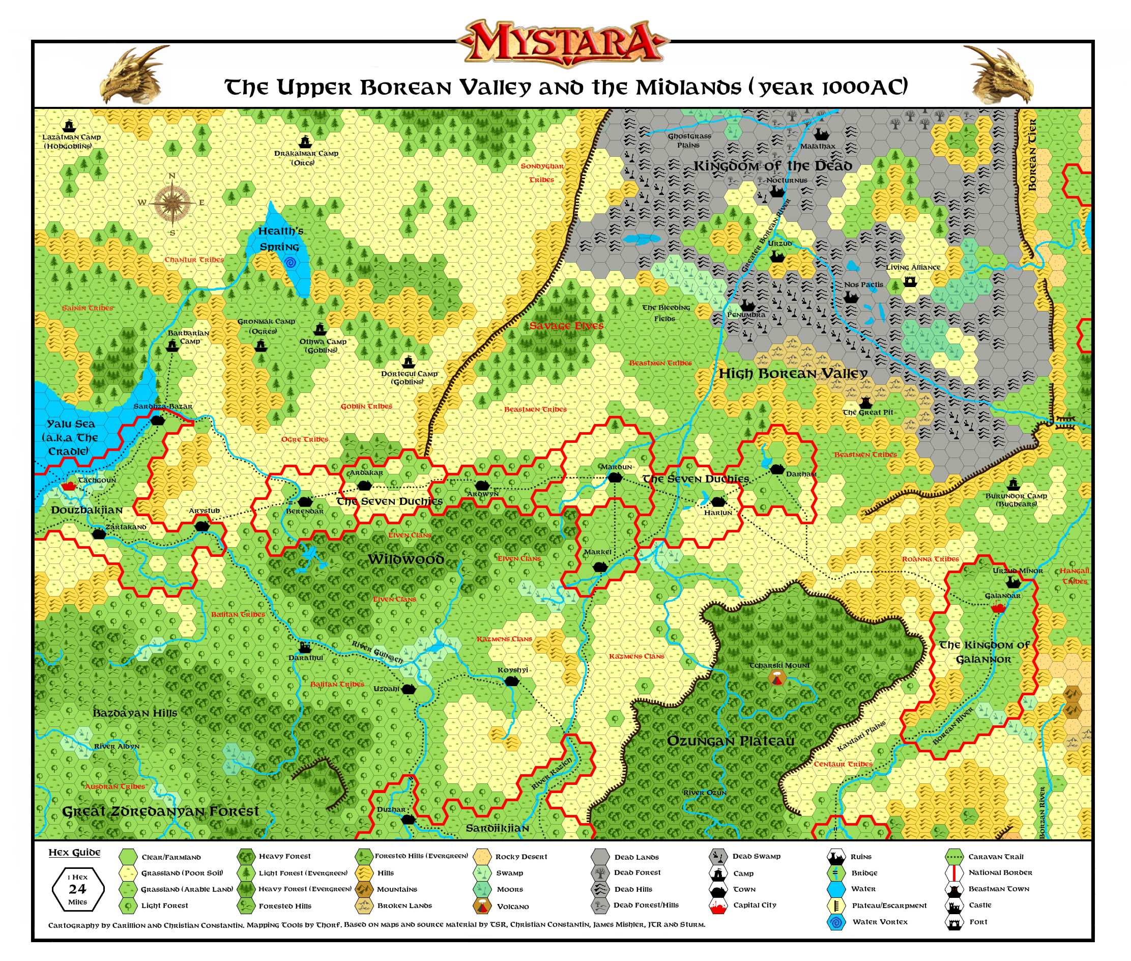
This map includes the following geographical locations, with mention of the relevant authors (and apologies in advance if any of this is wrong):
Galannor (James Mishler)
The Seven Duchies (James Mishler)
Wildwood (Canon - AC1 Shady Dragon's Inn)
Borean Valley (Canon)
Douzbakjian and Sardjikjian (Christian Constantin)
Health's Spring and the Cradle (Canon)
Ozungan Plateau (Christian Constantin)
Roanna and Ausdan tribes* (James Mishler)
Kazmen and Balitan tribes (Christian Constantin)
Urzud (Canon)
The Kingdom of the Dead (JTL)
Drakalmar Orcs (Sturm)
Savage Elves (Canon)
Gronmak Ogres and Othwa Goblins (Bruce Heard)
Kantari Plains and the Centaur Tribes (Havard)
*Please note that the other three tribes mentioned by James Mishler are situated off the map (the Shonaks are further North, the Uimach are to the South, while the Andar are off to the West. I've gone with Sturm's placement of them on his impressive Brun map.
In case anyone wants clarification on where exactly the lands on this map are situated , then the location can be surmised on this excellent map by LaZompatore.
Many thanks to all of those mentioned above whose works I have used as inspiration for this map. And a special thanks to Christian Constantin for working with me on this project, and making the end product much better than if I had just worked on it by myself.
We have tried to pay very close attention to canon material for this map, which has meant adding more forest than previous fanon maps of this region. We have also tweaked the relevant river tributaries along the Borean valley to match what little Canon material there is of this area.
I've finally got around to making a number of changes to the map in response to the comments I received previously. The updated map can be viewed here:
The changes I have made include:
1) adding several humanoid tribes that were on Sturm's map that were not showing on mine;
2) Reverting the lands around Urzud back to normal (as opposed to dead lands). It makes little sense to have the old humanoid capital in the middle of a potentially radioactive area, as this area was populated by the humanoids after the destruction of Blackmoor, and not before;
3) Reverting some other areas in the Borean Valley from dead land to normal land. Some concern was expressed exactly how much dead land there was on the map (especially as according to JTR's work, the dead lands stretch some way north from the top of my map). Having reviewed the material, I agree that the initial ideas were overdoing it a bit, so more lands are now no longer showing as dead in this area;
4) Adding the living Alliance to the map. This was shown in Sturm's map, but not on mine. I have however upgraded the settlement from a village to a fort, due to the dangerous area this settlement is situated in;
5) I've added more forest both South and East of the Health's Spring, in line with what little canon material there is available in this area. This includes the Savage Elves forest area;
6) I've Added a Water Vortex which flows from the Elemental Plane of Water into Health's Spring. This was discussed at the bottom of this thread here
7) Various formatting tweaks, to make the map more presentable.
The map should now also tie up with the one I did previously, which details the area south of this map. That map can be found here.