
Nearside, 40 miles per hex
by John CalvinMaps
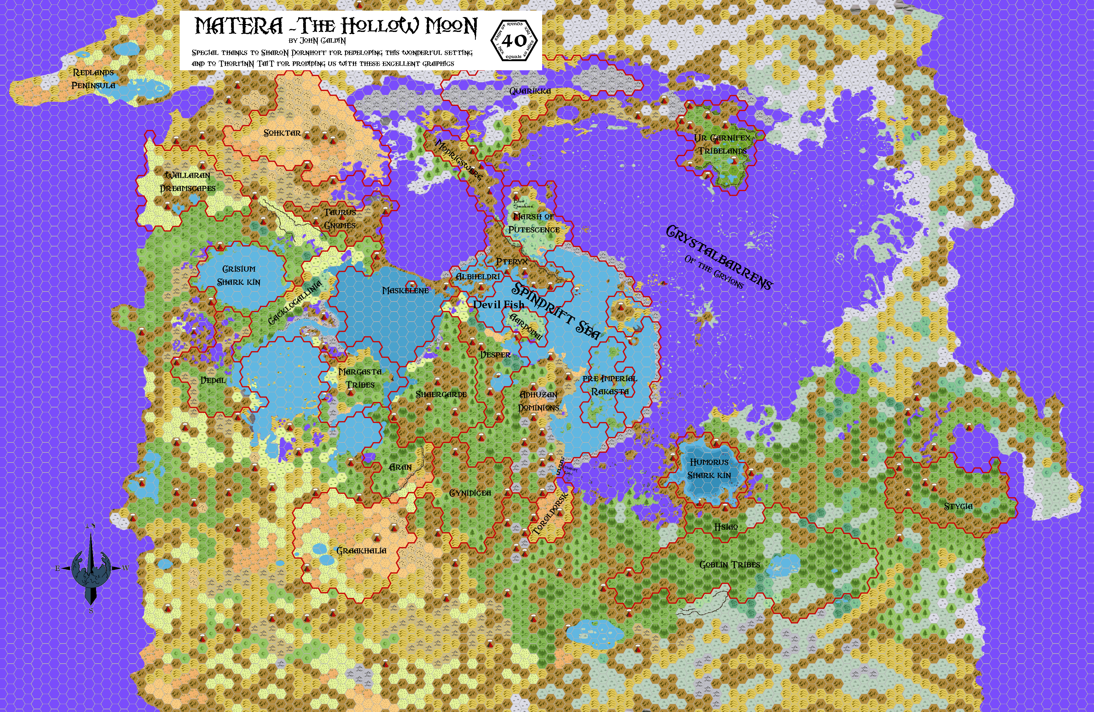
Map of the Hollow Moon, Nearside, 40 miles per hex by John Calvin, March 2009 (Work In Progress)

Comments
This map of the Hollow Moon covers the Nearside - the inside section of Matera that is always facing Mystara. The base map is a mirror image of our own moon, Luna. The darker blue/violet color represents the crystal firmament of Matera. These are the dark patches on the face of the moon (and on the inside of it as well). It is through the crystal firmament that light from the sun will shine through to illuminate the interior of the Hollow Moon in a dim blue light. Gray hexes represent areas on land that have not been mapped yet. All other hexes should be standard.
The map may change as I get a better understanding of the lunar topography as well as of what Sharon's original intentions were. In some cases Sharon has documented her vision of the map in the Hollow Moon material, and in those cases I will try to represent that vision as best as I can. Once that is done I will begin to extrapolate the rest of the map.
I am also using RL lunar names for ease of discussion (as Sharon did), but keep in mind that the maps above are a mirror image of the normal lunar landscape.
Sources: Inside Matera: The Hollow Moon by Sharon Dornhoff
Notes on Hollow Moon Size
Here are some general notes on the moon map:
I've taken my size estimates from this article by Daniel Boese: Information on the Mystaran moons, Matera and Patera
Matera
Diameter: 2160
Circumference: 6786 (roughly 170 hexes at 40 miles per hex)
Thus the map should be 170 hexes long, by 85 hexes high. I am working on a copy of the full map, however the map I've posted here is a cropping of the Nearside that shows all pertinent features at this time. The poles are not currently included, nor is the Farside (which is just crystal firmament and so will probably not receive a treatment).
Questions for Sharon:
1) There is a feature called the Archerusia Promontory that separates Tranquilitatis from Serenitatis.
BM-ST wrote
Foecunditatis is so heavily-grown with coral, that its seabed is actually much more shallow than its sister-sea's ... There are far fewer islands and crust-flats on the coral-sparse, sandy bottom of Tranquillitatis, and its ill-lit depths are a mystery to the city-dwellers. They also don't know that the northern edge of Tranquillitatis -- a high, unbroken ridge connecting the Archerusia Promontory to the opposite shoreline -- is a deliberate artificial creation of the Immortals: one that keeps the two seas from flooding the Mare Serenitatis crystalbarren. ...
There are some subsequent references about the location of the Kopru Dominarchy, one of which refers to the Straight Wall (which I assume to be the same as the Archerusia Promonotory) and another which refers to the SWPA range.
BM-E wrote:
Behind the Straight Wall, a manmade barrier against cryion depredation, the far-more-predatory kopru of the mountains tug discreetly on the strings of their grand puppet empire -- its befuddled, non-kopru inhabitants, hiding their mental subjugation behind a facade of placid civility. Only the constant vigilance of the Deslandren kouprey-ranchers to the west, and the ferocious guerrilla warfare of Shaergarde to the east, has kept this taint of imperialist mind-manipulation from spreading further.
BM-AL wrote:
In the subterranean hot springs of the Stofler-Walter-Purbach-Arzachel mountain range, giant clams and tubeworms which cluster round the spewing "black smokers" use chemoautotrophic bacteria to live on hydrogen sulphide, and these in turn provide nourishment for the kopru and a bewildering array of intermediate lifeforms... many of them extinct throughout the rest of the world, long before the Hollow Moon or even the dinosaurs ever existed. Slithery giant hagfishes, and relict trilobites unseen beyond the vents since the Cambrian, are among the least-alien of these freakish fossils come to life.
These two locations are separated by some distance and it doesn't seem likely that the Dominarchy extends through each. I'm assuming that the reference to the SWPA is correct, but I'm not sure.
2) There are some references to the western border of the Spindrift Sea:
BM-ND wrote:
... the awesome Mount Copernicus on the Midland Ocean's western shore ...
Copernicus is said here to be on the Midland Ocean's (Spindrift Sea) shore, however previous references state that 1) all of Procellarium within 25deg of 0,0 should be included in the sea (which should encompass Copernicus) and 2) a reference to the Carpathian Archipelago (which would be behind Copernicus in the sea). I'm currently drawing Copernicus as a fairly large island in the Midland Sea, but I'd like to get your input on this.
3) I'd also love to get your input on the Foecunditatis/Tranquillitatis Strait.
BM-ND wrote:
... Taruntius on the Foecunditatis/Tranquillitatis Strait is infamous for its fumaroles ... Gutenberg's lava-flows follow the same path southward, year after year, building up a long ridge that reaches much of the way to Mare Nectaris while seldom endangering any lives. The very young volcano known ruefully as Hell* popped up out of a beet field in Deslandres less than 70 years ago, has grown into a full-fledged cinder cone nearly a thousand feet tall
I actually drew a large portion of the map (mostly the crystlbarrens and seas) before going back and really reading (and understanding) your descriptions. I did this purposely, in order to see how much of my own visions matched with your own. In the case of the Straight, I figured that the narrowness of the straight, coupled with the freezing properties of the crystal beneath it, might create an ice fringed passage between the two seas. I see this as being a very dangerous place, with the ice from the crystalbarrens being thawed and cracked constantly by nearby volcanic activity. In this case the straight would be very hazardous to traverse (what with all of the icebergs floating through it). What are your thoughts.
4) Related to #3 above, there are several places (especially near the seas) where there are patches of barren crystal open on the landscape. Again, this stems from drawing the terrain before going into your descriptions in depth. What do you think about these scattered crystal patches?
5) What kind of terrain should be around the Altai Scarp? I'm not sure I'm happy with my current depiction. Should it be more rocky, or should it be more woodsy? If you could provide some input here that would be great.
References
Thanks to: Thorfinn Tait, for providing some wonderful graphics to use in all of our mapping projects, Sharon Dornhoff and Geoff Gander for developing the setting.
Also thanks to Havard, Geoff Gander, Andrew Theisen, Hervé Musseau, TraverseTravis for their support during this mapping effort.