
Known World BC 1750, 8mph
by John CalvinMaps
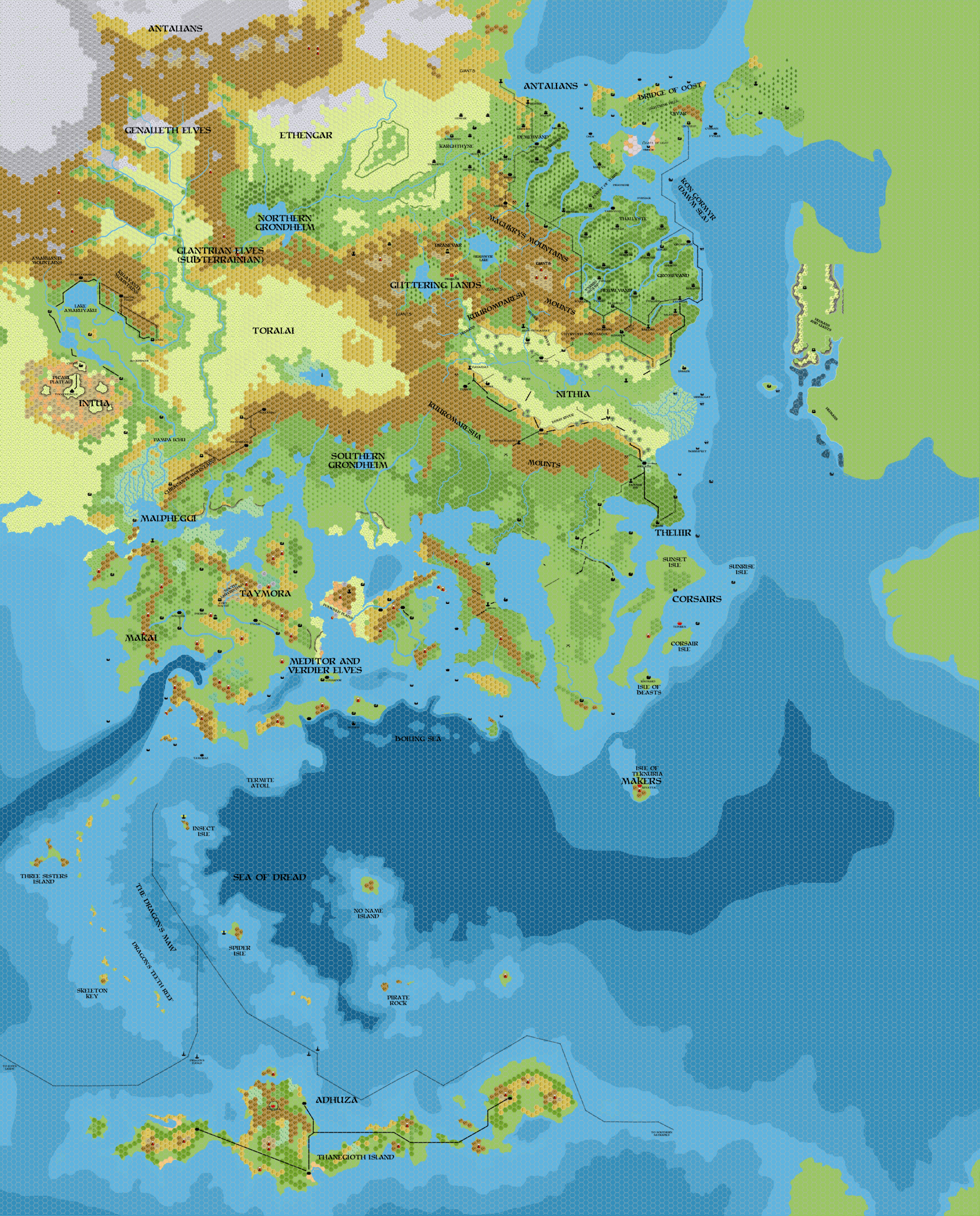
Map of the Known World, circa BC 1750, 8 miles per hex by John Calvin, September 2011 (Work In Progress)


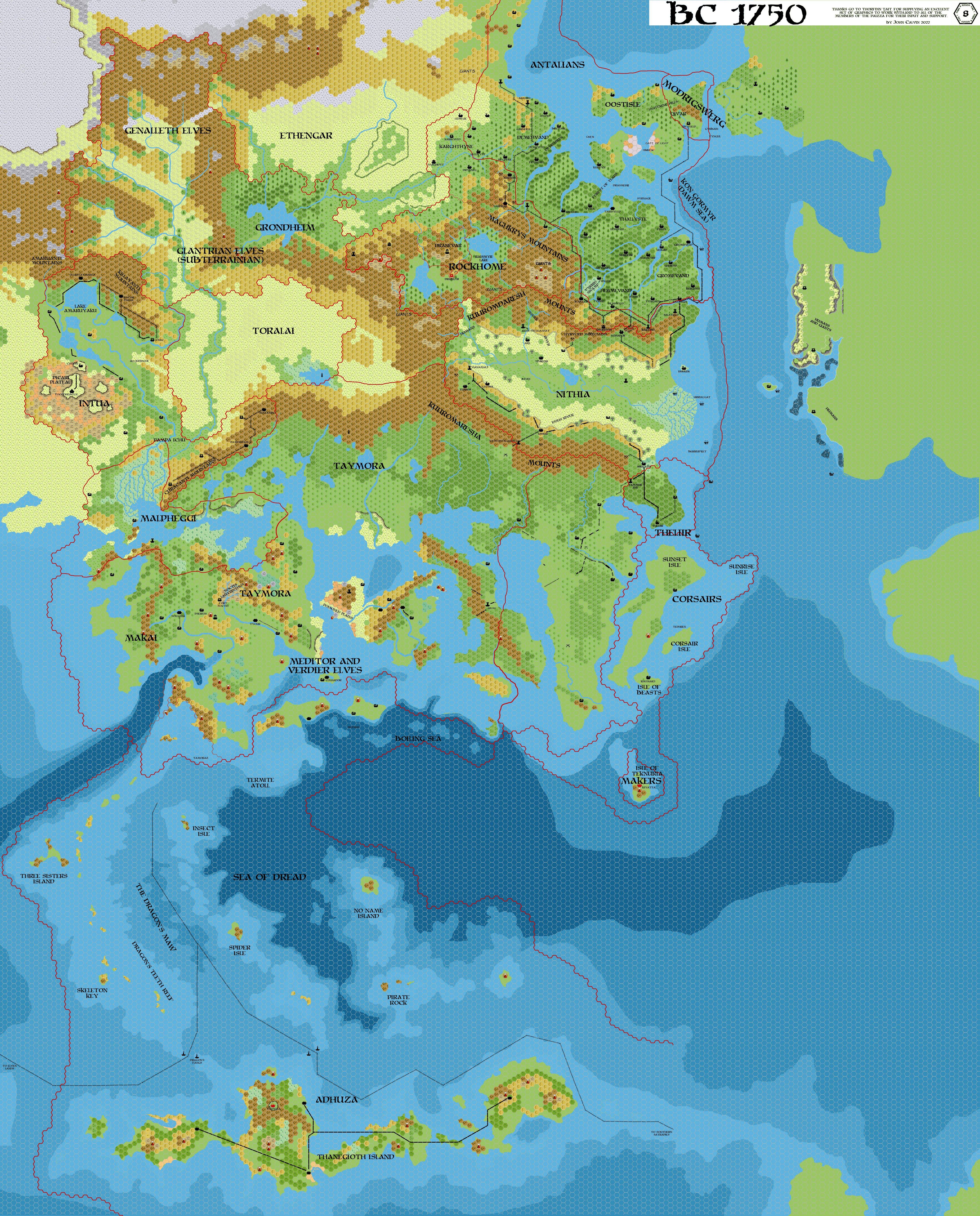
Map of the Known World with Borders, circa BC 1750, 8 miles per hex by John Calvin, September 2011 (Work In Progress)
Comments
1) This should be just after the first major geological event that sinks Taymora. These events will continue until BC 1720 until the final event gives us our modern shorelines.
2) The ruins of Isshum are still on this map, but they will finally disappear under the sea in BC 1720.
3) The Great Plateau is mostly crumbled at this point. It will be completely destroyed in BC 1720.
4) Taymora has broken up into three major islands. These will be broken down into the familiar Minrothad and Ierendi islands by BC 1720.
5) The destruction of the Great Plateau has changed the course of the "Streel" river as well as the shape of Lake "Amsorak". These changes in water flow have helped to create the Malpheggi swamp.
6) The river Nithia has changed the terrain in the Ylaruam region. Silting by the river has pushed the shorelines further out into the sea.
7) The Bridge of Oost has sunk, leaving Oostland island.
8) There is still quite a lot of tweaking to do on this map. I need to add BC 1750 cities, and especially focus on the new Taymoran terrain.
Sources:
References
- Mystara BC 2300
- GazH Project
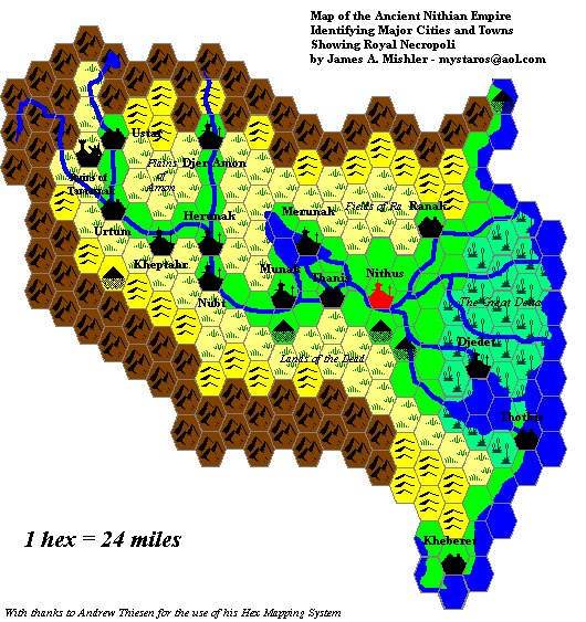
- Ancient Nithian Kingdom
- CM9: The City of Deep Swamp
- Ancient Nithia 1500BC-8 mile hexes by Robin
Thanks to: Thorfinn Tait, for providing some wonderful graphics to use in all of our mapping projects, Hugin for his work on the GazH project, James Mishler for his early work on Ancient Nithia.
Major Events
- In BC 1750 the first series of earthquakes and volcanic eruptions splits large chunks of Taymora off of the mainland.
- In BC 1750 The Great Plateau completely collapses.
- Large portions of the Bridge of Oost are inundated by the sea
- Many of the islands in the Sea of Dread, including Adhuza, shrink as the oceans rise.
- Shimmering Lands civil war in BC 1800 results in the re-creation of the dwarven race, and the establishment of the nation of Rockhome.
Map Labels
- Adhuza - Nation controlled by the kopru
- Antalians - Nethar descendants who have been living in a harsh and cold climate.
- Corsairs - Society created from freed slaves that has turned to maritime trade and piracy
- Ethengar - Warriors and expert horsemen.
- Frontierlands - A no man’s land between Taymora and (formerly Mogreth) populated by individualists and frontier explorers.
- Genalleth Elves - These elves are the forerunners of Ilsundals migration
- Glantrian Elves - These elves fled underground during the Great Rain of Fire and have only recently decided to return to the surface.
- Grondheim (Northern and Southern) - Nation of giants and fey led by the Troll Queen.
- Intua - Descendants of the Azcans who took shelter under the Great Plateau after the Great Rain of Fire.
- Makai - Nethar tribes that have specialized in sea trade and subsistence.
- Makers - Refuge of ancient Blackmoor that escaped the destructive upheavals caused by the Great Rain of Fire who have turned to fleshcrafting
- Malpheggi - Lizardfolk and other refugees from Mogreth
- Meditor and Verdier Elves - Forerunners from Ilsundal’s migration that have taken to the sea.
- Mogreth (Destroyed)
- Theliir - a remnant of the recently destroyed Mogreth empire.
- Nithia - the fledgling human nation that is destined to be the first real empire since Blackmoor.
- Rockhome - Dwarven followers of Kagyar.
- Taymora - Nation of vampire queens and undead
- Toralia - Nethar tribes that are known as buffalo riders