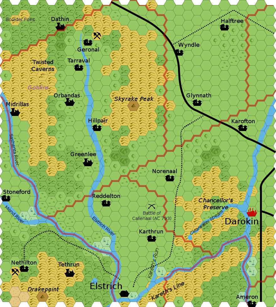
Locations:
(Anything not described below is from the Gazetteers. Anything not sourced was created for this map.)
Villages:
Ameron: See Malpheggi Swamp
Geronal: This small mining village has seen better days, since the ore veins which led to its initial prosperity petered out. However, rumors of new finds occasionally arise, but they have not been able to staunch the slow decline.
Glynnath: Glynnath is an old, small farming village. Although it lies near the Akorros/Darokin road, the inhabitants have often been suspicious enough of travelers that the village is ignored by the traders (and vice versa). (Some historians claim that the village was founded long enough ago that it was a sister-village to Elstarath (now known as Elstrich), but it has retained its original name.)
Halftree: Small sustainable lumber, recent settlement
Hillpair: Small farming village, some lumber
Karofton: Small farming village
Karthrun: See Malpheggi Swamp
Nethilton: See Malpheggi Swamp
Norenaal: See Malpheggi Swamp
Reddelton: See Malpheggi Swamp
Stoneford: See Malpheggi Swamp
Tarraval: This small farming village was the first real resettlement of Elstrich valley after the horrors of the Red Duke's reign came to an end and his power was obliterated. Fiercely independent and mindful of past events, they have chosen to avoid concentrating any power in the hands of one (or a few) and instead work through village-wide consensus.
Wyndle: This small farming village provides a convenient stopping point betweek Akorros and Darokin, and the nearby trade route with Halftree has increased its prominence as a meeting place for those interested in exporting Halftree's lumber.
Keeps and Towers:
:
Lairs and Ruins:
Dathin: Ruins dating from the time of Irum. Although the forest has mostly reclaimed this settlement, what folklore survived Irum's fall suggests that this was once a village which rebelled against the Red Duke's atrocities and was razed to serve as an example to discourage more widespread resistance.
Greenlee: See Malpheggi Swamp
Midrillas: See Sashenta Valley
Orbandas: Ruined one-time capital of Irum. (Geoff)
Skyrake Peak: This dome of rock thrusts up from the nearby hills which eroded away around it. However, having been used by several dragons at various times as a lair, what was once a rounded peak has been broken and has become jagged enough to inspire the rather dramatic name. A cave complex has been carved out, with easy access for flying creatures and a few hidden pathways for servant tribes. Although no dragon sightings have occurred since the valley resettlement has begun, it is always possible that a young, up and coming drake may choose to move in.
Tethrun: See Malpheggi Swamp
Twisted Caverns: This cave complex, which takes its name from the nature of the tunnels which twist and turn for miles, had once been used as a possible retreat for various human inhabitants of the area. However, they have been unused for the last couple of centuries and may well have attracted a new set of denizens.
Other Areas of Interest:
Boulder Point: See Akorros
Inhabitants:
The remnants of a kobold tribe or two who have served past draconic masters of Skyrake Peak may still dwell in the nearby hills. Similarly, goblin tribes live in the hills around the Twisted Caverns. Humanoids here tend to keep a lower profile, as humans are moving back in and can bring a great deal of force to bear. (Once the area is fully civilized again, it will be unlikely that monsters will continue to be able to survive in the hills.)
Adventure Seeds:
Closing notes:
This area is loaded with history, and especially dominated by the former presence of the Red Duke of Irum.
Ruins are all along the Elstrich river, from the destruction. Some humanoids had moved into the hills as the area was depopulated, and are probably being slowly wiped out or forced to move.
Names: -naal (modernization: -nal) shows up sometimes in this general region in place of "-ton"/"-ville", etc. Sashenta-ish names tend to be adj.+noun (Stone-ford, Green-lee, Hill-pair, Half-tree). Much more common with newer towns.