
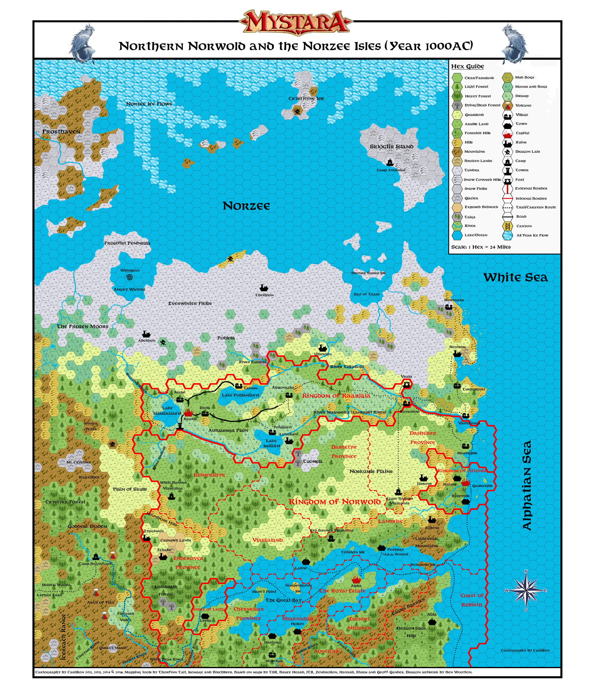
Northern Norwold, 24 Miles per Hex
by Matthew FleetThe map has finally been completed and can be found here.
Naturally, my thanks goes to all those who have worked on the various mapping tools that I used, as well as to all those whose maps I have used in part to compile this new updated map of the region. Unfortunately, the list of names is too long to give here (I have used as a reference point about 15 maps!).
Some points to note regarding the map are as follows:
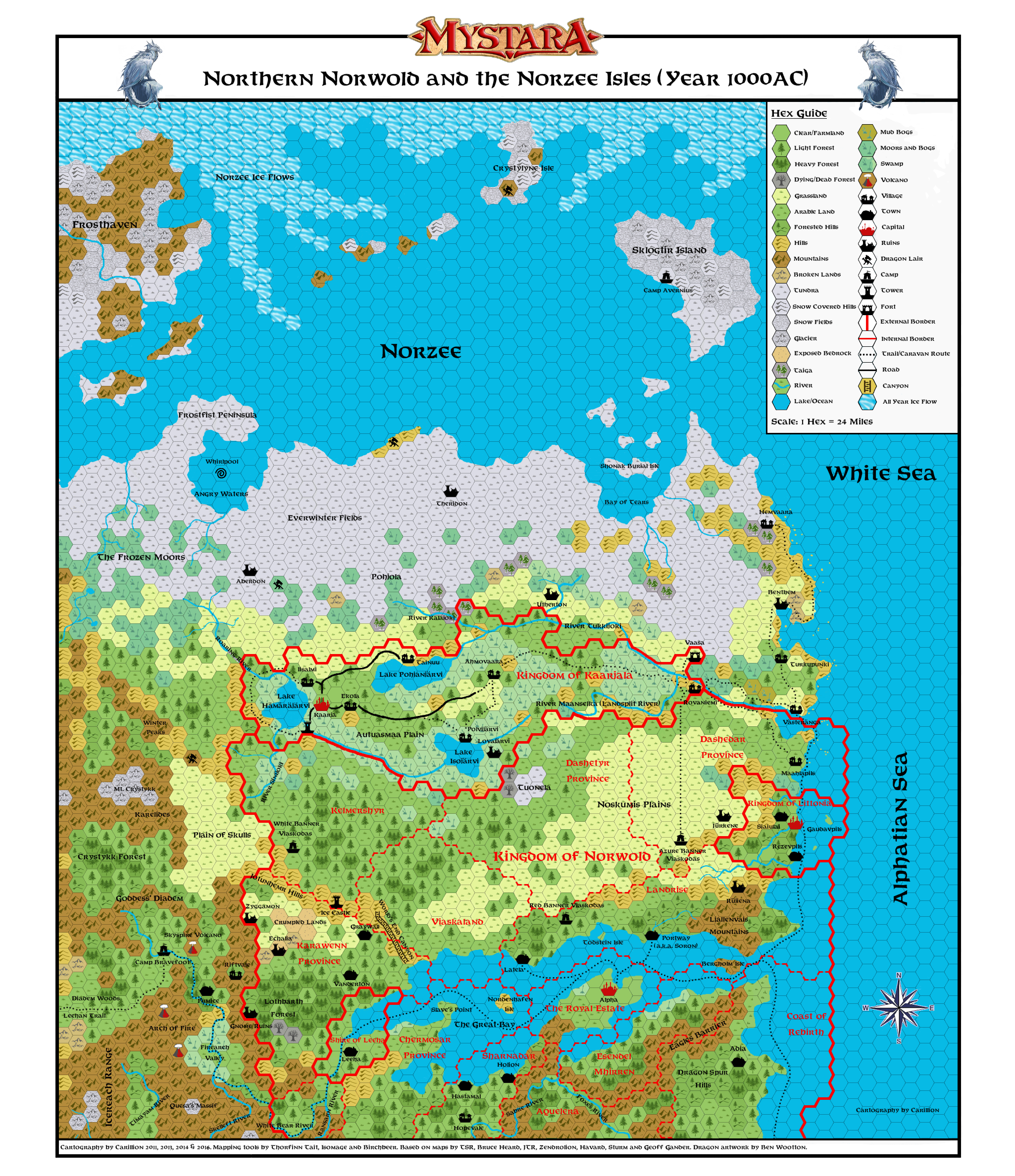
1) Karawenn has been added into Norwold, just North of the Shire of Leeha.
2) I have added a suggested route for the Leehan trail which leads to Ghyr.
3) The trade routes going south from Kaarjala and North from Itamaa have been completed with a suggested final destination (which was not originally shown on the Fan Gazeteers of these regions)
4) I have included the dominions of any character who was in CMI (Test of the Warlords) onto the map, if their dominion appeared anywhere in this region in previous fan maps. I have also added the County of Lintaine, which is covered in detail here.
5) On the vaults of Pandius, the three Viasksoda tribes are described. I have set up a camp for each of these, using the locations described for where these tribes are usually found. The camp represents the location of their respective religious grounds where they gather during the summer solstice. During this period, 10,000-15,000 barbarians can be found at these locations. At other times of the year, this camp will usually number about 900.
6) There have been a number of differences in previous maps of this region, especially regarding which areas are forested North of the Great Bay, and where the mountains actually lay on the West of the map. I have tried to accommodate as much as possible, but have had to make some decisions about which maps take precedent over others. Hopefully, no one will take offence if parts of their maps have not been used here!
7) I have fleshed out parts of the map North of Kaarjala, as no maps I have seen went into much detail of this region. The new locations I have added will be detailed soon in issue 2 of Threshold.
8) I have included some villages (which do not normally appear on 24 mile hex maps) to ensure that some trade routes and dominion borders make more sense (ie to avoid trade routes ending abruptly at no settlement etc). However, it should be noted that not all villages in this region are shown on the map.
9) The hex tiles should generally be self explanatory. One which may need clarification however is the difference between the yellow and green grassland hexes. The yellow one represents grassland which is only average or less with regards to farming potential, while the green one represents grassland which would make excellent arable land. Clear hexes represent land which has already been converted into farmland (these usually are only present near large settlements), and these lands are generally civilized and safe to move around in.
10) One of the canon maps shows the Northern border of Norwold cutting through Kaarjala. Naturally, this map was designed before Kaarjala was placed in Norwold, so I have tweaked the borders in this region to exclude Kaarjala from the dominion of Norwold itself. This is because it is very unlikely that half of Kaarjala would be part of the dominion of Norwold and half would be outside of it! The Fan Gazetteer of this region also states that Kaarjala is not under King Ericall at the time this map represents.
Naturally, if anybody can spot something obvious that I have not included on the map, then please let me know and I will try to add it in.
The new map (above) supersedes the map I did for my article that was published in Threshold issue 2, and should also be compatible with Thorf's recent mapping project (which is well worth a look if you haven't already done so!).
About 90% of my latest map agrees with Zendrolion's maps that were published in Threshold issue 7 (I've amalgamated most of the details of the two separate maps he did of this region). The main area where there are still noticeable differences involves Leeha and the surrounding regions, as JTR also published a map with a different take of the area at about the same time. As these maps were published in the same edition of Threshold, I'm assuming that neither of them knew what the other was publishing, and so couldn't tie them up accordingly). I've now tried to rectify this and have tied them up as best as I could. Threshold issue 7 can be found via the following link for those that are interested in viewing Zendrolion's and JTR's maps.
Whilst I was working on the previous version of my map, I had missed a sketch of the Great Bay that was hidden away in one of the Poor Wizard's Almanacs. This sketch shows some interesting details such as trade shipping routes and the northern coastline of the Great Bay. I've therefore made some changes to my latest map to reflect this. Bruce Heard also published an excellent article back in 2012 about Brun's climate which has influenced my latest map. It also appears that Zendolion used these sources as well. Bruce's article can be found here.
The only disagreement I have with Bruce's climate map is that in my opinion, the Eastern coast of Norwold north that lies north of the Landsplit River would not be tundra until further north, due to the maritime winds which would make the coast slightly warmer. Here is a map of the real world's taiga (pine forest) area.
As you can see from this illustration (the part which represents Western Canada, which is the real world equivalent of Norwold), taiga can grow further North on the eastern coast than the lands directly to the West, where the climate drops in temperature. This explains why I placed taiga on the coast near the village of Hemvaara, but not further inland. Incidentally, the Wikipedia map suggests that we could even put taiga on the Norzee coast at the southern end of the Bay of Tears (but not directly south of it), although I'm not proposing I actually do this.
It should also be noted that in Fan Gazetteer for Kaarjala (F10), it details an artifact called the Great Sampo, which creates warm air for Kaarjala itself. This would push back the arctic climate (which is denoted by blue in Bruce's article linked above) for this area as well.
The only other issue that needs a mention is Karawenn. This location is canon, as it is the subject of three novels by Douglas Niles. However this area was never placed anywhere specific, and so its location is up for debate. More can be read about Karawenn here.
The most popular placement for Karawenn is just North of the Great Bay, although it doesn't appear on either JTR's map or those completed by Zendrolion. I've however drawn an alternate version of my latest map which changes the name of the Norwold province of Enderover to that of Karawenn, as well as adding some towns that appear in the relevant novels. I've also included the World's End Canyon which also appears in the novels. This map should be useful for those who wish Karawenn to be placed in Norwold, and can be viewed here.