
I really have much more on western Davania: unfinished maps of Izonda and Pelatan 24 mph, descriptions of nations and places and a draft global map. Here is the mail I wrote to Thibault and others of the Davania group 5 years ago (argh . IIRC Thibault wanted to draw a political map of the area but I don't think he did it... Anyway here is the mail:
(And the map here)
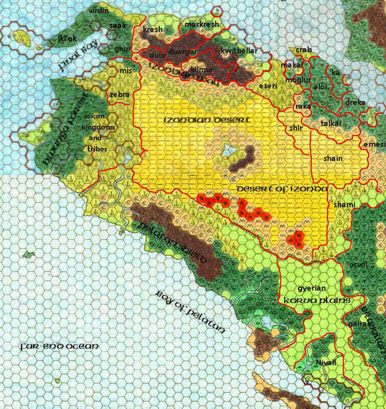
Northwestern Davania
by Francesco DefferrariHello,
sorry If I write to you quite later than I originally thought, but real life has the bad habit to mess with my hobbies Anyway, let's begin with geographical informations that you could find useful to draw a 24 miles map, beginning from the north west and clockwise from the final bay to Arica (If anyone has more suggestions, please write them, and obviously you are free to take these writings as simple ideas and not as mandatory indications)
Jkl'ok 150.000 inhabitants, Orcs and Crabmen with a primitive society that recently discovered commerce and is eager to find new commercial partners: I imagined this nation as a federation of tribes, with three main people: crabmen in the north east, hills orcs in the east and jungle orcs in the west. They should have only villages and not cities, the terrain should be almost all jungle and forested hills, with some great beaches in the north west. (Crabmen villages should have names like Klok'nol, Xok'kil, Hlik'od, hills orcs villages names like Jok'vol, Kol'mor, Tok'nar, Kon'tor and jungle orcs names something like Kanok, Dakor, Kewok). A think they should have colonies of Gombar and Suma'a as neighbors in the west (the islands on the tip of the final bay peninsula) and in the east (the three cities in the final bay gulf). This nation should be 300 miles long (from the tip of the peninsula to the river just before the name Virdin in my map). Anyway if Geoff thought that the cities and the west islands should not be of Gombar and Suma'a there is no problem from me. Probably on the tip of the Final Bay peninsula there is a big city, an important trade city for this area (with a Gombarian or Sumag name, something like Jakan or Amara or Aratuo, Muda, Tambar, Jana'a and so on)
Virdin 150.000 inhabitants, (north of final bay) a strange culture born mixing orcs, ogres and faerie folk. Kind hearted and magic using humanoids: a nation more of less 200 miles long, with a capital on the north shore (proposed name Maderin), most jungles and some beaches and prairies on the north east, and some other cities and villages (possible names Edarin, Intari, Nive, Vanker, Tead, Mover or similar). They should have a fort or two along the border with Saak, even if the two nations nowadays should be at peace.
Saak 200.000 Orcs and ogres living side by side with throglodites. A nation that desperately try to reach civilisation with many difficulties. A large nation with beaches and prairies in the north, jungles in the south and some forested hills in the south east. They should have only villages (proposed names Viseek, Kaasik, Mookar, Sadak, Liinok), with just a town far from the sea but near to the city on the west coast (the city with the red border, probably inhabited by colonists from Gombar of Sumag, with whom they trade).
Ghur 150.000 Orcs and ogres with a military tradition based on honor in battle. Still bad humanoids, but with a lot of nobility :- ) An unified nation, all jungle, with the river as the north border and the lake as the southern border, I'd said no cities but villages and towns (proposed names Ghur Mag, Ghur Ser, Ghur Wod, Ghur Kadan and so on). Probably fortifications on the west border with Izonda and on the north western border with Kresh.
Mis 100.000 Minotaurs nomad that from time to time attack their neighbours: You know the entry of this place yet. I would add that they probably shouldn't have permanent villages but only a temple or "sacred place" on the southern shore of the lake in the north (the name of the temple should be Ela Mis). Their territory shoul be jungles in the north east and prairies everywhere else (maybe with desert patches)
Zebra 150.0000 Zebrataurs. Nomads with a strong druidic sense: They live just to the south of Mis and they are nomads too, so no permanent villages but maybe a "capital" or temple in the centre of their nation (maybe named Akize). The territory should be all prairies, with some little river (less dry than Mis, I mean).
Kresh 250.000 goblins. (Jeff Daly) Goblin tribe, with a deep hatred for everyone and Kwithellar elves in particular: I imagine it as a huge nation inhabited by a goblin horde with many different tribes (so villages with names like Uresh, Sarish, Keneurosh, Shovur, Vushar), and maybe a sort of underground capital in the mountains near to the end of the river (more of a meeting point/temple than a real city, named Vorkresh). Maybe one volcano on the mountains.
Markresh 200.000 inhabitants. (Jeff Daly) Ex-slaves of the elves, goblins with human intelligence and dwarven loyalty. Friends of the dwarves and enemies of the elves: This should be a "civilized" and militarized nations, with a capital on the north shore (Markreshassar) near the mouth of the river, many cities and forts and walls along the border with Kresh and Kwithellar, no forts and walls along the southern border with Duargor. I would give slightly elven names to the cities in the east, something like Mirishel, Telinivash, Shyawilla, slightly dwarven names to the cities in the south east (Arshaor, Tuor, Mondar) and more goblin like names in the west and north (Morush, Kumish, Xoshoras)
Duargor 150.000 inhabitants. (Jeff Daly) The last Kogolor dwarves of outer Mystara, enemies of elves, kresh and kilmur but allied with duur and markresh: The nation is all mountains, probably with some lakes and volcanoes. They have cities (names like Murdan, Eftdan, Bardan, Syrost) and a capital (Danduarg), and surely forts and towers along the eastern border with Kwithellar. (Fortress names: Khuzgar (safe dwarf, near Duur), Eluzkor (elfs'death, in the east), Grozkor (goblins'death, in the west), Farblyzkor (evil blood's death, near Kilmur) Meyadan (friends'rock, near Markresh)
Duur 100.000 inhabitants, mixed dwarves-orcs, a warlike tribe with good relations with duargor and bad with anybody else: Their territory is made up of mountains in the west and hills in the east, they have a capital (Vamuur) in the mountains and strongholds along their southerns, northerns and eastern border, being at war with everyone but Duargor, and able to resist only because they inhabit steep mountains and hills, easy to defend. (Some strongholds names: Deenor, Vokaar, Took, Kwaador)
Kilmur 250.000 inhabitants. A nation of mixed blood orcs and elves, who desperately tries to imitate the Kwithellar decadence and civilization and is used by the Kwithellar as a buffer with izonda: I think they should have their capital more or less in the centre (named Kilmurlot), where the eastern hills meet the mountains. They should have forts or towers along the borders with Izonda and cities along the border with Kwithellar to trade with their northern neighbours. (Names for forts and cities: Kinisheras, Shuost, Kwekitot, Gronande, Kaloron, Suktun).
Kwithellar 400.000 inhabitants. (Jeff Daly) a decadent realm of elves with an evolute civilisation devoted to pleasures, and with many enemies around, fighted usually with humanoids, humans and dwarves slaves: A bit of Kwithellar you can find in my map of Eseri lands, anyway they should have some cities, the capital on the north western coast (number two on Geoff's original map) strongholds and forts in the mountains. (I have given the prefix Tir or Cer to forts and stronghold, and the prefix Tiar to any big city. The capital could be named Tiar Thellar).
For Eseri, Schweidnitz, Mogluur and Tlik'kil (crabmen lands) you have my 8 miles maps and my entries.
A bit of Alol (200.000 inhabitants) is to the right of my Mogluur map, the rest of the country should be similar, jungle with some hills and rivers, the capital in the centre a bit on the south east, maybe on the shore of a not too big lake. They have some forts along the western border (Mogluur) and eastern border (Ka). (Names for the eastern and southern part of the nation: Kamol, Baadol, Talool, Rakevool)
Ka 150.000. An ancient and sophisticated nation of Troglodytes ex-slaves of the Carnifex Empire that rebuilded Carnifex towns and were later joined by Oltecs and orcs. Nowadays the troglodytes are the nobility of the realm and the half orcs are peasant and laborers (not slaves anyway): Probably their capital is on the north coast (named Katrog), but not exactly on the sea. Most of the country should be jungle, but with farms and plain around the major cities. They should have a fortress along the southern border with Dreka and another two along the western border with Alol. (Names: Askar, Moak, Teke, Kok, Saik, Dagor).
Dreka 150.000. A nation of rakasta and oltecs escaped from the blackmoorian colonies long time before the great rain of fire. Now in a bitter fight with the Bellayne colony that wish to assimilate them: Mostly jungle, they should have a capital in the centre (Kan Dreka), some cities (Ashsta, Kraad, Mishsti, Selsha) and probably burned towns and forts along their south eastern border.
Talkai 300.000. A theocracy of Ixion founded in 2800 bc from refugees of New Blackmoor joined in 600 bc by Varellyan dissidents. Many Sollux among them. From ancient times they fight Sis'thik to the south: jungles in the north with villages, capital (Soltai) and cities (Kuxta, Lumka, Liata, Suhita) in the central hills, an important temple (Xiontai) in the east and a bit of desert in the south. Thay should have forts and fortresses along the borders with Shain and Shir.
Emesi 300.000 Nomads tribes of oltecs, neathar and orcs descent: many fighting tribes, many villages, jungles and hills, the north wet and the south dry, no unified power nor capital city. I thought that they should have a sort of common language, in which Eme means tribe, people, so their villages should have names like Eme Kapi (oltecs) Eme Suath (neathar) Eme Vor (orcs) and so on.
Shain 500.000 The self styled "empire" of the Sis'thik, several times on the verge of being destroyed by izonda: A hot and mostly rock desert with just some oasis and hills. They should have a great wall with towers and forts along the eastern border with Izonda, and some forts along the border with Shir too. Capital Sha'siss, in a central oasis. Cities: Sel'thikass, Thishik, Shainas, Ain'sik, Sisishalish).
Shir 300.000 An ancient nation in dire straits because surronded by enemies. Lizard men are the nobility, Sis'thik the military and troglodytes the laborers: desert with some oasis in the north, rocky in the north, sandy in the south, see the north in my map of Eseri. They should have some forts along every border. Capital: Shirsa. Other cities: Gorshis, Listra, Shimstish, Selass)
Shami 500.000 inhabitants. An empire of Orcs, ogres, goblins and lizard men. Lizard men are wizards, ogres clerics, orcs warriors and goblins bards. And songs have an important role in their culture: mostly plains and prairies, their capital should be in the middle of the north (Lishame) and two big cities should lay in the centre (Goorsham) and in the south of the nation (Gremi). The strongholds of the warriors mostly along the western border with Izonda (the central fort is named Zoora), the wizards' towers mostly in the north, temples in the south. Somewhere in the north should be the bards' city, Sablin)
Orvol 400.000 inhabitants, i thinked to jungle orcs with some varellyan blood, with a bit of varellyan civilization and many orcs customs: this should be a great nation, but it should comprise only the jungle hexes to the east of Shami and Korva plains, with the capital in the centre (Lliravoll) and 8 provincial cities (each dominated by a warrior society, and so named Farill Vol, Tean Vol, Sha Vol, Jas Vol, Keless Vol, Uar Vol, Kauss Vol and Ioss Vol)
Gairak 350.000. Probably humanoids: south of Orvol, jungle and rivers, six tribes of humanoids, mixed bloods orcs ogres and bugbears, each with a central village (names: Ai-saak, Oki-ae, Sku-mis, Has-yu, Buk-ta, Ta-wej).
Gyerian (Korva plains) 600.000 inhabitants Land of nomadic gyerian, and maybe some modified nomadic lizard men, and varellyan nomads that abandoned civilization: I'd say this land is made of just plains with some rivers and prairies, and maybe some little woods. The inhabitants should be gyerians, humans, humanoids and lizard men, in many different clans and tribes, not unified, with only villages and no big towns or cities. Place where you like the eleven most important villages: Yann, Lein, Koy, Geu, Yiel, Jai (gyerians) Shisha (lizard men) Korall, Vanis (humans) Koor, Vaako, Giiroo (humanoids)
Nivall 700.000 inhabitants. (from Geoff Gander) the Varellyan colony: This nation should have its capital (maybe named Valisia) on the north western coast (there was a border with two hexes in Geoff original map that could be the capital territory, like Washington DC in the USA, maybe) and two more big cities on the coast (the white circles on Geoff's map) and some other towns around the country (proposed names: Nasyll, Varakan, Korasa, Taishvyl, Semera, Paitya). I'd put some forts on the eastern and northern border. Maybe Geoff originally thought that Nivall should have been only the southern red border in his map, but I think that this nation should be a little bigger because there is a lot of space, I think we don't have other nations to put there, I'd would like to give space to the Varellyan culture developed by Geoff and anyway it seems to me that the two rivers (east and west) should be the "natural" border of Nivall with the Korva plains.
Pelatan: 2.000.000 inhabitants. As I wrote I planned for Pelatan 21 provinces, because the nation should be a federation of different cultures, unified by a strong and good mathriarcal empress.
Let's start from the north: the area between the northwestern border and the river 150 miles from it (the river Aupel) It's called Pelarica, 150.000, it's inhabited by Tangor people and has three important cities: Amudo, Sama and Tizar. There should be a city named Coroaci too, near the border with Arica. The area between the Aupel and the northeastern border with Izonda is the province Kedu, 50.000, inhabited by Enduks and some "humans" pelatans (the average pelatan is a sort of strong half elf with dark skin). The province ends before the Pelatan hills in the south and has only one important city, Enakia. The northwestern area on the coast between the northern peninsula and the mouth of the Aupel is Pe'kal, 100.000, the province inhabited by crabmen and pelatans. It has three important cities, one near the peninsula, Pekkil, one at the mouth of the Aupel, Lataki, and another 150 miles up the west bank of the Aupel, Shika. An area 250-300 miles long with hills and prairies between the northeastern Pelatan shield and the border with Izonda it's the Zatau province, 50.000, inhabited by zebrataurs. They have a stronghold on the hills named Tapoza. Immediatly to the east there is a little province (the desert hex and the three prairies hexes to its left) inhabited by minotaurs and named Pemina, 50.000, with one important city named Mina. The Pelatan shields has six provinces, named from north to south: Aure, 50.000, 4 hexes 140x140 miles (good dragons and pelatans, capital Sivare), Rasi, 50.000, 4 hexes (neutral and peaceful "evil" dragons and pelatans, capital Blasar) Atape, 100.000, 6 or 7 hexes (pegataurs, capital Atera) Behus, 50.000 2 or 3 hexes (peaceful beholders and pelatans, capital Madehi), Hedu, 50.000, 5 or 6 hexes (shynxes, lamassu and shedu, capital Shadusinx) Xiaso, 50.000 the southern end of the Pelatan shield (sollux, capital Ision). The great area of hills and prairies between the Pelatan shield and the border, limited in the north by Zatau and Pemina and in the south by the jungle and the plains is Eshala, 250.000 inhabitants, the warriors province, who has a capital named Sundal and at least five other important cities named Dana, Tanag, Ara, Eles and Saidu. Along the border with Izonda there are forts and walls. In the great plains and prairies of southeastern Pelatan between the borders and the southern jungle there are two big provinces: Pel'Siss 100.000 inhabitants, in the west, inhabited by Sis'thik and with capital Sisduk and two important cities, Jikshi and Shasial, and Pelgya 50.000 inhabitants, in the east, inhabited by gyerians, with capital Iyae. The jungle between the sea and the Pelatan shield is the half elven province of Elatia, 150.000 inhabitants, the capital Elan on the sea, surrounded by the two plain hexes, and two other important cities in the north jungle, Nadir and Falir. The central jungle from the Pelatan shield to the three forked river Atale in the south is the Atale province, 300.000 inhabitants with the capital of Pelatan and of the province, Iemara, just north of the mouth of the Atale river in the plain hex. Other important cities are Iasia and Niva. East of the three forks of the Atale there is the province of Rane, 50.000, inhabited by aranea, capital Otikus. South of the river Atale and north of the lake Atass there is Fylle, 50.000, the province of the fair folk, with capital Alyse. The southeastern jungle is the province of Kara, 100.000, inhabited by half-orcs, capital Oramor and three other important cities: Ekta, Miod and Jase. The last two provinces are Lysisa, 50.000 inhabitants in the swamp around lake Atass, inhabited by lizard men and with the great capital of Ysi, and Dylass, 100.000 inhabitants, the rocky peninsula in the south west, inhabited by troglodytes and others, with the big port town of Dymann on the north shore of the peninsula and the high city of Tagars in the middle of the mountains.
Izonda: 1.350.000 inhabitants. From the north, Izonda has five provinces, but every province often comprises many cultures. Edizaro, the northern province comprises all the hills and the prairies south of the Izondian wall. 100.000 Conscricted humanoids, mostly orcs and half-orcs, inhabit the hills, and 50.000 dark zebrataurs inhabit the prairies. Ghadar, the fort and trade town in the north west tip of Izonda (red spot on my map, next to Ghur and Mis) is the official capital of the province, with 50.000 inhabitants. Like every province of Izonda, Djaza has ten strongholds of the fifty noble families, with a population of 10.000 people each, surrounded by farms, pastures and mines. The families' strongholds are always named with the noble prefix N', so N'doma, N'vara, N'zulo and so on. The dominant faith in Djaza was the church of Thanatos, but since it has been outlawed has been overcome by the church of Vanya. Amuro is the central province with the capital N'djazo, 200.000 inhabitants, on the southern shore of the Amuro lake. Amuro comprises the prairies, hills, rocky desert and mountains around the lake, it's dominated by the church of Korotiku and it has ten family strongholds too. Djaza, the western province of Izonda, comprises all the western desert from the prairies in the north to the badlands in the south. El Djazair, the capital of the province, is a stronghold of 50.000 inhabitants near to the border with Arica. The ten families' strongholds of this provinces are spread among the oasis of the desert, and the people here have more human blood than orc kin blood. In the north west, near to the border with zebrataurs' lands, there is a dragon territories inhabited by hundreds of dragons allied with the dictatorship, with at least 50.000 lizard men and sis'thik servants. The capital of the dragon territory is named N'kodar. Tribes of conscricted Sis'thik live in the south western half of the province. The western province is traditionally dedicated to Hel. Shoda, the eastern province, comprise the east desert from the border with Eseri to a line passing just under the "desert of izonda" tag of my border map. The capital is named A'shamor and has 50.000 inhabitants. The north east of Izonda, the area near to the eseri border, is inhabited by 100.000 people mostly of oltec and neathar descent, dominated sternly by three powerful family strongholds. The province is traditionally dedicated to the church of Jammudaru. The southern province of Izonda is named Anada and its capital, Sodar, has 50.000 inhabitants and is located in the middle of the province. 100.000 Lizard men, troglodytes and sis'thik roam the province, 50.000 gyerians and black griffons live in the southern hills and a city of Sollux allied with Izonda, Sulan, with 50.000 inhabitants, is located in the volcanis area of the south. The province is traditionally dominated by the church of Valerias and Ixion.
Arica: 750.000 inhabitants. The red borders on the original map of Geoff could be the principal cultures/coalitions of Arica: Kavu and Thsakai, the two cities in the north coast form the coalition of Kisanga, a commercial and naval power allied with the zebrataurs and enemy of Izonda. Bwondo, the single city on the west coast. Lemei, Andu, Kikwi and Oketi, the four cities on the west that form the kingdom of Asai. The three city-states along the rivers could be named Mbui, Shika and Hebu.
That's all for now, I think. Now you should have some things to put on the map, but anyway when you've done it please send it to me, so I'll be able to help more providing more names and places!