
Free Province of Nyra
by Robin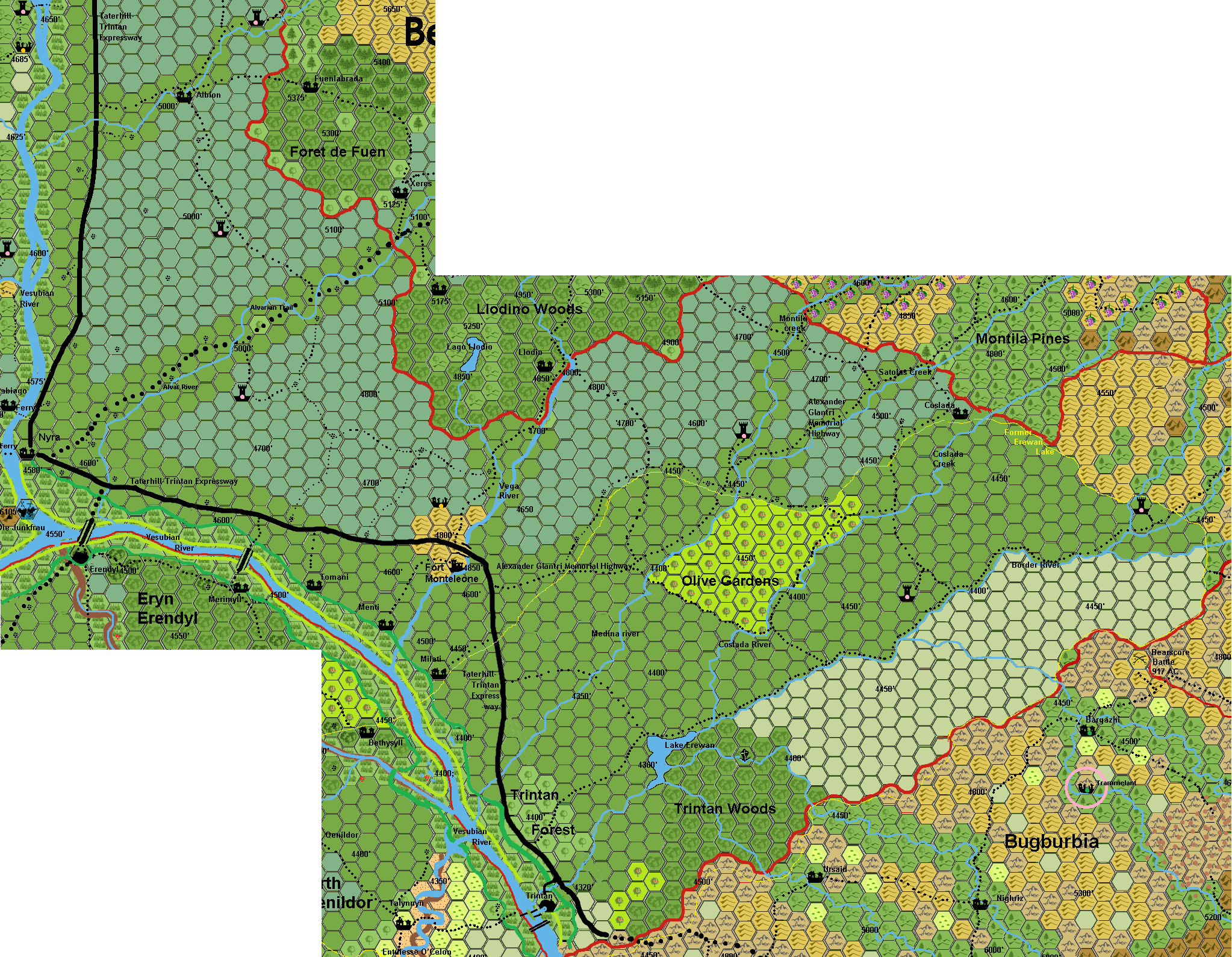
Nyra, Free Province of Glantri..also called the Vesubian valley
Towns/Large Villages:(population values given for AC 1000 and for AC 1014)
Nyra: 4580’altitude (2500/3300) Administrative centre of the Free Province. Nyra is the administrative centre of the Free Province. Nyra is the administrative centre of the Free Province and is a collection point for all the produce and goods of the region for shipment north to the Capital and beyond. The town was protected during Thar's invasion and his drive north to the Capital in 1007 by the Vesubian River. Thar ravaged the hills to the west, and the west bank of the Vesubian River on his way to the Capital.
Trintan: 4320’ altitude (1500/1700) Trintan is a commercial village whose lifeblood is trade and commerce with Darokin. Trintan is a walled town on the Vesubian River on what used to be the border with the Broken Lands. With the enfeoffment of Kol and annexing of the Broken Lands in AC 1011 the town finally could relax from it's permanent state of military preparedness. Trintan was attacked early during Thar's invasion and the two reserve divisions caught within the town held off the orc attackers and were resupplied by wizards of the Belcadiz under the supervision of Princess Carnelia, under relieved by additional divisions from Fort Monteleone. Trintan is a major commercial centre and still, even though the Western Broken Lands have come under control of Glantri and are safer for caravan traffic, is still known for being a centre for hiring mercenary and caravan guards.
City map Trintan
Selected Villages:
Coslada: 4455’altitude.(345/312) Coslada is approximately 32 miles due east of Fort Monteleone just south of the border with the Principality of Belcadiz and Montilla Pines. Coslada is a major agricultural centre for the eastern part of the Free Province.
Albion: 5000’altitude (500/400) This Fen farming village located next to the border with the Principality of Belcadiz roughly halfway between Glantri City and Nyra.
Milati; 4445 ’altitude (75/75),Reed/Thatching/Fisher village
Menti;4510’ altitude (65/70), Reed/Thatching/Fisher village
Tomani; 4520’ altitude(65/65), Reed/Thatching/Fisher village
Fort Monteleone is the primary fortress.
Water
Alvar River; begin Alvar creek/Fuentas creek to Vesubian River along Alvarian Trail.
Albion Creek; Begin Hills North-west Belcadiz to Vesubian River
Vega River; Begin Vega Creek Llodin to Vesubian River
Montila creek; Begin Colossus mountains to Satolas Creek.
Medina River; Begin Satolas Creek/Montila creek merging to Vesubian River (north of Trintan Forest)
Satolas Creek: Begin Colossus mountains in Satolas along Alexandrian Highway to Montilla River
Coslada creek; Begin south Satolas to Lake Erewan
Erewan River; Begin Lake Erewan into Vesubian River
Border River; Begin Colossal Collapse, along The Broken Trail, to Lake Erewan
Lake Erewan; 4360’altitude. NW of Trintan Woods. Fed by Border river and Coslada River. Emptying in Erewan River.
Vesubian River; The Vesubian River is navigable to river traffic from Glantri City to Trintan and sees heavy ship and boat traffic, especially in the winter months, moving trade and goods to and from Glantri City from the warehouses of Trintan.
The area of the Vesubian Valley is fertile, well irrigated, provides fruits and vegetables of all sorts. The citizens of the province that do engage in farming provide lodging, food, and other services for the caravans moving up and down the Tritan-Taterhill road
Roads/Trails
The main road of the Free Province is the main road of Glantri. The Taterhill-Trintan Expressway is the only paved road in Glantri. It starts at Trintan and runs through the heart of the NFP until crossing the Vesubian River and going into Glantri City.
Alvarian Trail; This is the other real road (unpaved, but designated with packed earth on rows of logs) leading from Nyra to New Alvar in Belcadiz.
Another trail of note is the Alexander Glantri Memorial Highway which begins at Fort Monteleone and runs east into the hill country and from there to Bramyra, finally ending at Fort Tchernovodsk. It is rated a fair trail by Glantrian AAA and has throughout its history been a dangerous route due to proximity to the border with the Border Lands and later with Ethengar.
Other smaller poor quality trails crisscross the NFP connecting the towns and villages to each other.
Merimyll Bridge; 8 horses abreast wooden bridge 0.9 mile length. Direct Trail to Merimyll. taxed at 1 sp/leg-wheel.
Erendyll Bridge; 12 horses abreast wooden bridge 1.1 mile length. Direct Trail to Erendyll and beyond. taxed at 1 sp/leg-wheel.
Nyra ferry; 2 wagon ferry. 1 sp/leg-wheel. Main trail to Hightower.
Parabiago ferry; 1 wagon ferry. 1 sp/leg-wheel. Secondary trail to Hightower, direct trail to Parabiago.
Other Locations;
Monteleone Hills; Ancient hills, with ancient ruins of forgotten culture of before latest iceage. Location of Fort Monteleone.
Olive Gardens; Rich planted forest of Olive trees. High Olive oil production.
Trintan Woods; Dangerous woods, often visited by Bugbears. Crystal growth. No direct magic effect, but can be used in rod production.
Trintan Forest; regularly kept Birch forest for local paper production
Open Border; open area between Broken Lands and Border River, to enable patrols easy vision on Broken land invasions.
Ruins
North of Fort Monteleone are some ruins. These are forgotten by millenia, and predate the Great Rain of Fire. It was a settlement from the Blackmoor Colony in this region, and is currently so severely eroded, plundered, overgrown that near to nobody knows what these stacks of stones once were. There might be some forgotten cellars, but except from old useless tools and furniture, nothing of interest can be found. The region is plundered with the use of magic extensivly, and nothing of value remains. However, information, like decrepit papers(plastic-covered), books and obscure tools can be found. (These might have been technological like a drill, automated saw, solder equipment, things nobody will recognize in these days, nbor see the usefullness in it, let alone be it still functionable...yet it could tell some information on those living here earlier.)
Economics:
The NFP is one of the primary agricultural areas of Glantri. The area of the Vesubian Valley is fertile, well irrigated and with moderate temperatures throughout most of the year. The Vesubian River provides a bounty of fish, while the river valley provides fruits and vegetables of all sorts. Excess is exported throughout Glantri. Foreign caravan traffic entering Glantri at Trintan is heavily taxed providing a substantial amount of income for the NFP and the Council of Princes. The citizens of the province that do engage in farming provide lodging, food, and other services for the caravans moving up and down the Tritan-Taterhill road providing a steady source of jobs keeping the vast majority of the people of the NFP employed.
For the Rock ; The Jungfrau see De Glace, Free Province of Glantri