Ramelin Mystara
by Ignacio RamosPART I: THE KNOWN WORLD and the Serpent Peninsula
Alfheim, Kingdom
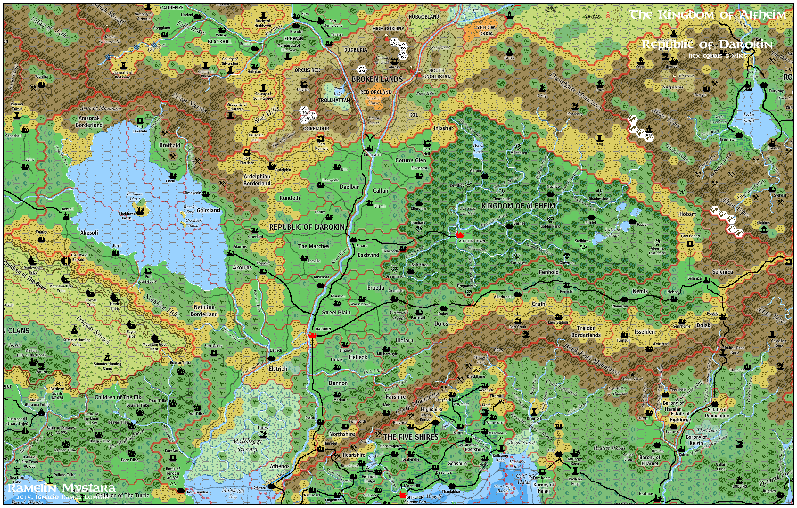
Differences with Canon Material: None
In Ramelin Mystara, Alfheim is virtually unchanged. Only the art. Most notably the Sump and Weir depiction as well as the good and bad magic points that were depicterd as “power sites”.
Atruaghin Clans
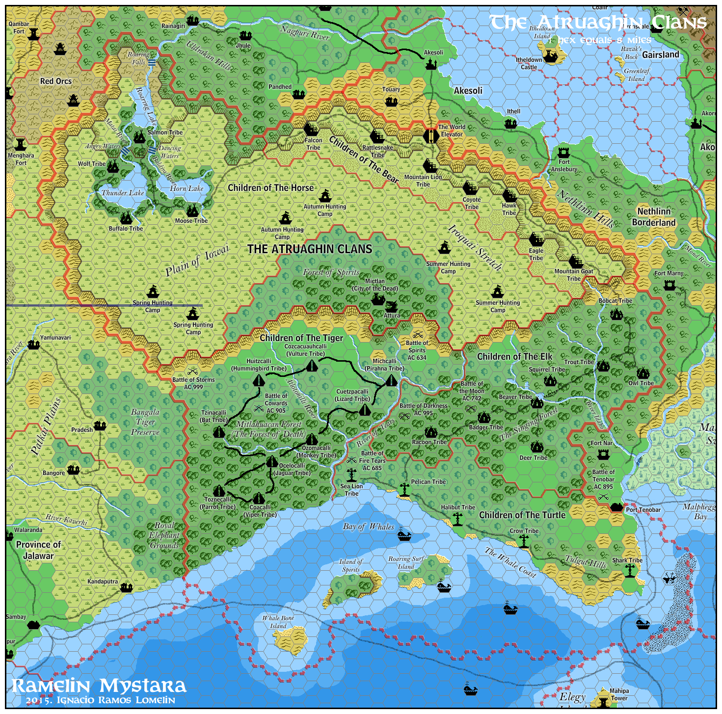
Differences with Canon Material: the clan placements have been shuffled. Added Geographical features.
The Atruaghin Clans is one of the least liked of the Gazeteer realms. I don’t like it much either. I believe it was not done with care as other Gazeteers were. My modifications are as follows:
The children of the Tiger/Viper have been shuffled to the western lowlands. (Otherwise they would be a major source of strife to Darokin, and this is hinted in neither Gazeteer). I added aztec names as well as a river to separate them from the children of the Elk.
The reclusive children of the Elk have been moved to the lowlands nested between the plateau, Darokin, Tiger land, and Turtle land. I added some rivers for the namesake of the Beaver and Trout tribes.
The Children of the Turtle have been given a coastal strip. (having them all on the coast with miles and miles of unoccupied land as in the cannon material seems illogical to me). I also detailed a little the islands off the coast.
I have set the Palace of Atruaghin (Mictlan) on the plateau, in what has been named The Forest of Spirits.
I added the Nagpuri River draining from the lakes, where the Children of the Horse dwell.
The children of the Bear now live on a series of plateaus
I have shrunk a little the borders. The border now follows the contour of the plateau more closely. The broken lands on the northwest are now the home of Red Orcs.
As always I have named a lot of geographical features,
Darokin, Republic
Differences with Canon Material: Changed Heartland borders. Added villages and names.
In Darokin, I believe the Malpheggi Swamps, and the Dwarfgate Mountains should NOT be heartlands. These are clearly untamed borderlands. Furthermore, I have set the Streel River as a border for many of the heartlands as is is probabbly hard to Ford or cross. It is therefore not practical to have a dominion on both sides of the mighty Streel. I have also added villages to some of the Heartlands to make them a Little more civilized.
Ethengar Kahnates
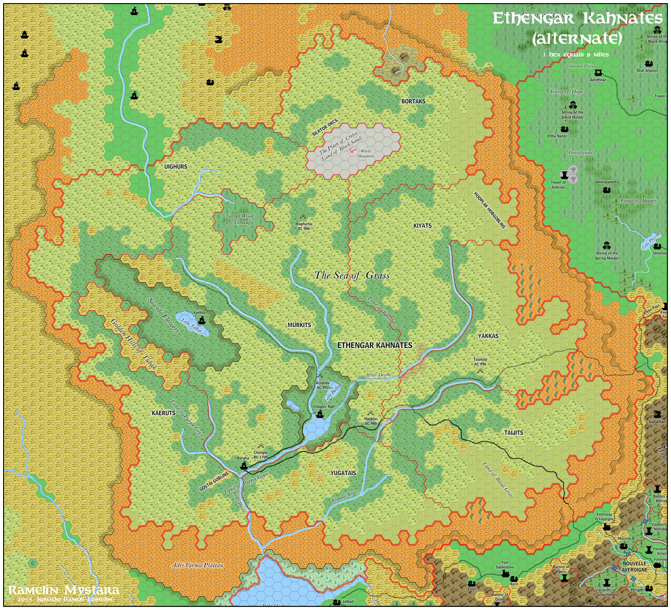
Differences with Canon Material: Relocated to the Adri Varma Plateau
I do not believe oriental settings belong on the Known world. Oriental settings should be, at best, on the fringes of the setting. Therefore Ethengar (along with Ylaruam) have been relocated to the fringes of the known world.
The Ramelin Ethengar is still a threat to Glantri, only it now comes from the west, not the east. On the Plateau, the hordes have more space to expand, (to the north, or into Glantri or Wendar). I have tried to leave the geographical relations between the tribes mostly unchanged. I have added sacred lands for all three of the Ethengarian Immortals.
Five Shires
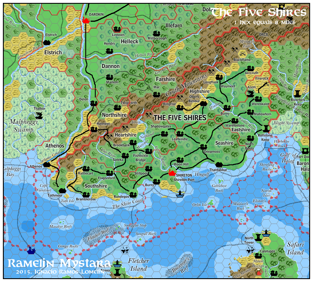
Differences with Canon Material: Mostly unchanged. Added some names and some mines.
The five Shires in Ramelin Mystara are mostly unchanged. I have added many names to the offshore features, as well as some mine symbols on Highshire and Heartshire, as the gazeteer descriptions suggest. Otherwise it is a small land with little room for detailing.
Glantri, Principalities
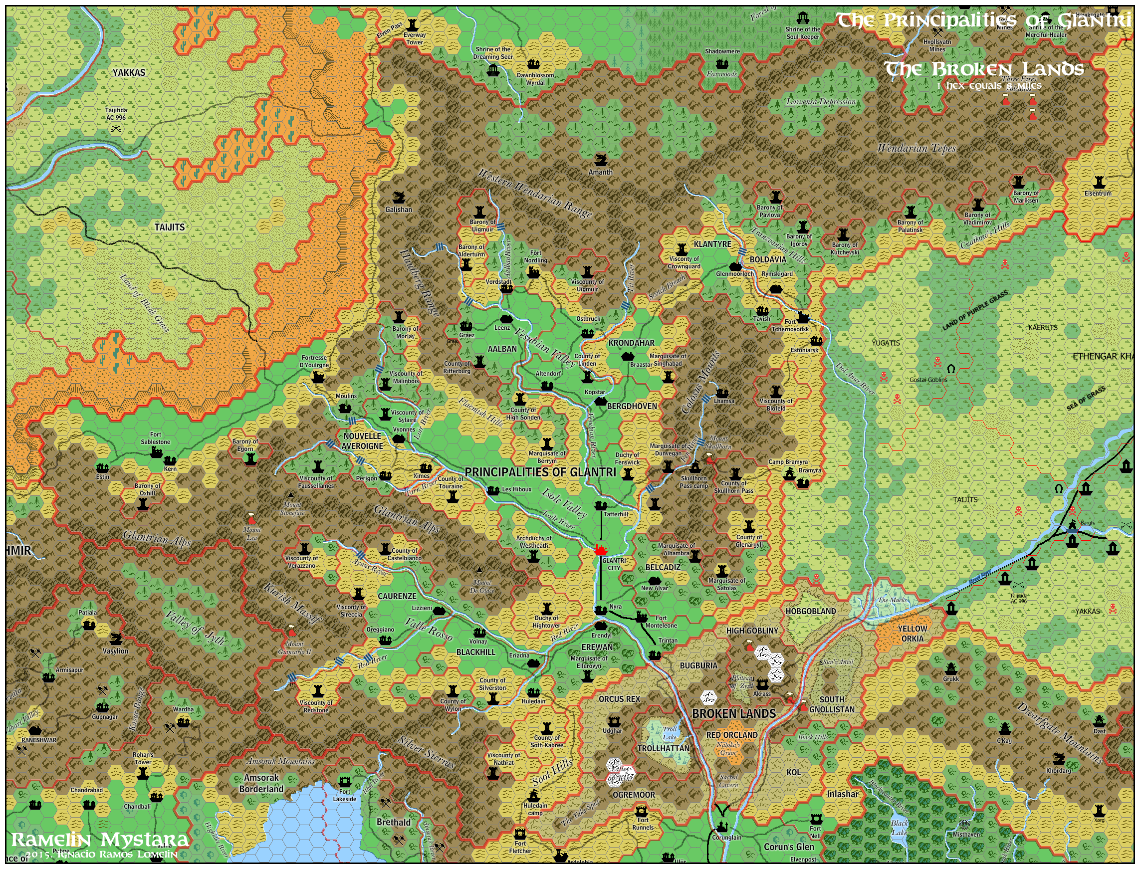
Differences with Canon Material: Modified and moved some of the dominions and national borders. Tweaked slightly the geography.
Glantri was one of the first gazeteers, so the mapmaking was a simple matter of converting 24 mile hexes to 8 mile hexes, therefore it is not very organic.
In Ramelin Glantri, the principalities have inceased in size, as well as other dominions. Klantyre has shifted position just across Boldavia.
Tree hexes, and mountain ridges have been added and some of the hexes have been tweaked to give the setting a more organic feel. A hidden valley has been added (Valley of Jyth)
I have named clearly all dominions and geographical details.
One additional note: the Order of the Radiance is still strictly adhered to. No wizard tower is nearer or farther to the capital than the tradition demands.
Heldannic Territories (work in progress)
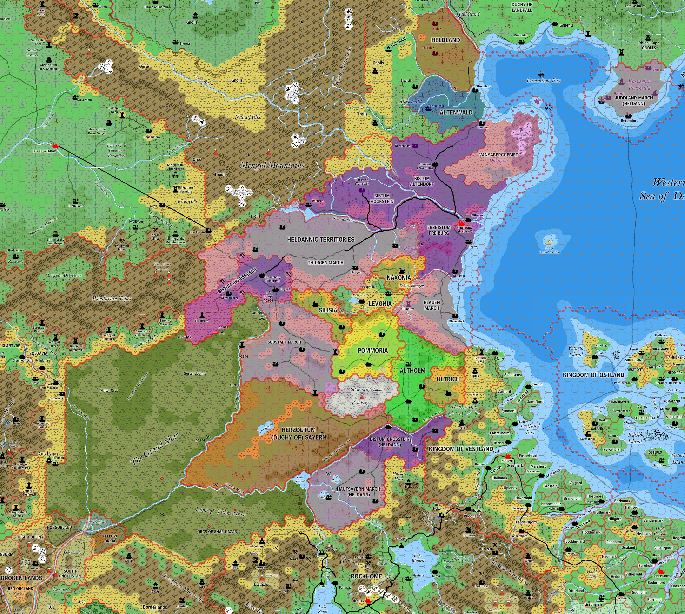
Differences with Canon Material: Vastly expanded into former Ethengar. Added many petty realms inspired in the historical Teutonic Knights State that ruled in the Baltic sea.
Many many changes. These territories are in an ongoing process of unification by the Heldannic Knights. Some states are heartlands, others are protectorates, lawless territories, allied nobles and stubbornly independent states.
The expanded orclands are a thorn on the side of both the Heldannic territories and the Glantrian Princes
Ierendi, Kingdom
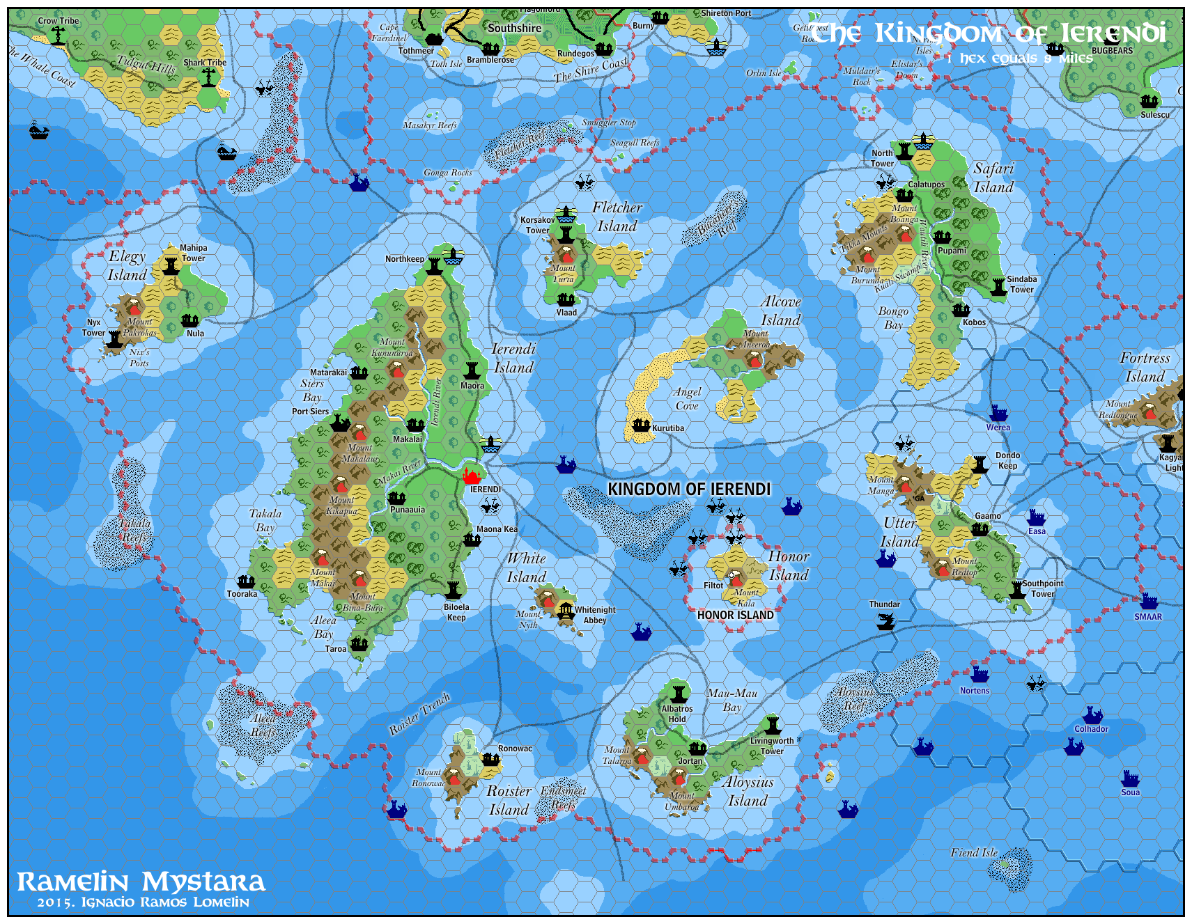
Differences with Canon Material: Mostly unchanged. Added many geographical labels and part of the kingdom of Undersea.
The kingdom of Iererndi is mostly unchanged. I am not especially fond of the Touristic-Magnum PI-Fantasy Island tone of the setting but any changes to the setting have no big effect on the map.
I have added many geographical labels. I have also added a border for Honor Island (an independent nation as per canon). I have also added undersea ruins and part of the Triton Kingdom of Undersea (from PC3 The Sea People)
Jaibul, Rajahstan
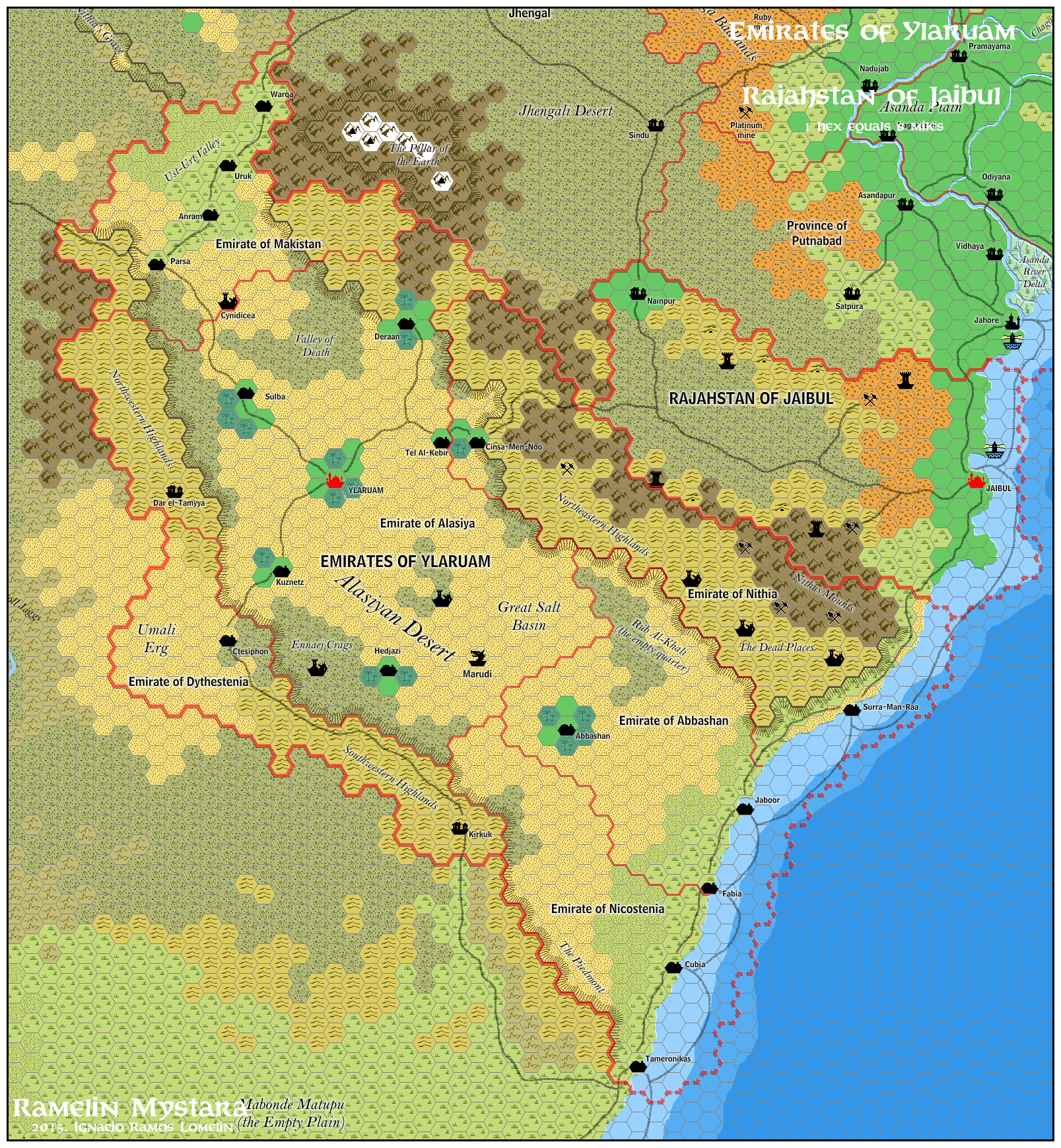
Differences with Canon Material: Added wizard towers
Jaibul is a land of mages. The most powerful is the Rajah of Jaibul, but he is not the only one. Other evil (or at least neutral and uncaring) wizards live in the wilderness.
Karameikos, Grand Duchy
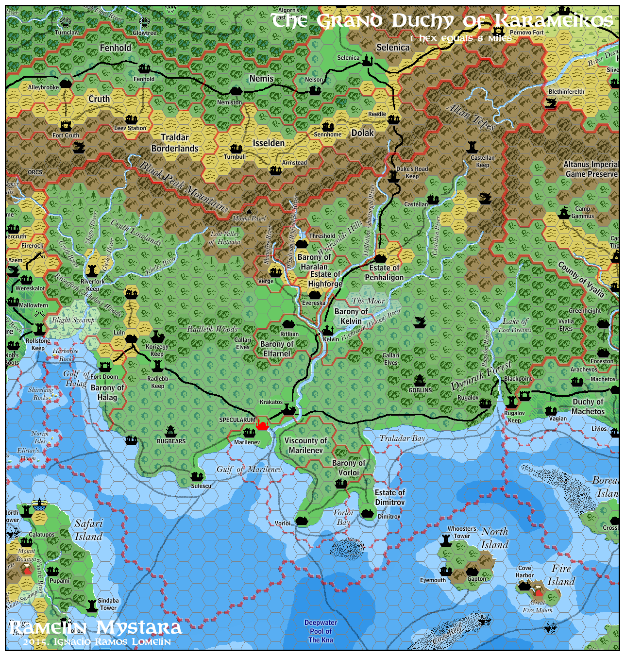
Differences with Canon Material: mostly cosmetic in nature. Added a border.
As the main focus of the known world, The Grand Duchy of Karameikos needs very few changes or modifications. Furthermore it is so heavily detailed that I do not feel I could add to it.
Therefore I detailed mountain ranges, added the border for the barony of Sherlane Haralan (inexplicably absent) and added some geographical labels.
Kohryvian Dales
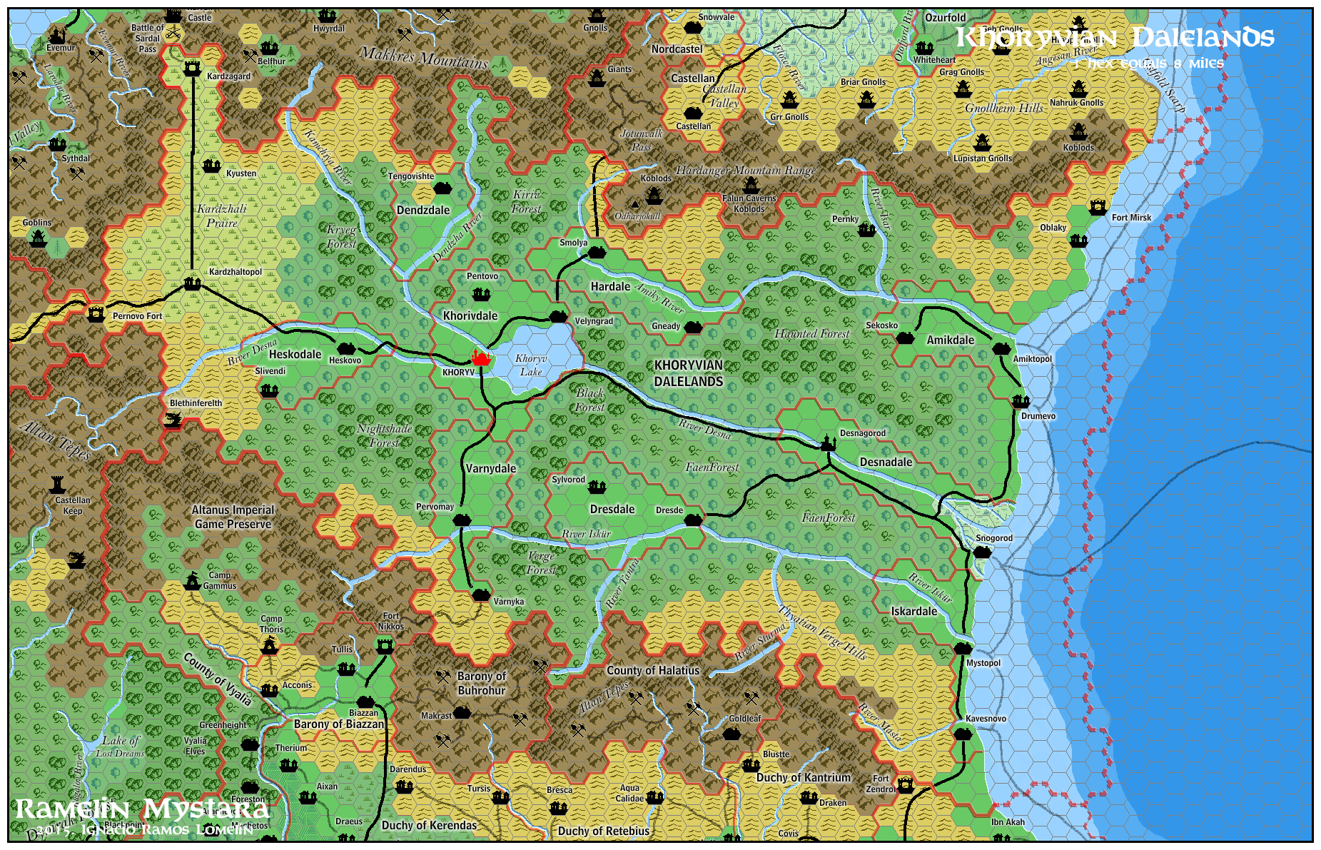
Since Ylaruam has been relocated to the far west of the known world, Ramelin Mystara features a setting not unlike the Dalelands of the Forgotten Realms. This realm is a loosly organized group with an uneasy alliance with the woodland and Fey creatures that inhabit the forests. Some Dales are independent; others lean to an alliance with (or be annexed by) bordering Thyatis.
Eastern Dales are more influenced by Thyatis and more inclined to become Thyatian (maybe the Tel-Akbar peninsula was in the past, part of the Dales.
Fey creatures in the forests have limited the growth of the dales, as well as incursions by thyatian armies.
The names in the Ramelin Kohryvian Dales are loosely inspired in Bulgarian names.
Minrothad Guilds
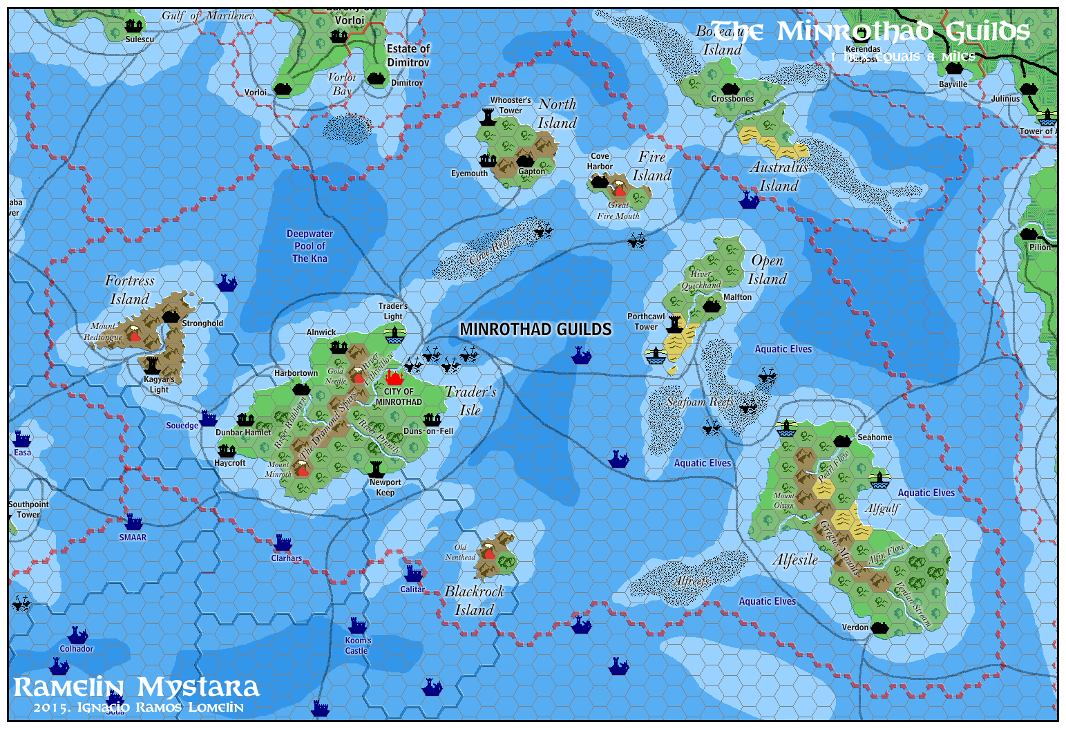
Differences with Canon Material: Mostly unchanged. Added many geographical labels and part of the kingdom of Undersea.
The Minrothad Guilds are mostly unchanged. I have added many geographical labels I have also added undersea ruins and part of the Triton Kingdom of Undersea (from PC3 The Sea People)
Ostland, Kingdom
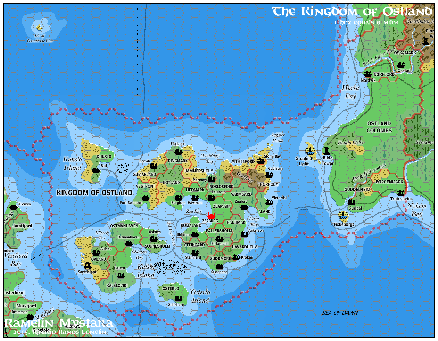
Differences with Canon Material: Expanded borders, and detailed.
Gaz7 states that Ostland has colonies on the Isle of Dawn. Therefore, with the approval of the Thyatian emperor, Ostlanders have begun to settle on the Isle of Dawn. Ramelin Ostland has these colonies set on map.
I have also integrated the excellent work of Jacob Skytte, from the Complete Domains of Ostland 1st Ed, on Vaults of Pandius.
Rockhome, Kingdom
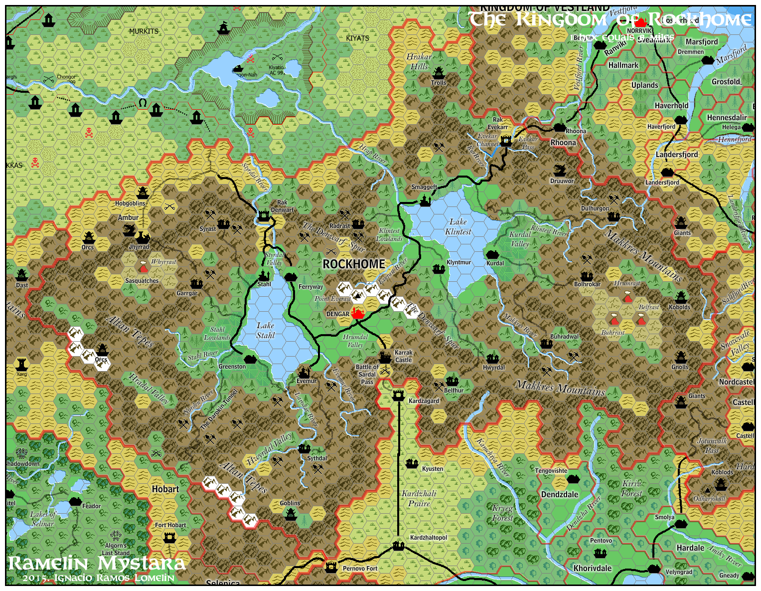
Differences with Canon Material: Mostly unchanged. Heavily detailed with villages, dwarven names, and mountain ridges.
Ramelin Rockhome is formed like a double bowl, with mountain ridges circling the realm. I have also added more villages, and mining sites (the original has no mines! Dwarven mountains should be teeming with mines!) Villages, Geographical features and other labels have been “invented” using the dwarvish dictionary from GAZ6.
The valleys now feature a farmland symbol, which I use on heavily farmed areas such as these valleys, or for instance, the five shires.
I would also like to point out that I separated the Vestfjord River from lake Klintest and added a Dwarf made Channel to link both waterways. It seems to me that a dwarven engeneering work was due here.
Sindh, Kingdom
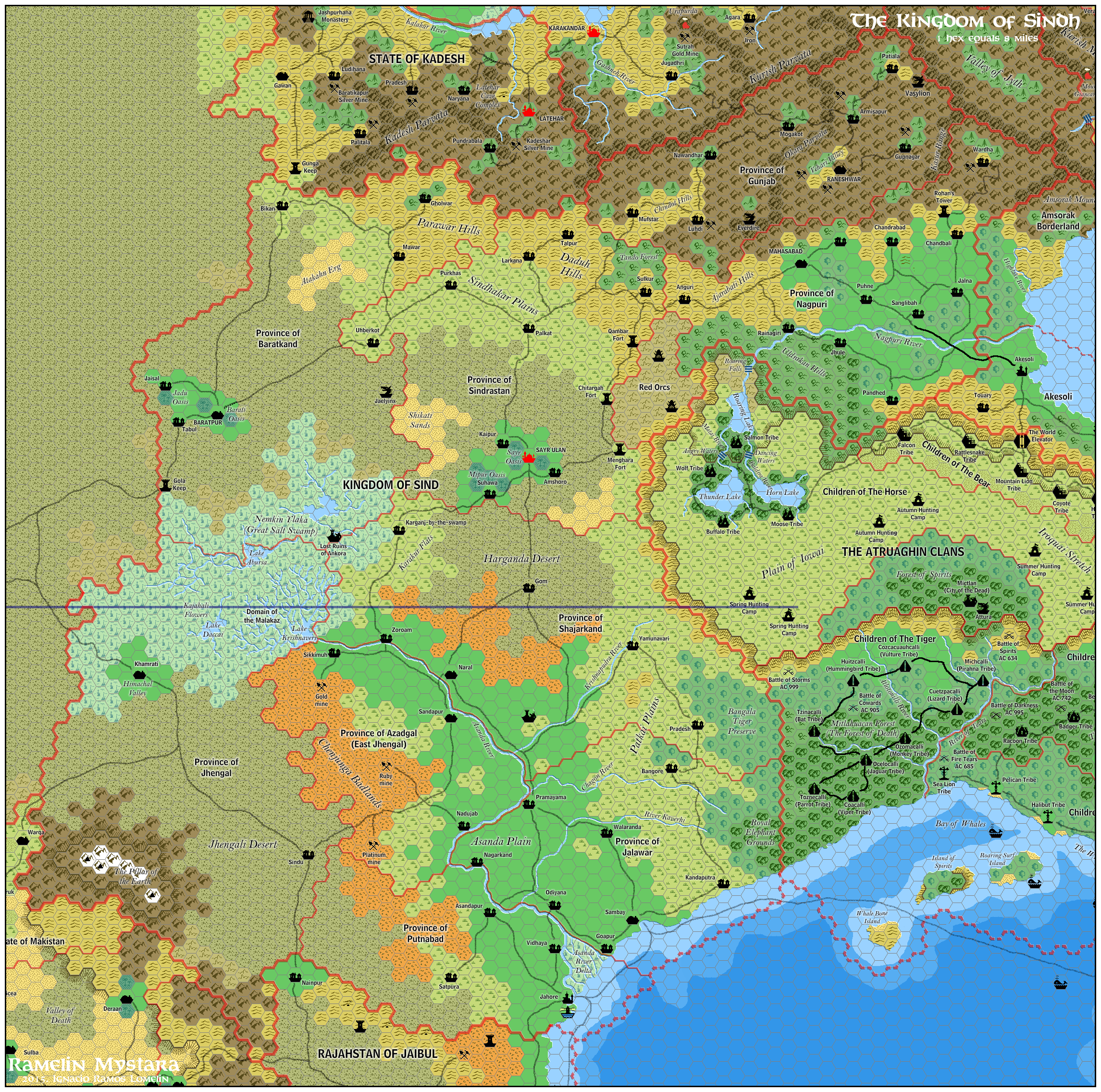
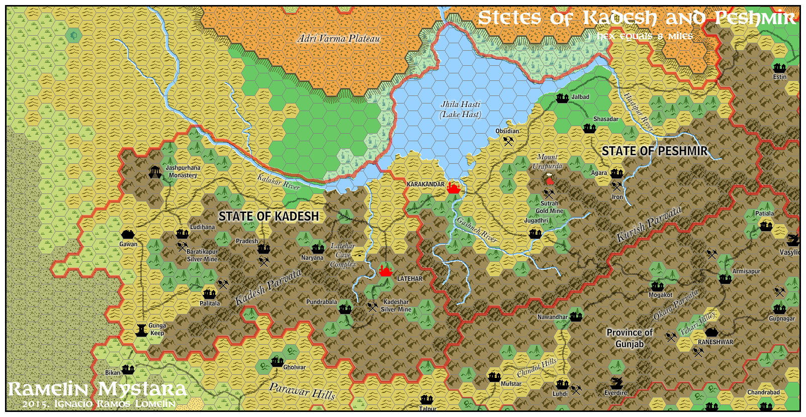
Differences with Canon Material:
Ramelin Sindh is divided in two: the Kingdom of Sindh proper, and the mountain states of Kadesh and Peshmir. In Ramelin Mystara, Kadesh and Peshmir are mountain states, protected from Sindh proper by high mountain ranges.
Ramelin Mystara Sindh has its borders somewhat reduced. Kadesh and Peshmir are not part of Sindh, and the western border has been shrunk. I do not believe Sindhis would claim so much of a barren rocky desert as the canon material suggests.
Geographically, Ramelin Sindh features many new rivers (the Nagpuri and many tributaries of the Asanda), many new names, villages, roads, mines, and forts. All in all a more populated place than canon Sind.
Soderfjord Jarldoms
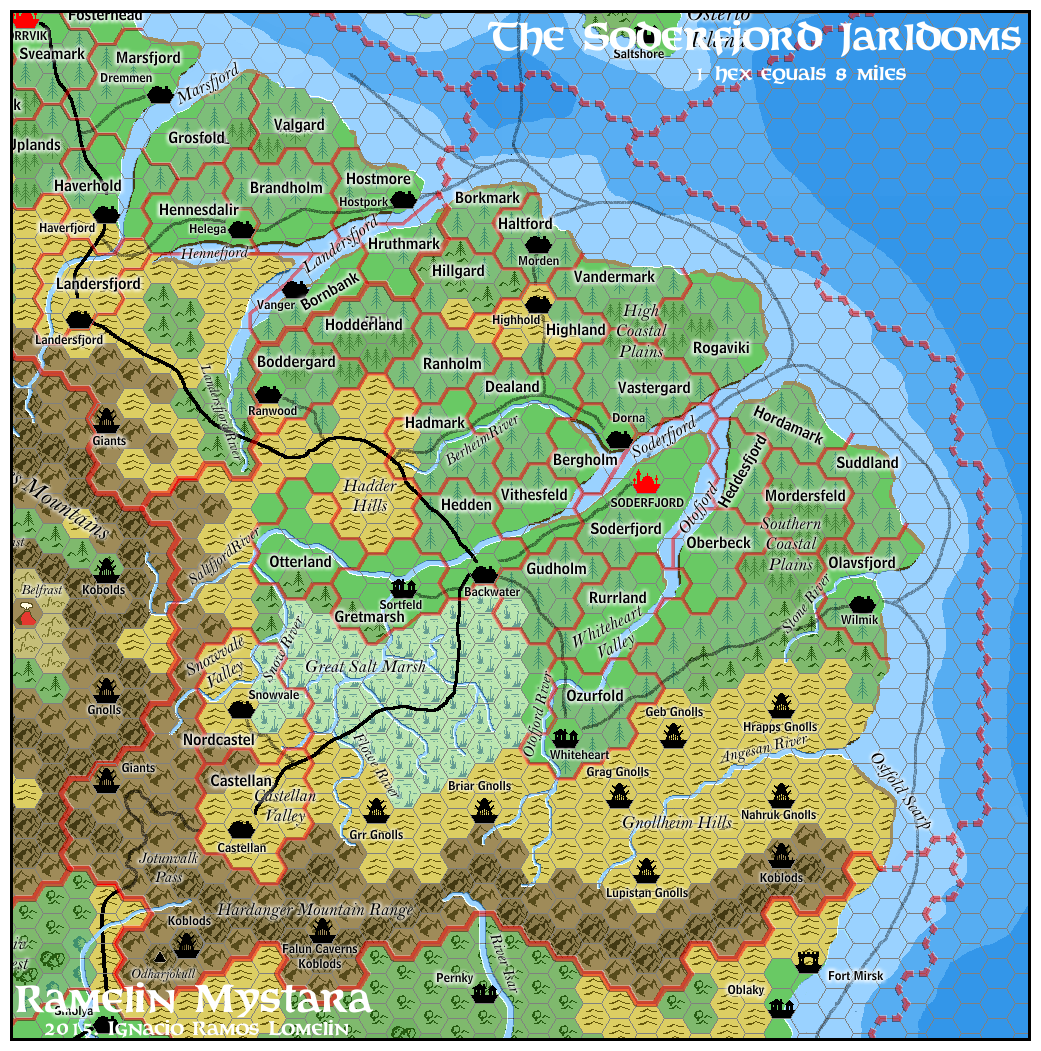
Differences with Canon Material: Mostly unchanged. Added domain borders and names, labels, and humanoid lairs.
This realm is mostly unchanged. I have put some rideges on the Hardanger range, named the Ostfold scrap on southern Soderfjord, and labeled various humanoid lairs (such as Gnollheim gnolls or the Falun cavern Kobolds)
Thyatis, Empire
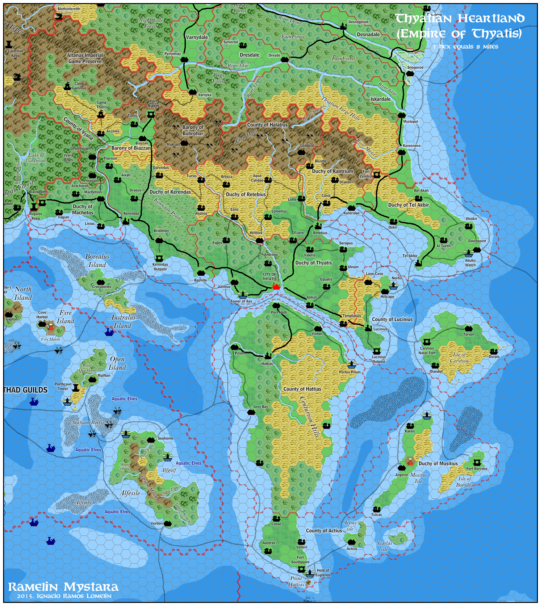
Differences with Canon Material: Major changes in domain distribution. Added villages, towns, and borders.
The Thyatian mainland has been the imperial heartland for a thousand years. This age and power should show. In my opinion, the domains are too small, and there should not be uninhabited territories labeled “imperial territories (and future domains)”. Also, the Thyatian mainland should not be so sparsely populated. So, all things stated, these are the changes to the Ramelin Thyatis:
The borders of the dominions have been expanded. The protectorates are now part of different dominions. Also, of the imperial territories, one has been eliminated and the other has been converted into a game preserve for the imperial family.
Many villages have been added and named in the Thyatian style, and many farmland symbols have been added. The mountains now feature ridges and mine symbols.
I have also changed Terentias island to better accommodate a pirate setting. I am not very happy with this so it will probably change.
Vestland, Kingdom
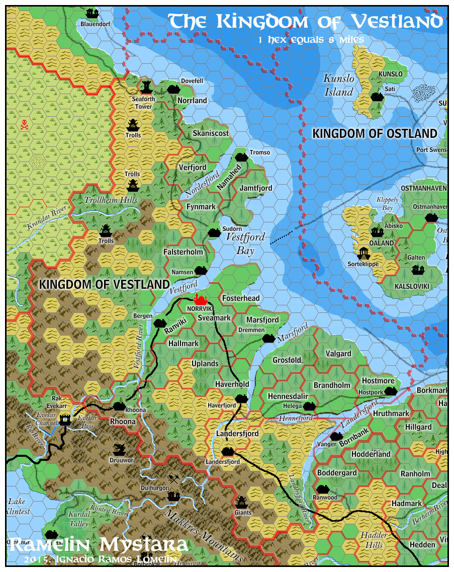
Differences with Canon Material: Mostly unchanged. Added domain borders and names, labels, and humanoid lairs.
Wendar, Realm
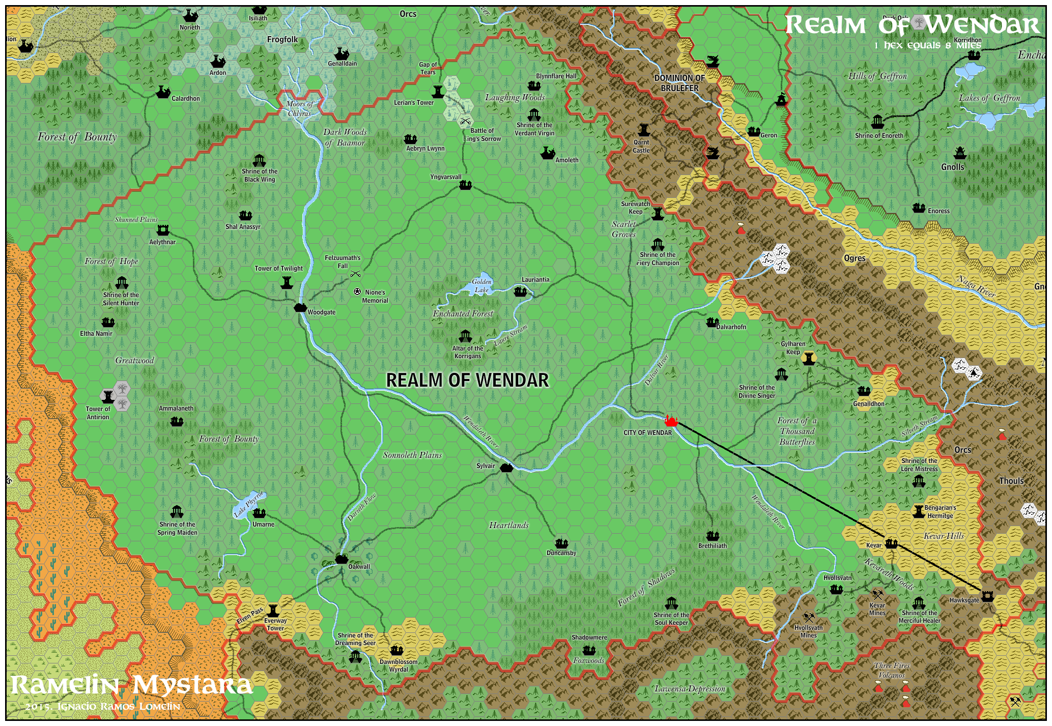
Differences with Canon Material: none
The Realm of Wendar is unchanged from the fan made Gazeteer (GAZ-F) of the same name. The additions are mostly mountain ridges, but these are mostly outside the borders of the realm.
Yavdlom, Divinarchy
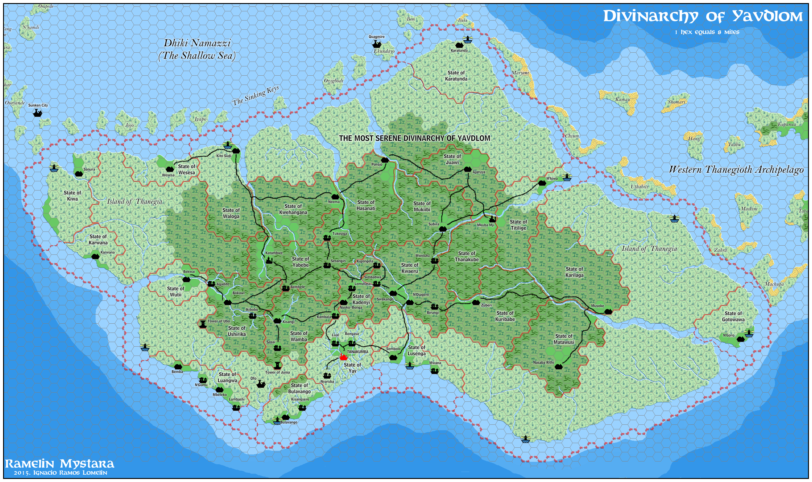
Differences with Canon Material: Borders reduced and States added
The really settled lands on the serpent peninsula are on Thanegia Island, so I have reduced the borders of the Divinarchy to the Island of Thanegia. I have also tried to detail and expand on the material presented on the Princess Ark Series.
The rest of the islands and the peninsula are mostly wilderness (with the notable exception of Ulimwengu)
Ylaruam, Emirates
Differences with Canon Material: Relocated to the coast of the Sind desert
I do not believe oriental settings belong on the Known world. Oriental settings should be, at best, on the fringes of the setting. Therefore Ylaruam (along with Ethengar) have been relocated to the fringes of the known world.
The Ramelin Emirates of Ylaruam have been rotates and fit just south of Jaibul. I believe Ylaruam in this position sparks an Al-Qadim-like setting on the Sind Desert (which has yet to be developed).
I have set a gigantic and very dangerous mountain on the Ylari border (The pillar of the Earth) as well as a dead river valley (Nithia’s Grave). (I have thought that Lake Halli far to the north, near the Black Mountains, should have been in the past, the source of this new River Nithia)
Otherwise, the setting as well as all labels is very similar to the canon material.
Serpent Peninsula
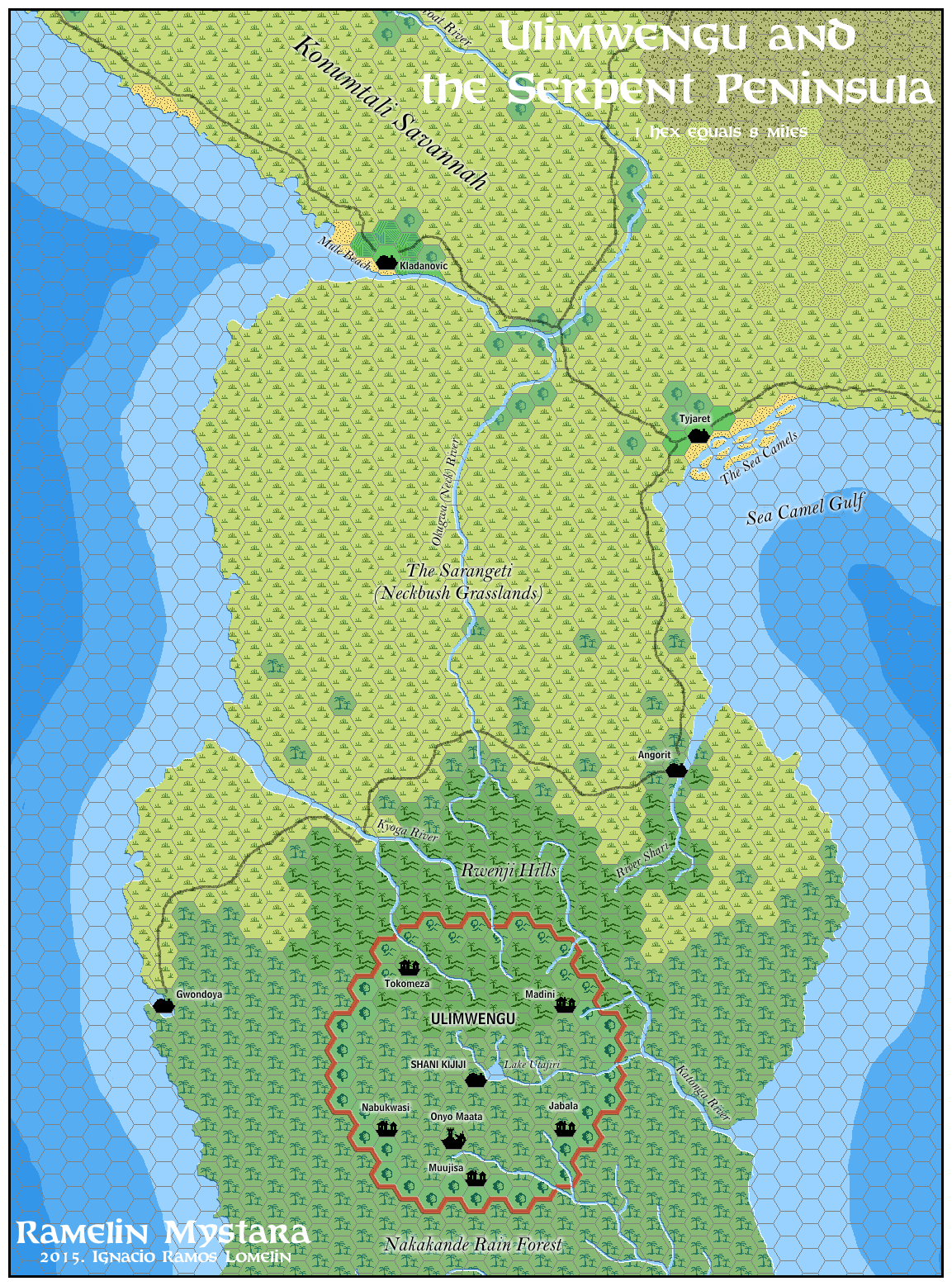
Differences with Canon Material: Minor changes
The Ramelin Mystata Serpent peninsula is just like the canon counterpart, except for:
Ulimwengu has been detailed, adding villages, ruins and rivers;
Yavdlom has been reduced, so the towns on the peninsula are now independent
The Neckbush Grasslands have been renamed The Sarangeti
I have always had a soft spot for the two towns featured on X6 Quagmire!, Sea Camel and Mule Beach. Since these towns have been renamed, I decided to use the original names as geographical features near both towns.
PART II: Western Brun
There seems to be two versions of Western Brun. In one of them, the Zuyevo and Yezchamenid Empires exist. In this version, the Sea of Yalu (The Cradle) and Health's Spring are enlogated and farther south. In the other version the lands near the Yalu River are dominated by the Lawful Brotherhood, Chaotic Sisterhood and Neutral Alliance. The Sea of Yalu and Health's Spring are shaped more like Master Rules Map and are positioned farther north. Moreover, there is no clear position for the Arm of The Immortals in relation to the Orc's Head Peninsula.I have tried to reach a compromise between both versions and the Master Rules Map. In my interpretation the Master Rules Map is a typical medieval map with both truths and errors in the position and shape of the geographical features. The final result is a complete and congruent map which (I hope) creates a seamless whole in the 8 mile per hex scale.
Klagorst
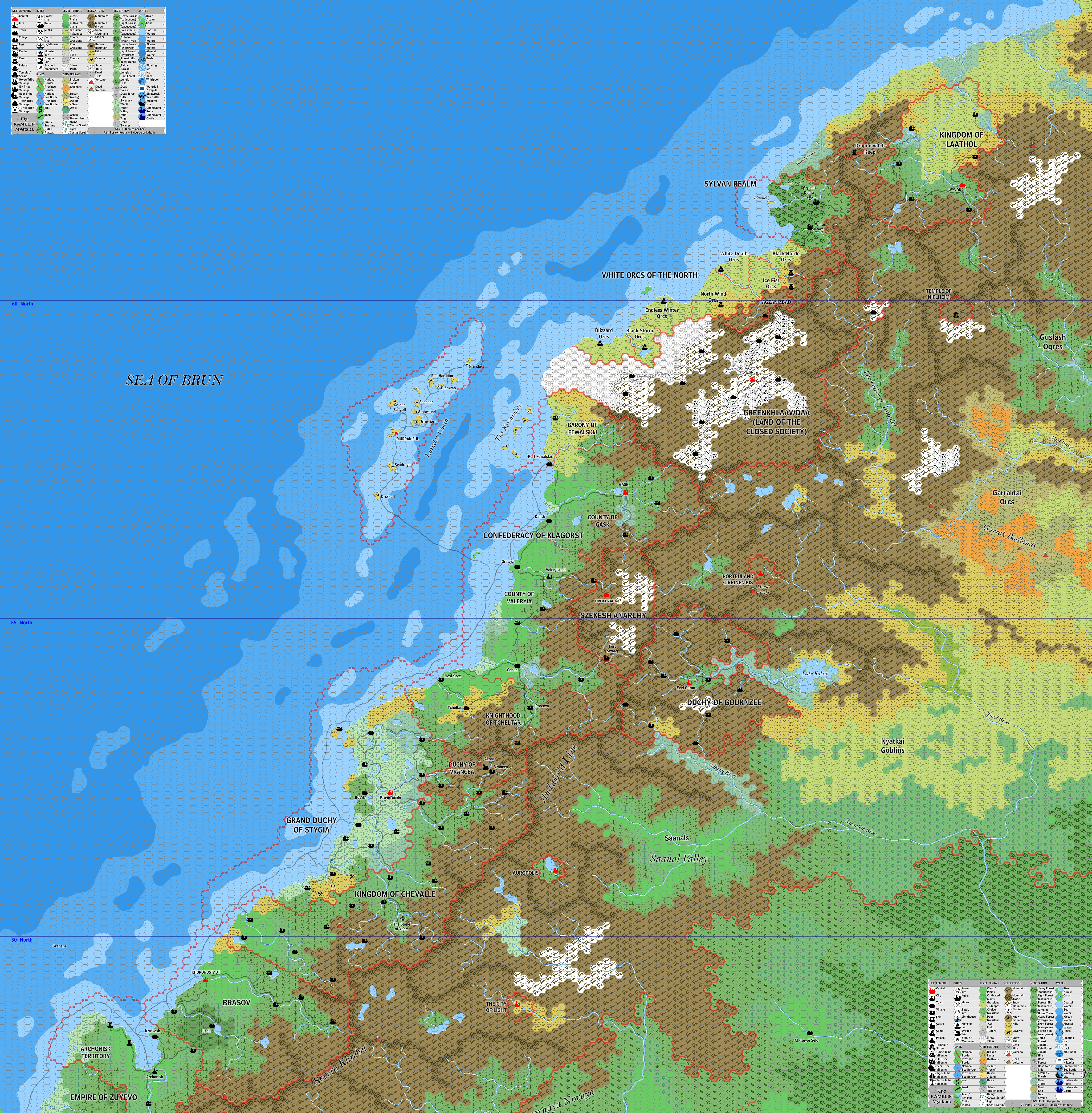
Valhara
Yalu Bay and the Yezchamenid Empire
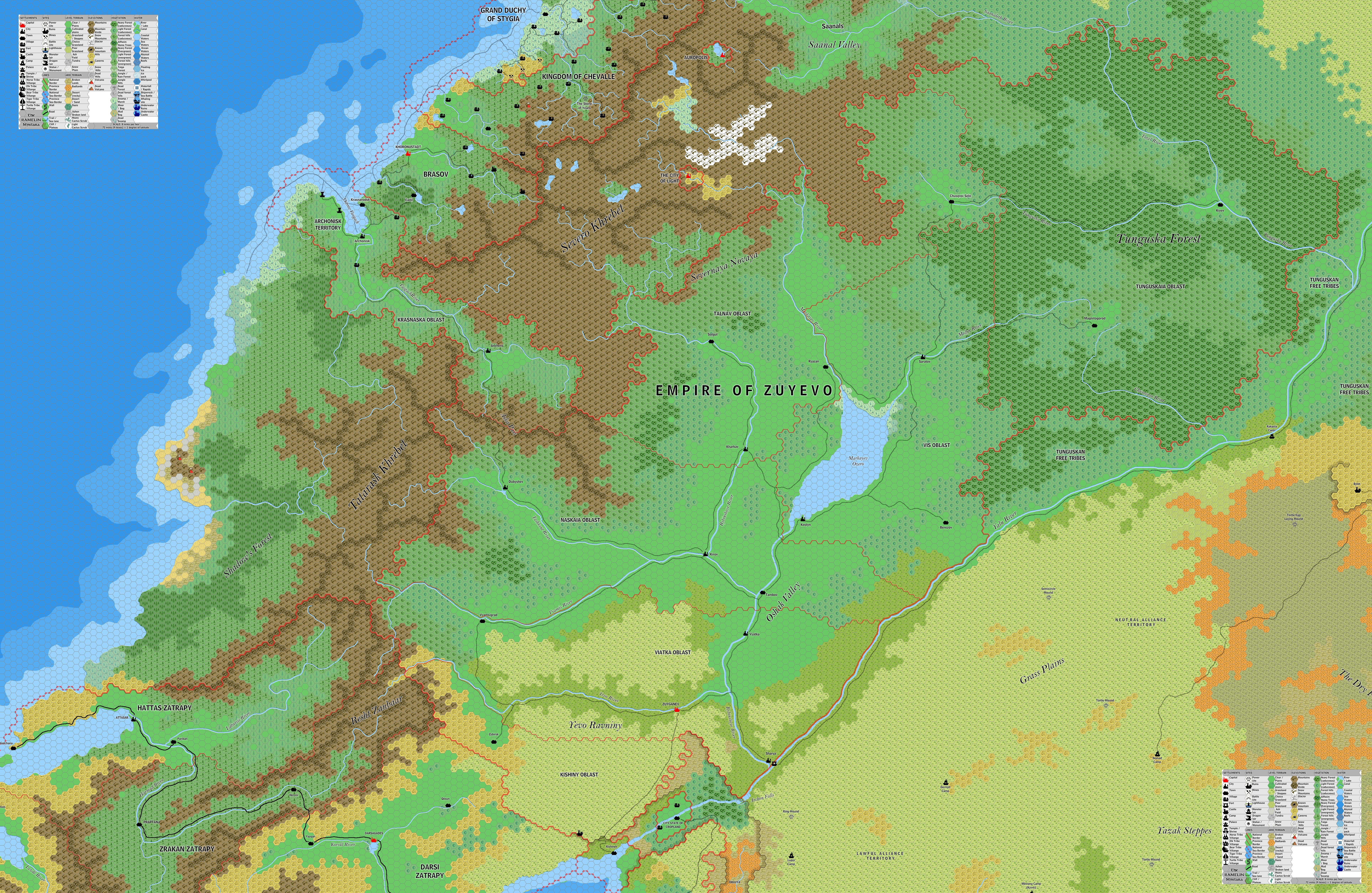
Empire of Zuyevo