
Maps of the Selhomarrian Provinces
by Geoff GanderAnnurios
See Selhomarr, 8 miles per hex
Varannis
See Selhomarr, 8 miles per hex
Regelnis
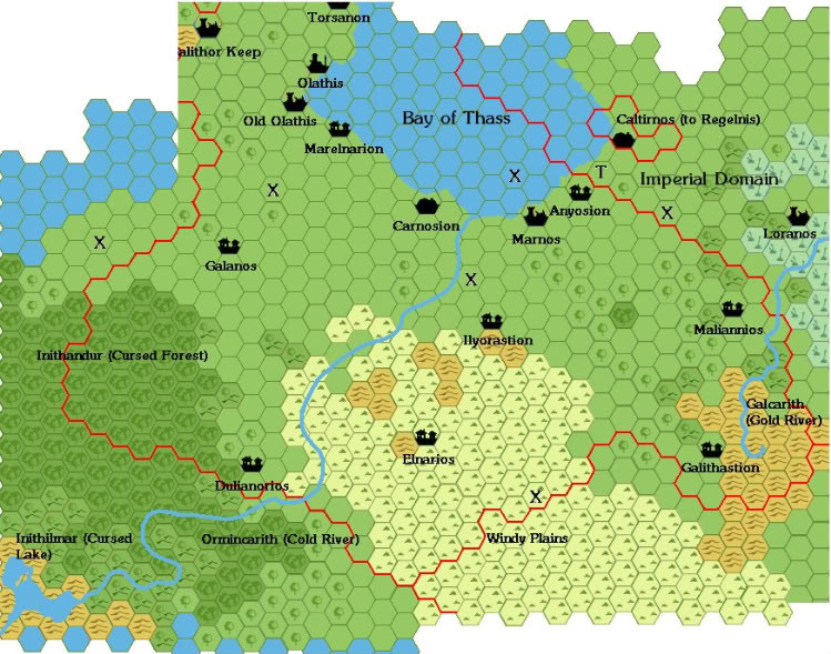
OK - now the notes....
- All of the Xs are battle markers (all from the little civil war that happened here)
- The T is intended to be a tower
The road from Olathis continues along the coast of the Bay of Thass, passing through every settlment (including the ruins), over the border and on to Caltirnos. From there it will likely go to Calimnis.
As for trails, on extends from Carnosion to Ilyorastion, and from there to Galithastion. Around the latter, we'll need a mining symbol (there's some gold in them thar hills - hence a trail). Maliannios is connected to that trail. There's also a trail from Ilyorastion to Marnos (that place is a real way-station). A trail also splits from the road out of Marelnarion to connect to Galanos, and from there to Dulianorios.
Looking at the map again, I think it makes sense to extend the border due south of Dulianorios to the Cold River (just those three hexes), as that would make a natural boundary.
FWIW, I imagine that the Cold River originates in the glaciated peaks of the Lhomarrian Range, descending in several cataracts down to the hills, where it collects in one or two lakes before draining via the river.
Imperial Domain
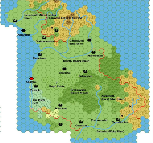
P=Palace symbol
F=fortress
Notes:
-Belcarith forms part of the external border of the empire.
-Senercarith forms part of the border with Soroth (I forgot to add a battle marker there - anywhere close to the border would do).
-The rest of the border with Soroth is marked by Gorimcarith and Ilcarith.
-I may have overshot the coastline in the west (where Ilyoris province would be) - feel free to prune as necessary.
-I'll name the settlements in Ardeth and Soroth later.
-The River of Sorrow should read as "Iltarcarith" ("t" shouldn't be capitalised).
-We'll need a road from Calimnis that follows the shore, going through all the settlements along the way.
-A trail goes from Gorimnastion to the village in Soroth, and from there generally northwards until it goes off the map.
-Another road goes from Calimnis to Ilbarathis, and then to the town in Soroth.
-A trail goes from Ilbarathis to Belanorion, then to Marbrethion (which probably goes to the town in Soroth as well, or it joins the road - whichever looks better).
-A trail goes from Calimnis through Pesinnir, and from there to all the other villages (and the fort), ending at the mines. A side trail heads down to the village in Ardeth.
**Thorf, if the image is too small, I can email you the original file.
Tynerii
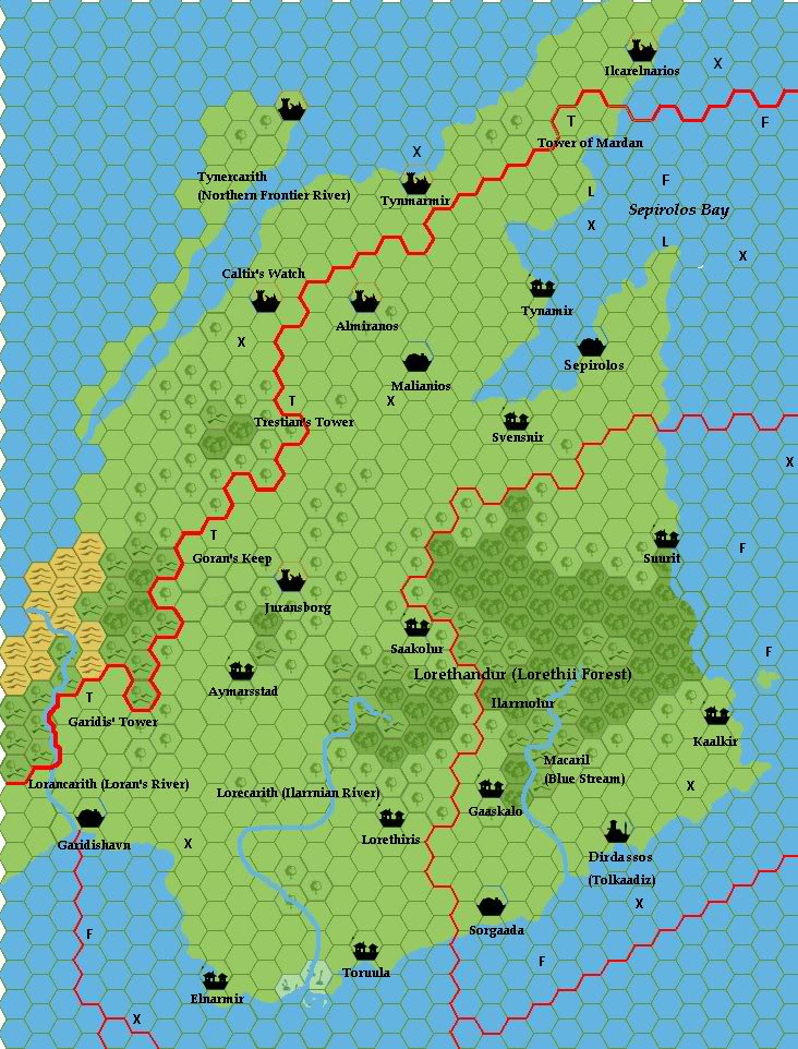
Here is the link to the latest part of the map - notes are as follows:
F= good fishing hex
L= lighthouse
T= tower
X= land battle or shipwreck/sea battle
I didn't extend the map all the way "east" because I wanted to focus on Selhomarr itself, rather than detailling as yet unclaimed land. I did, however, drop in some coastline for the other side of the Northern Frontier River. I looked at Thorf's map and decided that this river should be more of a fjord, very wide towards the mouth, but narrowing to river proportions at the source.
As for other details, I think it would look neat if the shores of the Frontier River could be marked with cliffs, to make the land really stark. I envision the whole province to slope downwards from those cliffs to the sea in the south.
The place names reflect the Antalian influence of the region, as per the Gaz. Tynerii is really a pretty funky place, very much on the frontier, where settlements are small, and the woods contain monsters.
As for roads, the main one goes from Garidishavn all the way to Sepirolos, passing through Aymarrstad, going between Saakolur and the ruins of Juransborg, and through Svensnir. Another road goes from Svensir to Malianos, and then to Tynamir (frequent raids require good roads between settlements). From Tynamir a trail runs to the Tower of Maradan.
Trails run from Malianos to Trestian's Tower, from Goran's Keep to Aymarsstad, and from Garidis' Tower to Garidishavn. Trails also connect Aymarsstad and Saakolur to the main north-south road.
A second road runs along the southern coast, from Garidishavn through Elnarmir, Toruula, Sorgaada, and ending at Dirdassos. Trails run from Dirdassos to Kaalkir, and from Toruula to Lorethiris and Gaaskalo and joining the road next to the river. Another (dangerous) trail connects Suurit to Sepirolos and Kaalkir.
Ardeth
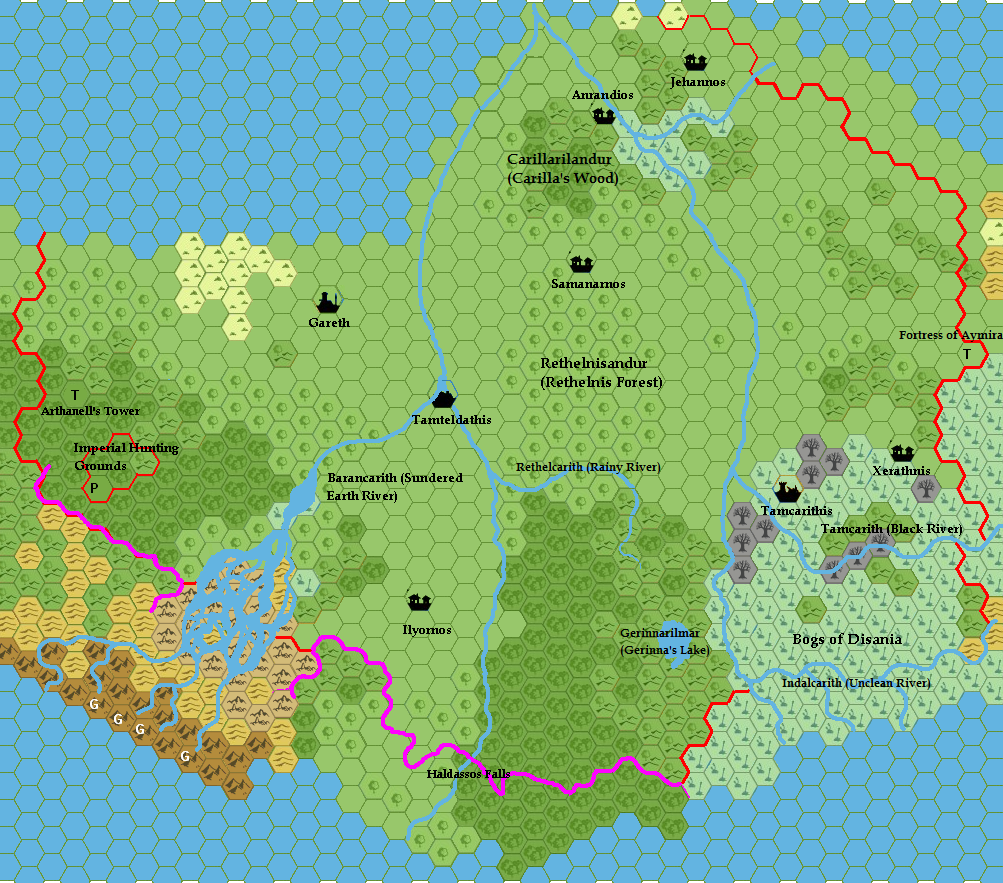
Some explanatory notes are in order:
- The purple lines are meant to be the line of an escarpment, which forms the southern border. Some time in the distant past (but after Selhomarr was created) there was a great earthquake in this region, which caused a large portion of the escarpment (which formerly ran roughly diagonally) to collapse. Hence the broken lands hexes. After the land subsided, and new river courses were carved, much of the resulting lowlands filled up, creating a mass of rivers and tiny islands. I haven't decided where Selhomarr's border would run in this part - perhaps it would follow the mainland.
- In the swamp, the border follows the Unclean River, and part of the Black River further north.
- A trail runs from Garith to Tamteldathis, and then to Ilyornos. A second trail runs from Tamteldathis to Samanarnos, then Anrandios, Jehannos, and then joining with the existing trail created for the Imperial Domain map. A third trail runs from Jehannos to the Fortress of Aymira (that should be an actual fort, not a tower), and from there to Xerathnis. Finally, there's a trail running from Gareth to the Imperial Hunting Grounds, which needs a palace hex at the P.
- The Bogs of Disania ebb and flow over time. Currently they are growing (despite efforts to drain them), which explains the dead tree hexes.
- I'm toying with the idea of turning the northern swamp into a bit of a sinkhole, in which case (correct me if I'm wrong) the forested hill hexes could be edged in low escarpments. This would create a low-lying region where the river collects a bit and becomes stagnant. Then, I'd like to have a couple of mushroom forest hexes replace a few swamps. Yep - giant shrooms, thanks to a combination of weird minerals, and the SoP (some Immortal whisked some giant shrooms from the surface world and deposited them here - long before Selhomarr appeared). Just thought it would be a cool feature.
Soroth
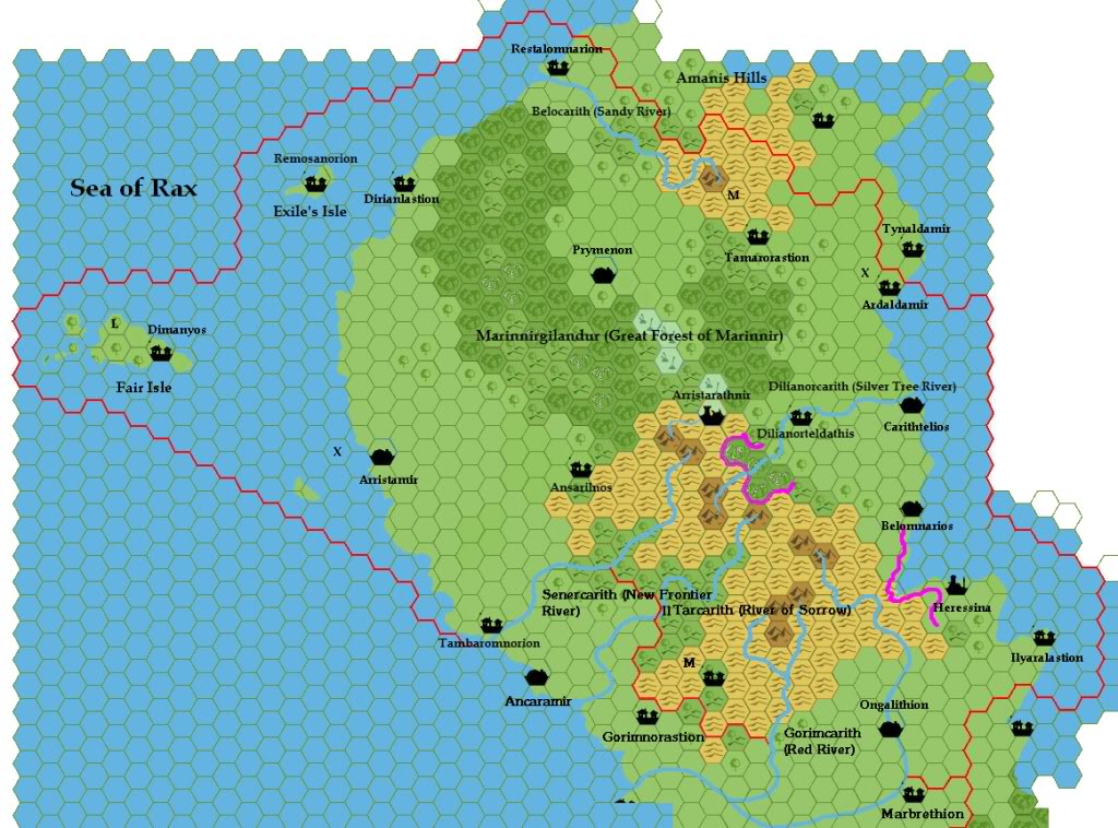
The coastal road from Ancaramir passes through Tambaromnorion (already done) to Arristamir, and then goes inland to Prymenon, then back to the coast at Restalomnarion (crossing the river there). It will continue into Atlissini, but I’ll need to draw up that map to plot the route.
There are trails from Restalomnarion and Arristamir to Dirianlastion. There is also a ferry route from the latter village to Remosanorion. Dimanyos has no regular connection to the mainland (and they like it that way).
Ansarilnos is connected to the coast road by a trail.
The trail from Gorimnorastion, which passes through Tamanithasios (forgot to name it on the map), continues to Dilanorteldathis, and then to Carithtelios.
The road from Ongalithion (now named) runs to Heressina. The road will follow the coast to Ilyaralastion and points further west. It should also go north, probably staying above the cliffs, to Belomnarios, Carithtelios, and the two villages further north.
Another trail connects Ardaldamir to Prymenon, by way of Tamarorastion.
Ilyoris
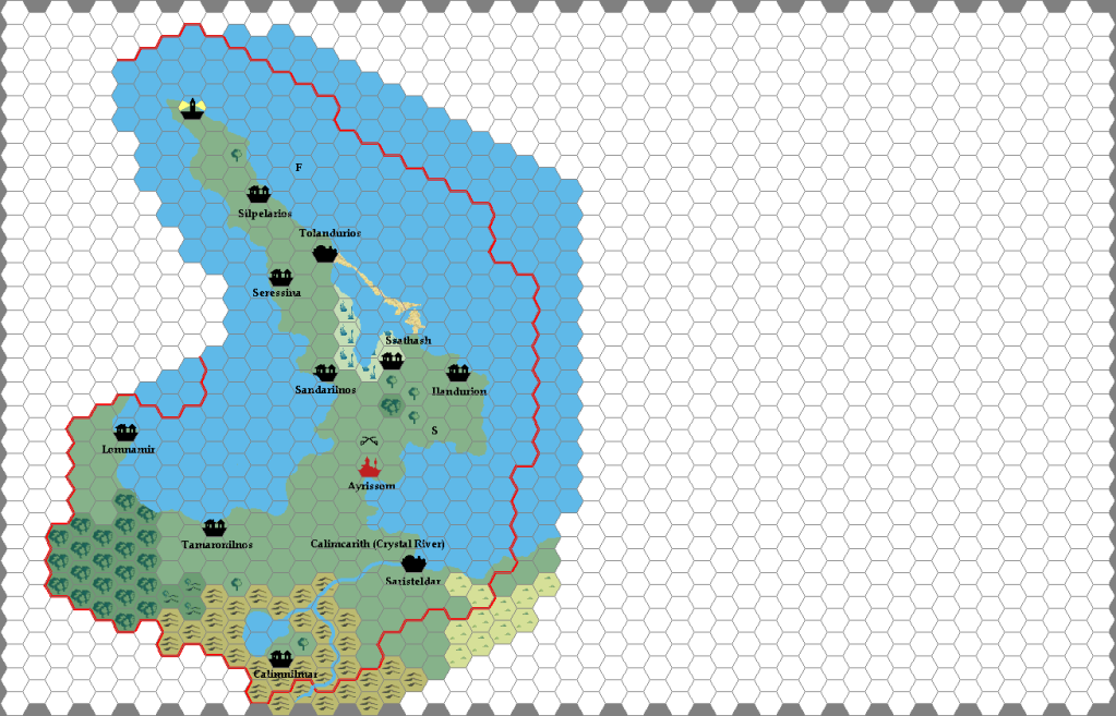
Map notes are as follows:
The coastal road from Ilyaralastion (in Soreth) passes through Lomnamir and Tamaronilnos on the way to Ayrissom. There it branches, with the southern route heading through Saristeldar and then following the coast into Akalis province. The contentious northern route heads due north (through the battlefield), then turns "west" towards a giant statue (the "S" on the map, intended to be replaced by the statue marker from the Milenia map) and ending at Ilandurion.
A trail heads northeast from the battlfield to Sandarilnos, and then to Tolandurios, with a side trail to Seressina from the town. Silpelarios is literally the end of the line.
A little-used trail connects Saristeldar to Calimnilmar (whose name is an in-joke based on a series of popular slasher flicks from the 80s, which will eventually be reflected in an adventure hook if I get around to it).
F denotes a goodf fishing marker. I think we'll need a couple more.
Ssathash is not connected by any roads or trails, and that's how the human population likes it.
Akalis
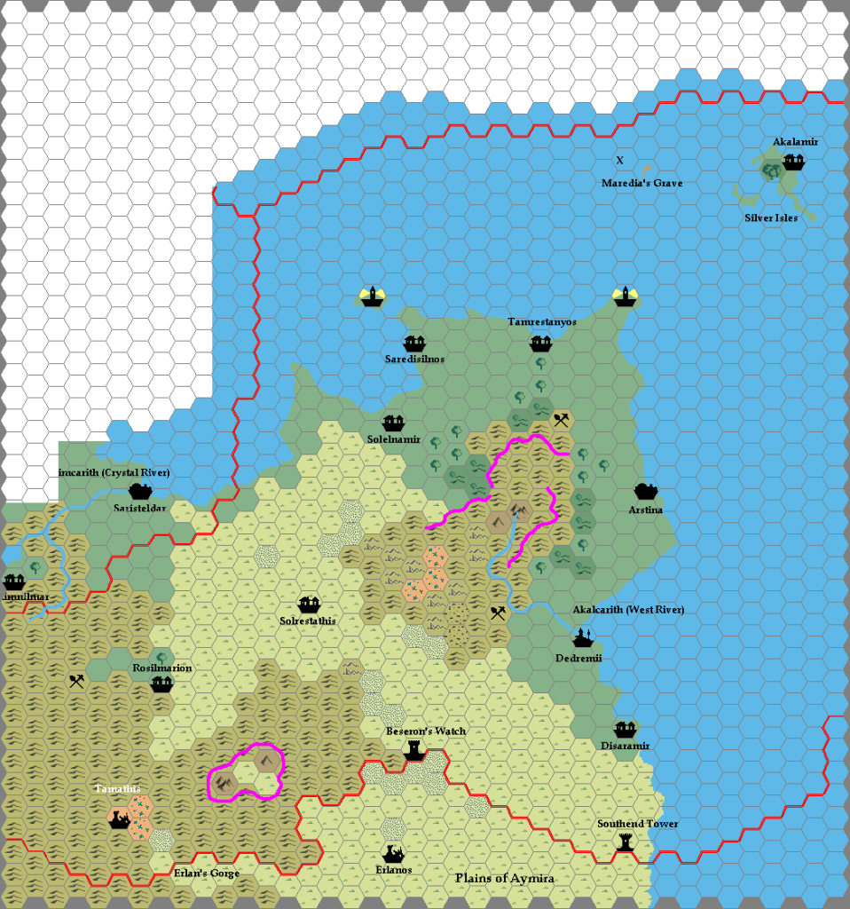
And now for the notes:
- The coastal road from Saristeldar in Ilyoris crosses into Akalis and heads straight to the forgettable village of Solrestathis (lit., "dwelling of little water"), the only place for miles around that has accommodations or decent supplies of water. From there, the road continues southwest through the gap, and then follows the line of the hills northwards towards Dedremii, where it ends.
- A second road heads north to Arstina, but after that it is reduced to a trail, passing through all the villages. From Solelnamir, the trail joins with the main road before it dips down to Solrestathis. There are also trails from Tamrestanyos to the nearest mine, and from the road to Dedremii and the nearest mine.
- There is a coastal trail from Dedremii to Southend Tower, passing through Disaramir.
- There is a side trail from the main road to Beseron's Watch.
- There is a trail from Solrestathis to Rosilmarion, and from there to the mine.
- The forest on the Silver Isles should be coloured white.
- As on other maps, the purple lines denote escarpments.
- and finally...the X should be replaced with a shipwreck.
Atlissini

F=good fishing place
S-sunken ships (lots of naval battles with the Antalians around here, which explains why the coasts have basically been abandoned, outside of walled towns)
The eastern coastal road from Soroth (Restalomnarion) continues north to Gorimbaramir, and then goes inland straight to Xirenyos (with a side-road to Solgalithios. The road then splits, with one branch heading due north, through one of the Twins, to Prenos.
The other branch heads west, hugging the coast, passing through Sorathis (with a side road up to the other Twin), and then to Nevora. This branch also splits a few hexes outside of Xirenyos, just south of the battle marker, with a road heading south to Ilaprymendion (hugging the hills), and then south off the map to connect with Tynaldamir. So, you can do a nearly complete circle around the Tylierian Peninsula (cart races, anyone).
As for the trails, Indalrestion is connected to the north-south road, and from there is a (highly unsafe) trail hugging the coast to Orestian’s Tower. There is another trail to the ruins of Baranrothnios, but this is most often used by adventurers (and often one-way at that). Solgalithios is connected to the nearest mine with a trail, as well. Prenos is connected to the lighthouse by a trail.
There have been efforts to connect Orestian’s Tower with the Twins, but the presence of monster-infested caves (need one or two of those in the hills) has ensured that not much work has been done.
Fire-blackened Dulbaranyosion was destroyed long enough ago that the paved road it once had has long since become overgrown.
Xirenyos is connected with the nearest mine by a trail. Another trail runs from the western Twin up to Jurandinos, and then Belastamir, which is in need of adventurers (there’s also a branch off of that trail to Nevora). Iltynamir is no longer connected by a trail. The people of Belastamir try their best to maintain the trail to the lighthouse.
Dimorastios is connected to the nearest road by a trail, and to the nearest lighthouse. One of the hills hexes also contains caves.
Needless to say, any trails in sunken Galithmir are known only to the fish and other sea critters.
Sexerothnyi
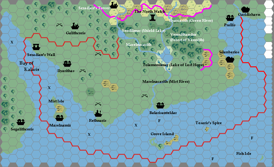
The great coastal road runs from Garidishavn and follows the coast to Prallis, Silanbarios, and around the southern part of the hills until it can run straight to Balarisanteldar, which is a junction.
The coastal road continues across the Marelnacarith to Rethnaris, and then to Ilyarithas and finally ending at Seradian's Wall. There's probably a coastal trail that continues from there, off the map, which would end up somewhere in the Third Mogrethian Empire. Not too much traffic, though, unless it's armed.
The northern road goes from Balarisanteldar to the Lake of Lost Hope, and skirts the dry edge of it to reach the North Watch.
There's also a sea route from Rethnaris to Marelnamir. Nothing connects to Segalithcoris, as the latter is a community of people expelled from the empire.
As usual, "X"s are sea battle markers, and "F" means good fishing.