Geography of Specularum
by AllanPIn looking through the Poor Wizard's Almanac AC 1012 I saw in the table of 'Average Seasonal Temperatures on page 172 that Specularum's altitude is given as 150 feet (above sea level), and it is noted "River may flood in spring".
With this potential for floods, I wonder if that may have been another reason for the installation of the Sea Gates? They may provide some form of flood defence for the harbour (We discussed the Sea Gates in this topic).
Thinking about Specularum's altitude, I also looked at the city description in the Karameikos: Kingdom of Adventure box set. This includes:
"The city sprawls over a number of small, rolling hillocks that cradle a large lake known as MirrorBay... One hill rises higher than the others and is known simply as "The Hill". Atop this dominant feature sits the king's stronghold."
"The king's castle perches on the highest hill of Mirros, atop a 15-foot-high earthen mound with steeply angled sides..."
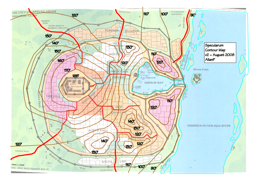
I started wondering about the lay of the land. I'm not aware of anyone discussing the elevation(s) of the city before so I put together a very "quick-and-dirty" sketch to outline what I thought might be the placement of the hillocks. This rough sketch is below
To summarise:
- I drew a "contour line" parallel to the Duke's/King's Road to indicate the probable potential flood level;
- The colours on my sketch don't directly relate to specific heights - I just used different colours to get a feel for different elevations;
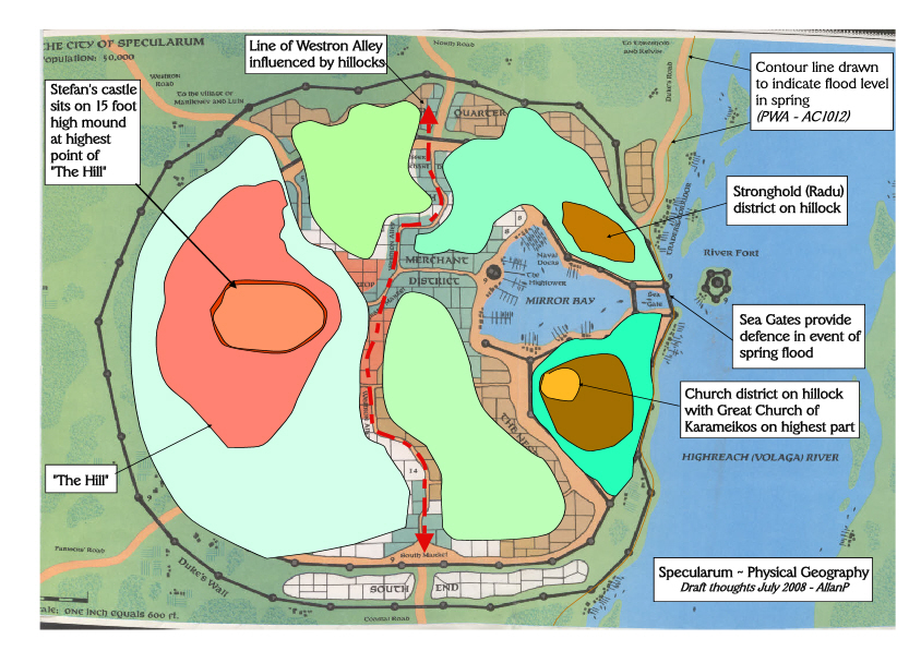
- I assumed that the two original walled encampments that are now the Stronghold (Radu) and Church districts were also probably on hillocks;
- As the Westron Alley appears to be an original major north-south route in the city area (per GAZ1), I have indicated how the surrounding hillocks may influenced the path of this;
I am no geographer/cartographer, so my sketch may be a bit inconsistent. Perhaps someone with more knowledge/skill could enhance my initial outline ideas? Maybe a 3D/perspective view of the city layout?
Thanks to the constructive comments received I've been doodling again at the contours of Specularum.
Having taken the suggestion of the "seven hills of Specularum" I realised that they needed to be inside the original city wall - otherwise an attacker would gain a certain advantage if one or more of the hills extended beyond the city fortifications. (The outer wall wasn't constructed by Stefan until he arrived in AC972). As a result, the area covered by some hills has shrunk and "The Hill" has expanded a bit, but I think I've got something fairly workable which caters for the major routes being determined by the placement of the hillocks. So I now have The Hill, a hillock in the Stronghold District, a hillock in the Church District, 3 hillocks in South End (part), Old Quarter (part) and The Nest, and 1 hillock in the North End (part).
I've taken the 150 feet altitude from PWA as being the point where the Westron Alley running north to south meets the east-west road from the docks; this seems to be a natural point for the "centre" of Specularum c. AC1000. Consequently, I calculate that the top of the mound on which the castle sits is at an altitude of 185 feet, and the dockside level is at 90 feet altitude. (The city is 8-16 miles inland upriver from the sea coast.)