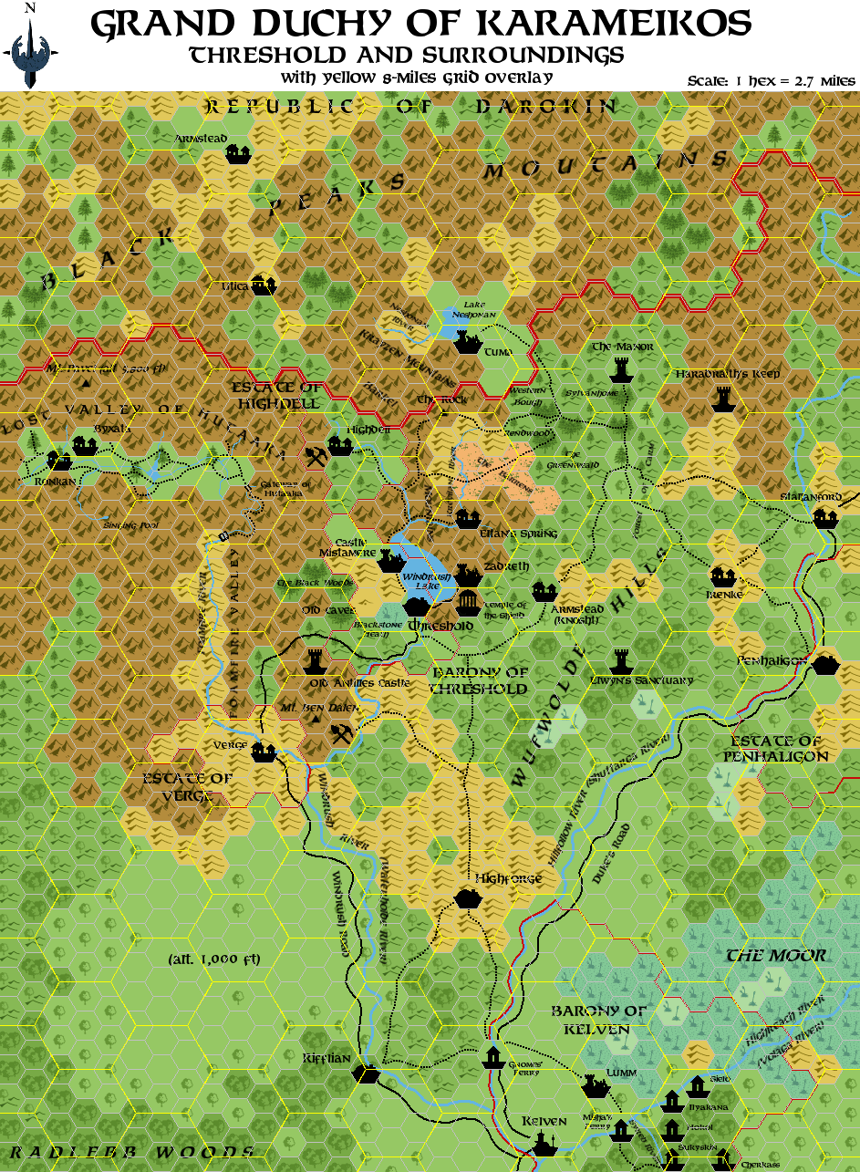
Detail of the Threshold Region
by Simone NeriDays ago, I made a map of Threshold region, based on all (to my knowledge) canon sources. Here's the map; I apologise for the odd scale, but I simply used a x3 zoom on the GAZ1 map.
I've used a style as similar as possible to Thorf's one for the map.
First the map, then some explanations:
I've incorporated in the map all the material of the B adventures, accordingly to the information given in B1-9.
The B8 area has been put in the more favourable position "north of Threshold" (B1-9, which is the most recent source about the area - the original B8's suggested placement was instead west of Threshold): rather distant from large communities and in hilly hexes (it would have been rather difficult indeed to put the area in mountainous hexes). The trails from the B8 map have been connected to other logical spots in the map above. I think it could be reasonable to connect Tuma and The Manor with other Darokin features thought trails that cross the mountain range through showed mountain passes.
Moreover, I've assumed River Krevilan from B8 to be the same river that goes north from Eltan's Springs (from K:KoA).
For the ferries farms in B10 I've used the "post house" symbol from GAZ12 - I've intended it to be any building smaller than a village (an isolated inn, farm, etc.) other than a keep, castle, etc. Obviously, the map isn't intended to show every single post house, farm of isolated inn, but only the more important (or known) ones.
The Windrush Lake's sizes have been reduced; according the measures given in K:KoA, the lake would be over three 8-miles-hexes long in N-S direction, and over one in W-E direction. Because the lake couldn't be so large (it's not even showed in the GAZ1 map), I've reduced it to fit within a single 8-miles-hex.
You'll see borders of minor fiefdoms; I've assumed that the fiefdoms whose borders were not showed in GAZ1 map to be one 8-miles-hex or smaller in size.
Last but not least, I've tried to keep the Lost Valley of Hutaaka in the position where B10 puts it. So I've not moved it westward, as GAZ1 suggests. With some minor adjustments, I've managed to keep it within Karameikos without altering B10 too much.
Some sites of the map, in alphabetical order:
Armstead (Knosht): The 'Karameikan Armstead' mentioned in the Penhaligon Trilogy novels. It has been identified with Knosht, a village mentioned in GAZ5 (description of Boris Beerthumb - here it's only said to lay in the hills east of Threshold). So Armstead should be the Thyatian name of the village, Knosht the Traladaran one.
Ben Dalen Mountain: A mountain of the Cruth/Black Peaks range near Highforge, mentioned in the Book of Wondrous Inventions; gnomes have a mine near the mountain.
Black Woods, The: In the adventure suggestions given in D&D Expert Set (which are all set in Threshold or in the vicinity), there's one concerning Bargle's "secret army"; his mercenaries, disguised as trees, dwell in "The Black Woods" west of Threshold.
Blackstone Heath: An overgrown area south of Threshold, mentioned in one of the adventure ideas featured in D&D Expert Set; there a garbage dump with a black pudding will be built in the near future.
Byxata: The Hutaakan village in the Lost Valley, from B10.
Castle Mistamere: The dungeon from the group adventure in D&D Base Set, another hideout of Bargle. It was the seat of Gygar, a mage-lord of centuries ago. The castle is identifiable with a ruined Hutaakan town north of Threshold, on the lake's shore, mentioned by GAZ1; locals don't know its Hutaakan origin. Castle Mistamere was probably built over these ancient Hutaakan ruins, and the dog-headed statues that the PCs find in the first level of the castle probably aren't kobold statues (as the Base adventure suggests), but Hutaakan statues brought up from lower levels by Gygar himself centuries ago.
Eltan's Springs: The small village in the mountains north of Threshold, from K:KoA.
Elwyn's Sanctuary: The hideout of Elwyn 'the Ardent', from B9; according to B1-9 it should lay somewhere in the wilderness areas east of Threshold.
Haradraith's Keep: The castle of the "Queen" Ilyana (the evil half-sister of Lady Penhaligon), from B12.
Highdell: Mining village north of Threshold, from D&D Expert Set (see Threshold description here). From the adventure "Ransom", in Dungeon Magazine #42, we learn that a Sir Reynard has a fief north of Threshold. I've identified Highdell with the main village of Sir Reynard's fief.
Irenke: The adventurer's paradise described in Joshuan's Almanac; we know that it's found on a cart-road that goes west of Penhaligon for about ten miles, and then again joins the Duke's Road.
Lumm: An abandoned village from X12; the mad wizard Skarda kidnapped all the inhabitants twenty years before the adventure.
Manor, The: The keep of Lydrium Arkayz, from B8.
Old Antilles Castle: The more familiar Caldwell Keep, from B9 and B1-9; as it's only abandoned and not in ruins, I've used the 'keep' symbol.
Old caves: The small dungeon where the unnamed hero from D&D Base Set first encounters Bargle and Aleena.
Rock, The: The main adventure site of B8.
Ronkan: The Traldar village in the Lost Valley, from B10.
Stallanford: The village featured in the adventures B11 and B12; I've tried to stay true to its original position (the map in the abovementioned modules is largely inconsistent with GAZ1 map).
Temple of the Shield: An ancient temple of Halav dug in the mountainside, from the adventure Hail the Heroes; it was built shortly after the Time of the Dragonlord, and it's now abandoned, its location lost to common knowledge.
Tuma: The ancient city of Tuma, featured in B8; it's not in ruin (it pops in and out the Prime Plane from the planar prison where it has been put thousands of years ago), but "ruins" seemed the best symbol for it to me.
Utica: Small village found in the adventure "Ransom" (Dungeon Magazine #42); it's about ten miles north of Karameikos' borders.
Zadreth: An abandoned and ruined village laying on the eastern shores of Lake Windrush, according to the adventure Hail the Heroes. A trail, later paved by the Grand Duke, leads there from Threshold. An almost disappeared trail leads instead from Zadreth to the Temple of the Shield.
Some other sites:
Barkel Mountains, Forest of Carm, The Barrens, The Greenweald, Krayzen Mountains, River Krevilan, Lake Neshonan, River Neshonan, The Rendwood, Sylvanhome and The Western Bough are all from B8.
Cherkass, Gnomes' Ferry, Hokol, Ilyakana, Misha's Ferry, Sielo, Sukyskin and River Syreb are all from B10.
Lastly, the ancient village named Lugsid in the adventure Hail the Heroes should be identified with an old community laying on the site of the present Threshold town.
Well, I think that's all. I hope you like it.
I'm open to any suggestions in order to improve the map, add other details and make eventual corrections.
Here is the map with the 8-miles-per-hex grid overlay.