
Location of Tuma
by RobinAs best fitting in this topic on Tuma I made this; a section of the 1 mile hexmap of Karameikos detailing the region as Canon suggested in the WEST of Karameikos instead as fanon did in the East.
Below the reasons of my decisions;
B8 page 4 ; "The player characters begin the adventure in a small village 2 miles OFF the south edge of the map. The village is directly south of the Forest of Carm".
B8 page 30 canon location suggestions; "The maps in the D&D Expert Set offer several possible settings for the adventure area. The following are all locations on the Lands and Environs of the D&D Wilderness Map of the Grand Duchy of Karameikos.
1; The area is in the Cruth Mountains, on the river northwest of Wereskalot, " This is actually Five Shires
2; "or in the Cruth Mountains on the river NORTHWEST of Threshold. The Barkel and Krayzen Mountains are extensions of the Black Peak Mountains".
3; Republic of Darokin. The area is in the mountain or hill terrain north of Lake Amsorak. The Krevilan River flows into Lake Amsorak south of the wilderness shown on Jenlar Temlin’s Map.
The suggestion of Darokin falls off, just as the suggestion placing it in the 5 shires, as it is more generally assumed this area is in Karameikos. The canon suggestion speaks clearly of the expert set map (X1)
"the river" in canon suggestion #2 is not designated, yet there are the Foamfire, Achelos and Gustos river NW of threshold, of which only the Achelos and Magos having space to conform to the B8 area in scale,
When combining the further canon, and fanon, the Gustos just above the canon source of this river fits best without altering the X1 map too much. The overall map change is nothing more than 1 mile hex shift of the dimensions of west mountainspur, now becoming the Barkel Mountains.
The village mentioned is not named, yet I named it Carm after the B8 canon " the Forest of Carm."
The three roads/trails leading south from the Forest of Carm are directed to;
Western; Gustos and further west
Central; Catavia, Popescu, Vostoi(Trail to Kelvin/Riverfork Keep)
Branching off halfway on an old no longer used Trail; Along Koskatep to Achelos
Eastern; Over Three Axes Ford to the East, with a few branch-offs to Khurest Hurgon, Krondsfield, Conyberry, Actavius, finally ending in Threshold
The 'Southern Trail" through the Barrens goes more west and meets the trail to Gustos
Two extra trails(minor) I have added according geology, and map significance yet I have not finished these yet
following the Canon and Fanon maps the area is empty enough to enable this.
In Sturm's 3.2 mile hex and Agathokles Cruth Lowlands maps, it would be north of his location of Nor Cruth Ogres, and his location 'the Camp' would then be just south where the krevilan river leaves the B8 map and merges the Gustos.
After measuring and scaling the areas of B8 aren't that large, (except the Tuma city itself, which is in fact frigging large...several miles in fact) and fit perfectly in the valley X1 made. It again fits perfectly, as if canon authors actually worked together...once...
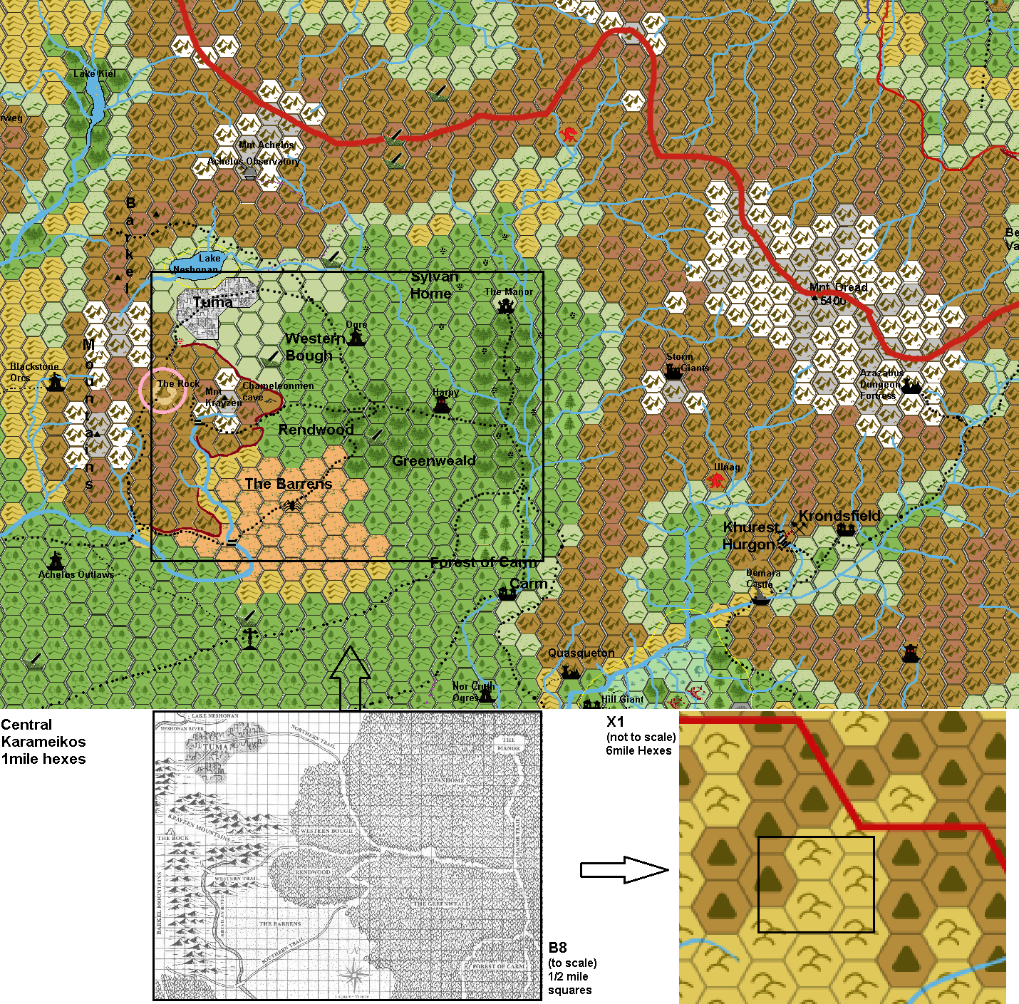
As this is a preliminary section of the 1 mile hexmap I am working on, this map is not finished, and missing altitudes and might suffer some minor changes during the development.
Hope you like it all