
Wylon
by Robin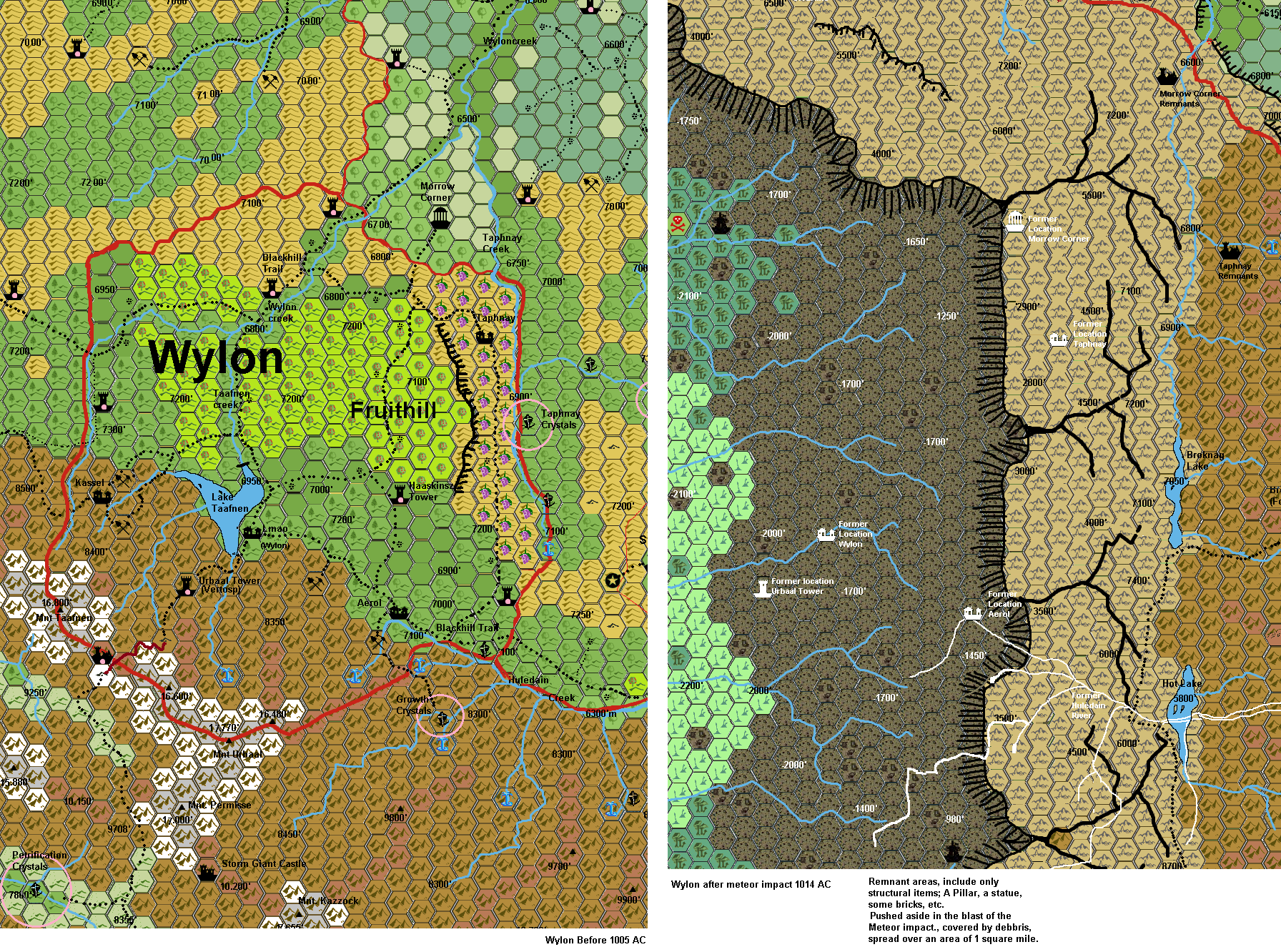
Region of area of Glantri named County of Wylon before and after being fully destroyed by the meteor impact of 1006 AC
Wylon, County of
Not to copy works from other, otherthan those altered or added to, here the source link by Agathokles
Area: 392 square miles
Population: 1890/0
Ethnic groups: Alphatian 95%, Others 5%.
Languages: Alphatian.
Ruler: Count Emeth Urbaal (born 946, Air Elementalist of the 3rd Circle) (OD&D: Mage 11th, Al CN)
House: Silverston.
Military: 1 Flying Ship with 20 sailors and a captain. Each major village has a constable, and the Blackhill troops regularly patrol this area. Emeth also keeps 8 personal bodyguards.
Food: Self-sustenance.
Villages
(population values are given for AC 1000 and AC 1014)
Lmao(also called Wylon by Glantrian politics); Altitude 6970’(378/0): located near the Blackhill borders, near a source of water, along the Blackhill Trail. Is the commercial center of the County and its largest settlementFishing, Logging, Silver mining and Fruit
Vertosp/Urbaal Tower; Altitude 8445’(175/0): few miles Southwest of Wylon. Official Magical research on clean Alchemy, herbs, and medicine. Is located close to the tower of the Count and provides services for the Count, his family and their retainers.Silver mining, Herbs, Medicine
Taphnay; Altitude 7000’ (150/0): the old Flaemish settlement.Vinyards and Fruit. Some river fishing, and crystal (still unproven theft from nearby).
Aerol; Altitude 7100’ (130/0): the most profitable mines of Silver in the mountains as of yet. Is a farming community in the southeastern hills of the County.Silver, Nuts, warm water
Kassel; Altitude 8425' (125/0) is a mining community west of the tower of the Count.
Other Hamlets (111/0).Fruits, vegetables and some ligging or wine.
Water
Lake Taafnen 6950’altitude, depth 15-85’. Human Maintained Beaverdam lake
Wylon Creek from Mount Taafnen to Red River
Taafnen creek from Mount Taafnen several brooks into Lake Taafnen to Wylon Creek.
Taphnay creek from Hot Springs in Hills north of Huledain Creek into Wylon Creek
Huledain Creek; From several brooks from Mount Urbaal, Mount Permisse, Mount Huledain, and Mount Kazzock into Huledain River,
Trails
The Blackhill Trail passes through the County from the South-east, reaching the main village from Silverston then stretching North-east towards Blackhill again. Poor and bad trails connect other villages.
Urbaal Trail, a very dangerous unguarded, natural trail south into the Silver Sierras, between mount Taafnen and mount Urbaal, eventually leading to Nathrat.
Economics: Silver is mined in the village of Aerol, and fruit is cultivated quite everywhere in the hills, as it is the main food resource of the County. Trading with the Principality of Blackhill only.
Notable sites:
Haaskinzs Tower in Wylon itself was built to serve as a secure research facility for their studies about Radiance. Whenever the reclusive Robert and Arnulf came to Wylon they used to shut themselves in the Tower, something that didn’t raise their popularity amongst the populace, as the Tower became known as Fussy Tower. Due to the hostility of the locals, they fortified and trapped it so much, that when they left to Berrym it took the new ruler, Idwal Terlagand, less time to build a new Tower than to remove all Haaskinz’s traps. But then, the "ol’ fox", came out with a mean to make money out of it: the Annual Trap Contest.
Morrow Corner, 6785’ altitude. Actually just beyond the Northern Wylon border, being part of Blackhill, this structure has some significance to the populace here. As due the Wylon Creek and Taphnay creek block passage mostly from anywhere other than from Wylon, is in effect belongs more to Wylon than Blackhill. This temple is erected with twelve walls standing like a snowcrystal, and many stones have scratsched or cut scriptures upon them. (Some bear copper, tin, or even metal shield---any of more value have been plundered long ago). Each is designated to a lost family member or hero. As thus many stones bear similar names and dates, especially of the former rulers, and adventurers who perished, but originate here. Bundles of flowers and candles can be found underneath the stones, and these are maintained by family members or friends.
Mount Urbaal This is actually a three top mountain (16.600’. 1.770’And 16.480’). It is a mountain that holds warm water from the Lower Magma Chamber (Lower Broken Lands West Chamber). As thus two geysers can be found here; one high up Mount Urbaal (9013’) and the other near Aerol, above the silver mines at 8631’. Conquered by the Former Count Alexander Wolfen in 872 AC. Southwest corner of the Wylon border.
Mount Taafnen 16.800’, Holds several silver mines.
Mount Permisse 17.000’ Actually the back end of Mount Urbaal, and beyond the border of Wylon, but important because it holds a Storm Giant castle, populated by 17 adult Storm Giants. There is often political dispute between these giants and Wylon about the mining right of Wylon, and the Giants tax on the Urbaal Trail (15 gp a head, and 25% of all commerce and items of magic and value). Remarkable these giants have an official appraiser well knowing in estimating the value of an item. As the “tax” is done halfway the path, you must always pay. Jewellery, gems, and money is taken first, any remaining debt is taken from the rest (rounded up to whole items), but these giants have a law that if one or two items are enough to pay the tax debt, that will be accepted too. Refussal is capture and slavery (often sold elsewhere).
Fruithill; A soft hill 7100’-7200’, with only its eastern side having a steep cliff of 100’. The ground is very fertile and many species of fruits are cultivated here (Apple, Pear, Cherry, Citrus, Orange, and other more rare fruits).
There are a few other wizard towers in Wylon, these are mostly social wizards, paying their taxes and taking their responsibilities.