
Darokin Locations
by Simone NeriAs I've already exposed my position on the Fenhold issue, I'll post my usual bunch of addition from canon sources:
Town (village) of Utica (from Dungeon Magazine #42, D&D Adventure "Ransom" by David Howery, July/August 1993, vol. VII no. 6, page 37)
This village is described as a "small village" or a "small town" (I'd say village), about 10 miles north of Karameikos' northern border, and north of Threshold. I think it's on a mountain pass crossing the Black Peaks from Armstead to Threshold. I fixed the position of Utica in this map at the Vaults (the second one; the yellow grid overlay represents 8-m map). As you can see, Utica's location can be chosen between three 8-m mountain hexes.
In [i]Dungeon #42, the village is described as such:
This small town survives by offering services to bandits as they move along the border. Few of the residents have any morals. The town is always starved for cash and supplies, and crime is a way of life for many.
An thus we understand perfectly why this mountain pass isn't used in favour of that crossed by the Duke's Road.
Letizia village (from Joshuan's Almanac & Book of Facts by Ann Dupuis and Elizabeth Tornabene, 1995, TSR 2517, page 230)
The village is located somewhere in Fort Lakeside's area.
Blizzard Pass (from MSOLO1 Module for Basic Set "Blizzard Pass" by David Cook, TSR 9067, 1983)
The pass is described as the "treacherous path that winds over the Cruth Mountains between the Five Shires and Darokin".
I'd say it's the one which from Mar goes to Ringrise.
Lake Eadaigh (from PC1 Tall Tales of the Wee Folk, by John Nephew, TSR 9254, 1989, Adventure Booklet, page 11)
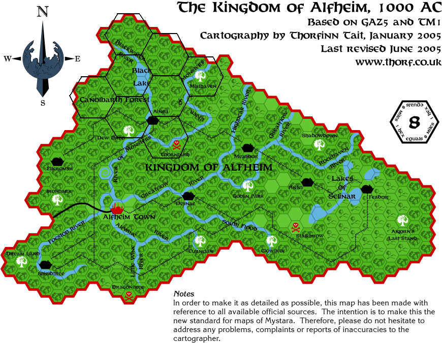
This lake could be located at the border with Alfheim, according to the adventure.
Sarsdell village
I cite myself from the topic on Glantri.
* Village of Sarsdell (from BSOLO).
Well, the location of this one is uncertain - probably it should be in Darokin at the borders of the Broken Lands, in the neighbourhood of Corunglain. But placing it in Glantri (Bramyra area or so) could be another possibility.
The indications the friend of the PC gives him on page 7 say: "Follow the Streel River east for six days, and then hike north for two. After eight days, you should be able to see that great stone lion rising from the plain", and below the module says "You cross the river by ferry and turn east to walk along the river. The great grassland of the Ethengar
Khanate stretches out ahead of you".
Now, there's no part of the Streel river along the Glantri-Ethengar border, crossing which you could find immediately within Ethengar, so probably the module skips the travel of the PC through the eastern trail passing through the Broken Land and only starts telling the story once the PC enters the steppes. This reasoning is consistent with the travel times given in the module (6 days following the streel on the trail - that is about 324 miles unencumbered and at speed x1,5 thanks to the trail - then turning north in the Kaeruts' lands and walking for additional 2 days = 6 hexes). The Lion Castle should be found in the 8-m hex above the "Gr.." of the "Sea of Grass" label in the poster map of GAZ12.
Granitgape and Misty Hills (from Lone Hero Expert Adventure "Blade of Vengeance" by Jim Bambra, TSR 9108, 1984)
These Misty Hills should be the Orclands hills around the northern tip of the Canolbarth Forest (where the dragon's lair is found).
Granitgape is instead the dwarven trade post I've indicated in the map thread dedicated to Alfheim. I cite:
Time ago, I overlaid a 24-m grid on the O2's map, and the results were these (labels in red are mine and in Italian)You can see the 24-m grid overlaid over GAZ5's 8-m map here
Now, the main problem is that the description of the Emerlas matches that of a border region, where the humanoid warbands easily penetrate and where there are also some non-elven settlements. IF one wanted to keep the size of O2's Emerlas, he would also have to explain just HOW humanoid bands could penetrate so much near Ainsun without any help arriving from Alfheim's government.
Therefore, a solution could be to reduce the size of O2's map so that the Emerlas areas could fit into the uppermost 24-m hex of Alfheim - that is on the area north of Blackwater River on the 8-m map.Anyway, interesting addition from this map are the lake of the Shining Isle (I'd connect it with the Blackwater River), the elven village of Dorneryll, the human village of Scrubton, the halfling village of Oakendale, and the dwarven stronghold of Granitgape.
Granitgape seems to be right outside Alfheim's borders, so it doesn't pose much of a problem. It could be one of the trading posts estabilished by the Rockhome dwarves' Longstrider Trading Company (see GAZ5, page 31, "The History of Trade") to trade with elves.
East Riding
I recall also such a village in the Darokinian area, but I can't find my sources... I'll make an exhaustive search.
EDIT: Thorf has found this to be another of the villges of the Barony of Fenhold (from CM9).
The Cairn (from Wrath of the Immortals boxed set by Aaron Allston, TSR 1982, 1992, on the poster map and on the "Part I: Prelude" of adventure book "Immortals' Fury")
This is simply the location where the tomb of the hero Balthac and the dragon Calor is located. The place is shown quite well on the poster map, so no more about it. As per AC 1000, there should be only the cairn of Calor and the small temple-tomb of Balthac, without accompaining barracks and quarters for clerics (likely built after the Ixion vs Rad quarrel).
And that's all for Darokin too. A couple of suggestions:
1) Emerlas Borderlands: This label should be changed IMHO, as the "Emerlas" are the northernmost tip of Alfheim, and this part of the Orclands seems to be quite far from that place. Moreover, as the Emerlas are a region of Alfheim, I don't see why the Darokinians should use an elven name for a part of their country.
I'd change it with Eastern Dwarfgate, from your previous version of the same map (this makes the Dwarfgate borderlands the Western Dwarfgate borderlands).
2) Athenos: IIRC this city has 15,000 inhabitants. Shouldn't it have the "city" symbol instead of the "town" one?
3) Orclands's settlements: how about indicating them with a different symbol (i.e. not "tower/keep", which to me seems a little unsuited for settlements of 5,000 or 10,000 orcs).