More details about Patera
by LoZompatoreThis is an attempt of mine to better detail the moon of Patera (also called Myoshima). I sketched a hexed world map with a scale at the equator of 72 miles per hex and then added some political borders and a few settlements.
(In the following I'll always address the moon as Patera while Myoshima will always refer to the Empire of Myoshima).
As a starting point I took the general map of Patera by Giovanni Paniccia and Agathokles' map of the metropolitan Empire of Myoshima. Both maps do not cover the whole surface of the moon so I filled the missing space trying to stay true to the original description of VotPA Part 7 (notably, Patera is "mostly covered by steaming jungles and earthquake-prone volcanic mountains that surround three freshwater seas").
In the following a physical map of Patera:
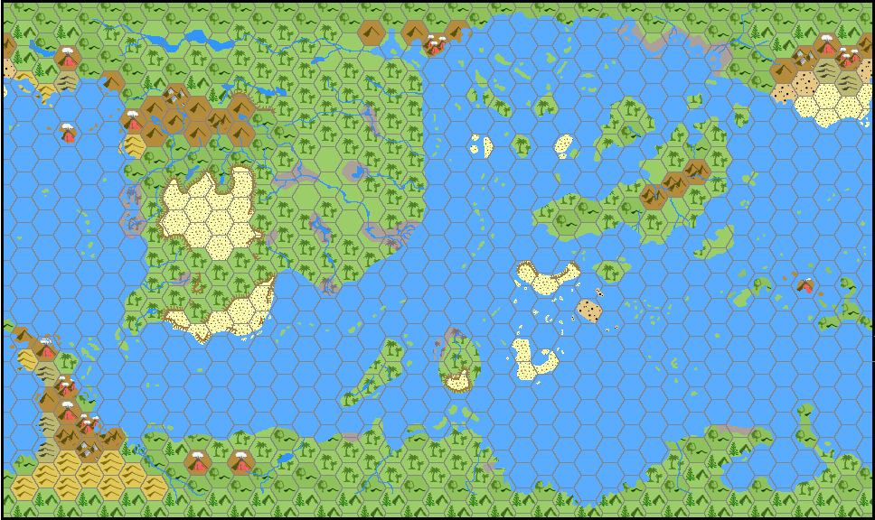
I placed the three freshwater seas in the west, in the south-east and, diagonally from south-west to north-east, in the middle of the map. The three seas are connected, although their boundaries may be set by many chains of (likely volcanic) islands. I did not give names to the oceans or to the other geographical features I added.
As you see, with respect to Giovanni Paniccia's map, I added cliffs on the northern slopes of many deserts. The idea is that, given the particular orbit of Patera around Mystara (polar and tidally locked), main wind patterns should evolve from north to south in the map, as Patera performs a full rotation around its "East-West axis" every revolution around Mystara. For this reason every time a high mountain chain or a high plateau blocks the humid winds from the north, the lands south of it should be pretty dry as clouds and rain are diverted elsewhere.
Rivers and lakes are set accordingly.
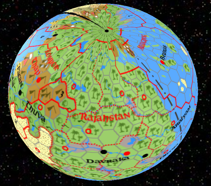
Now, let's have a look at the full political map:
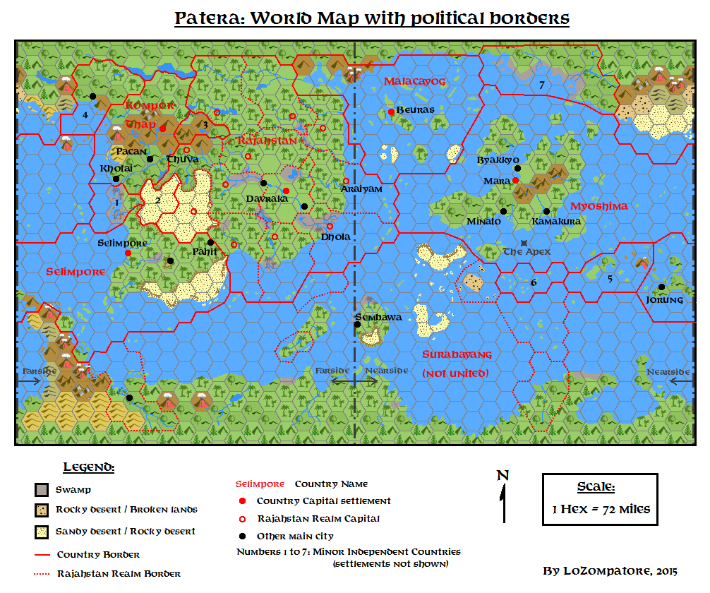
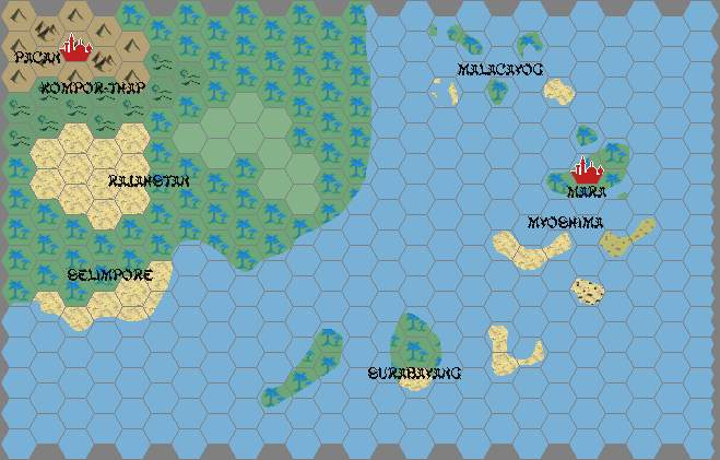
I left the major political entities (Myoshima, Rajahstan, Malacayog, Selimpore, Kompor-Thap and Surabayang) as per Giovanni Paniccia's map, updating the shape and size of Myoshima according to Agathokles' work. I added some minor countries according to the info Agathokles provided. Half a dozen minor nations are listed; I raised their number to 7, and there is room on the map for a few more.
Consider also that Surabayang territory is not united.
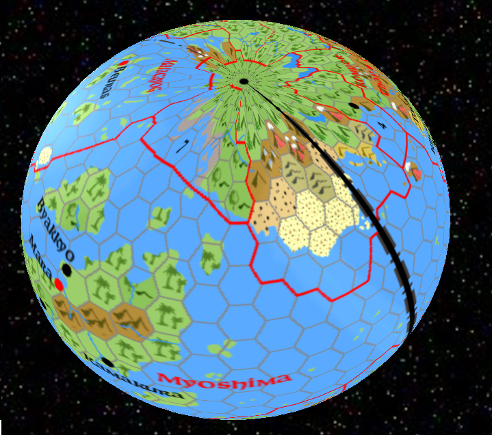
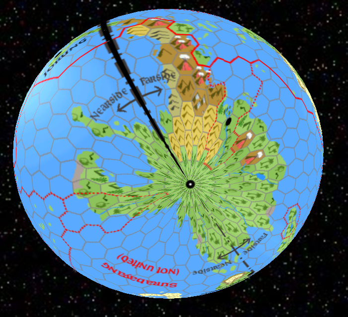
Nearside and Farside borders are shown on the map. I tried to stay true to the general descriptions provided by Andrew Theisen in the introductory article about the Patera Project. In particular, Myoshima is on Nearside, Rajahstan is on Farside, Selimpore is mostly on Farside. The other countries are placed accordingly.
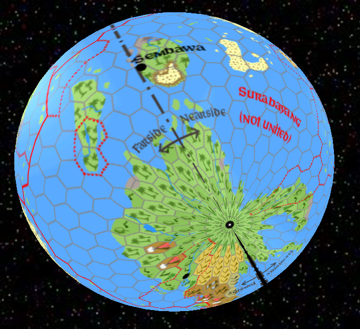
I highlighted a special spot on the map I called "The Apex" (feel free to use other names), just south of metropolitan Myoshima, which is the point of Patera right below Mystara. If a ship stands on this point and the weather is not cloudy then the crew should be able see the whole surface of Mystara moving right above their head, with a full sight of the North or South Pole every 41 hours (notice that, according to HW boxed set and VotPA, an illusion prevents the view of the polar openings - Poles appear as "ordinary" lands covered with ice if seen from space).
The Apex may have some important magic property, and nearby countries might compete for its possession.
On a side note, navigation and orientation should be fairly simple in the Nearside hemisphere, given the fact that Mystara is always visible in the sky at a given height above the horizon when the observer is placed at a given distance from the Apex. On Farside, it's a totally different matter, as the only visible celestial objects are the ever-moving Matera and the Sun. I guess sailors and captains on Farside are much more skilled than their colleagues on Nearside.
Now, let's talk a little about the countries. I buy the whole descriptions on the Patera Project and on the Gazetteer of Myoshima, without changes.
In the following a short list of additions on my side:
Myoshima: I enlarged Myoshima's borders to the east to include some minor islands and coastlines, to stay true to the description in VotPA, which says that Myoshima is the largest nation on Patera (looking at my map it seems that Surabayang is largest, but this country is actually made of many petty kingdoms and dominions). Small countries #5, #6 and #7 may be buffer or satellite states on the verge of assimilation. They could be included within the empire borders just to enlarge its size, if needed.
Rajahstan: Added the borders of the 12 kingdoms which make the confederacy of Rajahstan, with the locations of their capital cities. One of such kingdoms is entirely located in the desert on top a high plateau, maybe at war/uneasy truce with the small nation #2. I named some cities with slightly-changed names of ancient Indian locations. I added also a "capital" of the whole country (Davraka), a place where the Spiritual Council is supposed to meet.
Kompor-Thap: Added a couple of cities other than the capital settlement of Pacan, as I believe that a land with a thousand hidden temples will also need a great deal of followers. The name of the city on the coast is inspired by an ancient Nepalese location. This country is supposed to provide and receive help to/from allied Malacayog through the north pole, actually a no-man's land. At the same time Selimpore is connected to Kompor-Thap through minor nation #1. This little country and the other minor nations of the area (#2, #3, and #4) could share the same religion of some (or many) of the 1000 temples and might be considered loosely allied with Kompor-Thap.
Selimpore:Again, I added a few cities, their names are inspired from urban areas in real-world Singapore. Selimpore borders with Myoshima, Rajahstan, Surabayang and three minor nations (#1, #2 and #5). I hope this is enough to account for the mercantile bias of its people.
Malacayog: Added the capital city of Beuras, whose name is inspired by an ancient location of Malaysia. Control over the large delta of the river close to the North Pole may be contended with Rajahstan.
Surabayang: Added some internal borders of the most prominent dominions and a couple of cities. One of them, Sembawa (inspired by an ancient location of Indonesia) is placed right across the two hemispheres. I figured it as the main trading place of Surabayang, a neutral city where almost everything is available, given the right price. The dominion in the north-east entirely made of "broken land islands" may have some peculiar history and might be inhabited by intelligent beings different from rakastas, who knows.
Finally, a few pictures of the polar regions, just to give the right size to features around both extreme points:
Patera north pole view 01:
Patera north pole view 02:
Patera south pole view 01:
Patera south pole view 02: